Miranda de Ebro
Located in Province of Burgos, Castille and León Coordinates: 42°40′21″ N 2°58′13″ W

- Population
- 38,400
- 38.4K
- Elevation
- 507 m
- above sea level
- Local time
- UTC+01:00
- Europe/Madrid · UTC+01:00
- Places inside
- 25
- listed under Miranda de Ebro
- Airports
- VIT Vitoria Airport31 km
- RJL Logroño-Agoncillo Airport58 km
About Miranda de Ebro
Miranda de Ebro is a municipality. Location: Province of Burgos, Castille and León. Population: 38,400. Elevation: 507 m.
Miranda de Ebro (Spanish: [miˈɾan̪da ðe ˈeβɾo]) is a Spanish municipality belonging to the province of Burgos in the autonomous community of Castile and León. Straddling the Ebro river, near its confluence with the Bayas, the city is located on the northern watershed of the Obarenes Mountains, near the border with the Basque province of Álava and the autonomous community of La Rioja. As of 2 January 2025, the municipality has a registered population of 37,138.
Source: Wikipedia · CC BY-SA 4.0
Photos of Miranda de Ebro
-
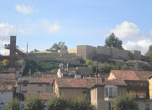
Castle of Miranda de Ebro DEb 109 · CC BY-SA 3.0

Travel notes for Miranda de Ebro
From Wikivoyage
Miranda de Ebro is in Castile and León. Although it is an industrial city, it has a rich cultural history that undoubtedly surprises the tourist who arrives. Its old town has a certain medieval touch and is being renovated. The gastronomy of Mirandesa is very rich and varied thanks to the privileged geographical situation that has united the Spanish, Rioja and Basque cuisine. It stands out above all the delicious pintxos offered by most of the bars.
Understand+
Miranda de Ebro is located in the province of Burgos, although it borders the province of Álava and the autonomous community of La Rioja. In just a radius of 80 km are the cities of Bilbao, Burgos, Logroño and Vitoria-Gasteiz (just 33 km). It is the second most important city in the province after the capital and the railway is its hallmark.
The city is very close to the Basque County but only Spanish is spoken here.
Get in+
By train:
1 Miranda de Ebro railway station. Major rail hub served by Alvia, Intercity, MD, Regional Express & Regional trains. The station was designed by the Irish engineer Charles Vignolesand opened in 1862. This station is unusual in that the booking office is not by the entrance. Head for platform 6. (updated Aug 2026)
By bus:
2 Miranda bus/coach station (Estacion de Autobuses) (in front of railway station). Inter Urban buses to Vitoria/Gasteiz, Logroño, Burgos, Madrid, San Sebastian, Badajoz, Bilbao. Basque public transport cards (BAT/BARIK/Mugi) are valid on bus 19 to/from Vitoria.Madrid & Bilbao https://www.alsa.es/ (updated Aug 2026)
By plane:
Vitoria Airport (VIT IATA, Aeropuerto de Foronda) has the advantage of being the closest airport, 35 km north-east of the city. However services are rather limited.
Bilbao Airport (BIO IATA, Aeropuerto de Bilbao) is 90 km from city.
By car:
Miranda de Ebro is well connected by road. The city can be reached via the A-1 or AP-1 if you depart from Madrid or San Sebastián or the A-68 if you depart from Barcelona or Bilbao. All these highways have direct access to the city.
Source: Wikivoyage · CC BY-SA 4.0 · abridged
Places bordering Miranda de Ebro
- Bugedo
- Santa Gadea del Cid
Population of Miranda de Ebro over time
| 2014 | 36,724 | |
|---|---|---|
| 2015 | 36,173 | |
| 2016 | 35,922 | |
| 2017 | 35,608 | |
| 2018 | 35,477 | |
| 2019 | 35,522 | |
| 2020 | 35,760 | |
| 2021 | 35,528 | |
| 2022 | 35,239 | |
| 2023 | 35,639 | |
| 2024 | 36,025 | |
| 2025 | 36,622 |
Censuses and official estimates; source: Wikidata.
Climate of Miranda de Ebro
Best months for sightseeingBest months for sightseeing: June–September.
This month · November
Outside the best season
Day 13° · Night 4° · Rain 80 mm
- Hottest month
- August (day 27°)
- Coldest month
- January (night 1°)
- Wettest month
- November (80 mm)
- Driest month
- July (37 mm)
Bars: average monthly low and high temperature. Below: precipitation. Monthly averages for 1970–2000 at about 18 km resolution, adjusted for elevation. Highlighted months are mild and relatively dry. Source: WorldClim 2.1 (CC BY 4.0).
Show values as a table
| Month | Jan | Feb | Mar | Apr | May | Jun | Jul | Aug | Sep | Oct | Nov | Dec |
|---|---|---|---|---|---|---|---|---|---|---|---|---|
| Average high (°C) | 9° | 11° | 14° | 15° | 19° | 23° | 26° | 27° | 24° | 18° | 13° | 9° |
| Average low (°C) | 1° | 2° | 3° | 5° | 8° | 11° | 13° | 13° | 11° | 8° | 4° | 3° |
| Precipitation (mm) | 71 | 60 | 55 | 79 | 72 | 52 | 37 | 41 | 42 | 66 | 80 | 72 |
Other places to visit in this season: June July August September
How to get to Miranda de Ebro
The nearest airport is Vitoria Airport (VIT), 31 km to the northeast as the crow flies. For international flights: Bilbao Airport (BIO) (70 km). The nearest large city is Vitoria-Gasteiz, 31 km to the northeast.
Airports
- Vitoria Airport (VIT) Alava 31 kmnortheast
- Logroño-Agoncillo Airport (RJL) Logroño 58 kmsoutheast
- Bilbao Airport (BIO) Bilbao 70 kmnorth
Nearby large cities
- Vitoria-Gasteiz Population: 257.4K 31 kmnortheast
- Logroño Population: 151.2K 48 kmsoutheast
- Bilbao Population: 347.3K 66 kmnorth
- Barakaldo Population: 100.4K 69 kmnorth
- Burgos Population: 176.4K 70 kmsouthwest
Straight-line distances; road distances are longer. Airport data: OurAirports.
Day trips from Miranda de Ebro
Within 100 km: 273 historic and cultural sites, 196 natural sites, 246 lakes, rivers and coasts.
0–25 km48 places
- El Lago Lake 19 kmS
- Laguna de Bayas Lake 5 kmE
- Laguna de Lacorzana Lake 6 kmE
- Pico de Toloño Mountain 18 kmE
25–60 km188 places
- Pantano de Valbornedo Lake 44 kmSE
- Pantano de Ordunte Lake 59 kmNW
- Pantano de la Grajera Lake 46 kmSE
- Pantano de González de Lacasa Lake 60 kmSE
60–100 km479 places
- Nerbioi / Nervión River 72 kmN
- Arrietara Beach 80 kmN
- Playa de San Julián Beach 88 kmN
- Laga Beach 86 kmN
Straight-line distances.
Places in Miranda de Ebro
25 placesBar: population relative to the most populous place in this list.
Cities & villages9
- Ayuelas · Village
- Bardauri · Village
- Bayas · Village
- El Ternero · Village
- Guinicio · Village
- Ircio · Village
- Montañana · Village
- Suzana · Village
- Valverde de Miranda · Village
Lakes, rivers & coasts3
- Baia · River
- Laguna de Bayas · Lake
- Río Oroncillo · River
Heritage & sights10
- Antonio Machado · Attraction
- Castle of Miranda de Ebro · Historic site
- Estadio de Anduva · Landmark
- Iglesia del Espíritu Santo · Attraction
- Iglesia de San Juan · Attraction
- Iglesia de Santa María · Attraction
- Jardin Botanico de Miranda de Ebro · Attraction
- Miranda de Ebro Botanical Garden · Attraction
- Teatro Apolo · Attraction
- Teatro de la Casa Municipal de Cultura de Miranda de Ebro · Attraction
Nearby attractions & nature
Everything nearby-
Montes Obarenes Mountain, Cellorigo5 km SW
-
Zadorra River, Zambrana5.8 km E
-
Laguna de Lacorzana Lake, Armiñón Municipality5.9 km E
-
Río Ayuda River, Spain6.9 km E
-
Santamancos Mountain, Lantarón9.5 km NW
-
Castillo de Sajazarra Historic site, Sajazarra9.2 km S
-
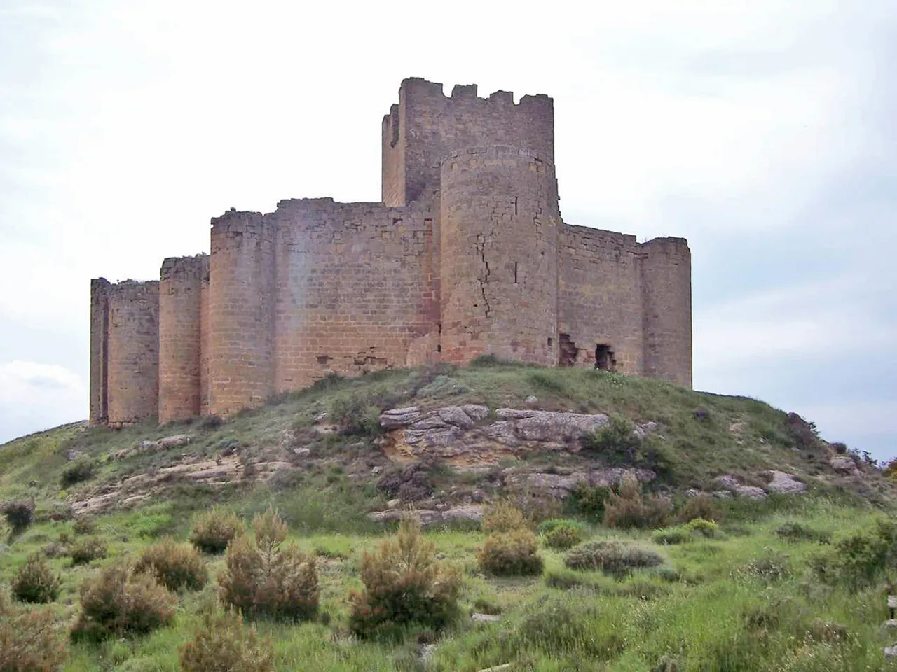 Castillo de Davalillo Historic site, San Asensio25 km SE
-
Castillo De Bilibio Historic site, Haro11 km SE
Other cities and towns in Province of Burgos
-
 Valle de Tobalina Municipality, Province of Burgos29 km NW
-
 Altable Municipality, Province of Burgos12 km SW
-
 Pancorbo Municipality, Province of Burgos13 km W
-
 Villanueva de Teba Municipality, Province of Burgos16 km W
-
 Miraveche Municipality, Province of Burgos18 km W
-
 Cubo de Bureba Municipality, Province of Burgos20 km W
Sources & licences
Data last updated: · 2 independent sources