- Population
- 8,000
- 8K
- Elevation
- 2 m
- above sea level
- Local time
- UTC+01:00
- Europe/Madrid · UTC+01:00
- Airports
- GRO Girona-Costa Brava Airport48 km
- PGF Perpignan-Rivesaltes (Llabanère) Airport59 km
About Empuriabrava
Empuriabrava is a town. Location: Castelló d'Empúries, Girona. Population: 8,000. Elevation: 2 m.
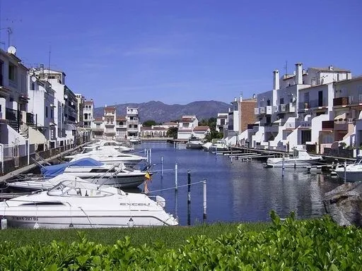
Empuriabrava (Spanish: Ampuriabrava) is a community in the municipality of Castelló d'Empúries, in the Alt Empordà (Costa Brava, province of Girona, Catalonia, Spain). It is located in the Gulf of Roses, surrounded by the Natural Park of the Aiguamolls de l'Empordà, and is the largest residential marina in Europe, with some 24 km of navigable waterways. Originally built on a swamp, Empuriabrava was transformed into a tourist community, initially planned in 1964 and completed in 1975.
Source: Wikipedia · CC BY-SA 4.0
At a glance
- Built
- 1975
Source: Wikidata
Photos of Empuriabrava
-

Japleenpasricha · CC BY-SA 4.0 -

JOZUAL · CC BY-SA 4.0 -

JOZUAL · CC BY-SA 4.0 -

Japleenpasricha · CC BY-SA 4.0 -

Jozual · CC BY-SA 3.0


Travel notes for Empuriabrava
From Wikivoyage
Empuriabrava (Ampuriabrava in Spanish) is a tourist area of 1 Castelló d'Empúries town approximately 120 km northeast of Barcelona on the coast of Girona in Catalonia. The town is home to one of the world's largest man-made marinas with channels cutting through the whole northern part of the urban area.
Understand+
The town consists mostly of tourist accommodations creating great seasonal changes with an estimated population of 80,000 in the summer dropping to just a few thousands in winter.
Tourist information
Get in+
By car:
From Europe: Crossing the French border by motorway AP-7 or state road N-II. The exit of the motorway is the nº 3. State road C-260, direction Figueres. The road to Empuriabrava is the C-260, taking the Figueres-Roses exit, direction Roses.
From Barcelona or Girona: By motorway AP-7 or state road N-II. The exit of the motorway is the nº 4. State road C-260, direction France. The road to Empuriabrava is the C-260, taking the Figueres-Roses exit, direction Roses.
From the Pyrenees: State road N-260, direction Figueres. After Navata, turn right, the road C-26 direction Castelló d'Empúries. Then, the state road N-II direction France. The road to Empuriabrava is the C-260, taking the Figueres-Roses exit, direction Roses.
By bus:
Buses from Barcelona, and Girona.
By train:
The nearest train station (RENFE) is in Figueres, 15 km from Empuriabrava. From there, bus towards Castelló d'Empúries and Empuriabrava.
AVE and TGV trains arrive at the Figueres-Vilafant railway station. From there, there are buses back to the bus station in Figueres, and from the Bus Station, there are buses to Castelló d'Empúries and Empuriabrava.
By plane:
Girona Airport: The nearest airport is Girona-Costa Brava, an important base for Ryanair. During the summer season, a bus to the town is available.
The major international airport at Barcelona-El Prat is 160 km to the south, around two hours by car. There is a bus from Barcelona Airport to Figueres, and then take a second bus to Empuriabrava.
By boat:
Empuriabrava is a huge marina with many private docking places. There is a public port also.
1 Marina D’Empuriabrava, Sector Club Nàutic Edf. Capitania s/n, ☏ +34 972 451 239, info@empuriaport.com. (updated Sep 2023)
Source: Wikivoyage · CC BY-SA 4.0 · abridged
Population of Empuriabrava over time
| 1991 | 1,308 | |
|---|---|---|
| 2000 | 3,227 | |
| 2010 | 8,122 | |
| 2023 | 7,431 | |
| 2024 | 7,766 | |
| 2025 | 7,925 |
Censuses and official estimates; source: Wikidata.
Climate of Empuriabrava
Best months for sightseeingBest months for sightseeing: May–July, September–October.
This month · November
Outside the best season
Day 16° · Night 7° · Rain 47 mm
- Hottest month
- July (day 29°)
- Coldest month
- January (night 4°)
- Wettest month
- October (80 mm)
- Driest month
- July (18 mm)
Bars: average monthly low and high temperature. Below: precipitation. Monthly averages for 1970–2000 at about 18 km resolution, adjusted for elevation. Highlighted months are mild and relatively dry. Source: WorldClim 2.1 (CC BY 4.0).
Show values as a table
| Month | Jan | Feb | Mar | Apr | May | Jun | Jul | Aug | Sep | Oct | Nov | Dec |
|---|---|---|---|---|---|---|---|---|---|---|---|---|
| Average high (°C) | 13° | 14° | 16° | 18° | 22° | 25° | 29° | 29° | 26° | 21° | 16° | 14° |
| Average low (°C) | 4° | 5° | 6° | 8° | 12° | 16° | 18° | 18° | 16° | 12° | 7° | 5° |
| Precipitation (mm) | 36 | 37 | 46 | 48 | 43 | 37 | 18 | 40 | 66 | 80 | 47 | 48 |
Other places to visit in this season: May June July September October
How to get to Empuriabrava
The nearest airport is Girona-Costa Brava Airport (GRO), 48 km to the southwest as the crow flies. The nearest large city is Girona, 38 km to the southwest.
Airports
- Girona-Costa Brava Airport (GRO) Girona 48 kmsouthwest
- Perpignan-Rivesaltes (Llabanère) Airport (PGF) Perpignan/Rivesaltes 59 kmnorth
- Béziers Vias airport (BZR) Béziers 121 kmnorth
Nearby large cities
- Girona Population: 100.3K 38 kmsouthwest
- Perpignan Population: 110.7K 53 kmnorth
- Mataró Population: 127K 96 kmsouthwest
- Badalona Population: 217.7K 114 kmsouthwest
- Sabadell Population: 211.7K 115 kmsouthwest
Straight-line distances; road distances are longer. Airport data: OurAirports.
Day trips from Empuriabrava
Within 100 km: 267 historic and cultural sites, 1,002 natural sites, 275 lakes, rivers and coasts.
0–25 km235 places
- Platja de Perafita Beach 24 kmN
- Puig Joan Mountain 23 kmN
- Platja de Port-alguer Beach 14 kmE
- Platja de l'Estartit Beach 23 kmS
25–60 km533 places
- Platja de Port Pelegrí Beach 40 kmS
- Platgeta d'en Cosme Beach 40 kmS
- Platja d'en Calau Beach 40 kmS
- Platja d'Aiguablava Beach 36 kmS
60–100 km776 places
- Platja de Lloret Beach 65 kmS
- Platja de Canyelles Beach 63 kmS
- Playa de Sant Simó Beach 96 kmSW
- sa Platja Beach 61 kmS
Straight-line distances.
Nearby attractions & nature
Everything nearby-
Platja d'Empuriabrava Beach, Castelló d'Empúries0.9 km SE
-
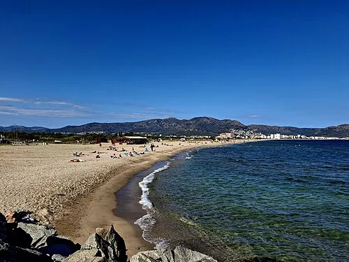 Platja de la Rovina Beach, Castelló d'Empúries2 km NE
-
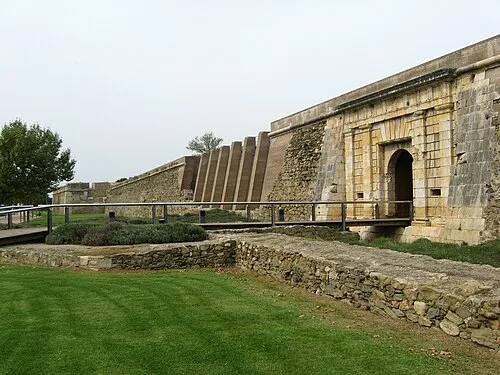 Ciutadella de Roses Historic site, Roses4.7 km NE
-
Butterfly Park Empuriabrava Attraction, Castelló d'Empúries3.2 km NW
-
Platja del Salatar Beach, Roses3.4 km NE
-
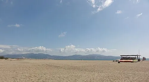 Platja de Can Comes Beach, Castelló d'Empúries4.1 km S
-
Parc Natural dels Aiguamolls de l'Empordà Natural site, Sant Pere Pescador3.4 km SW
-
Ecomuseu-Farinera de Castelló d'Empúries Museum, Castelló d'Empúries3.8 km W
Sources & licences
Data last updated: · 2 independent sources