- Elevation
- 975 m
- above sea level
- Local time
- UTC+01:00
- Europe/Madrid · UTC+01:00
- Airports
- REU Reus Airport19 km
- ILD Lleida-Alguaire Airport64 km
About la Febró
la Febró is a village. Location: la Febró Municipality, Tarragona. Elevation: 975 m. The best months to visit are June–September. The nearest airport is Reus Airport (19 km). Nearby sights include Punta del Sec and Serra d'en Garcià.
Photos of la Febró
-
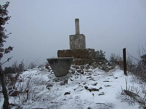
Tossal de la Baltasana Montfranc · CC BY-SA 3.0

Climate of la Febró
Best months for sightseeingBest months for sightseeing: June–September.
This month · November
A cold month
Day 11° · Night 2° · Rain 61 mm
Better nearby cities in November
- Alicante · 349 km south20°
- Elche · 364 km southwest20°
- Orihuela · 391 km southwest20°
- Hottest month
- July (day 25°)
- Coldest month
- January (night -1°)
- Wettest month
- October (73 mm)
- Driest month
- July (20 mm)
Bars: average monthly low and high temperature. Below: precipitation. Monthly averages for 1970–2000 at about 18 km resolution, adjusted for elevation. Highlighted months are mild and relatively dry. Source: WorldClim 2.1 (CC BY 4.0).
Show values as a table
| Month | Jan | Feb | Mar | Apr | May | Jun | Jul | Aug | Sep | Oct | Nov | Dec |
|---|---|---|---|---|---|---|---|---|---|---|---|---|
| Average high (°C) | 7° | 9° | 11° | 13° | 17° | 21° | 25° | 25° | 21° | 16° | 11° | 8° |
| Average low (°C) | -1° | -1° | 1° | 3° | 6° | 10° | 13° | 13° | 11° | 7° | 2° | 0° |
| Precipitation (mm) | 41 | 33 | 46 | 52 | 68 | 50 | 20 | 42 | 68 | 73 | 61 | 52 |
Other places to visit in this season: June July August September
How to get to la Febró
The nearest airport is Reus Airport (REU), 19 km to the southeast as the crow flies. The nearest large city is Reus, 15 km to the southeast.
Airports
- Reus Airport (REU) Reus 19 kmsoutheast
- Lleida-Alguaire Airport (ILD) Lleida 64 kmnorthwest
- Josep Tarradellas Barcelona-El Prat Airport (BCN) Barcelona 90 kmeast
Nearby large cities
- Reus Population: 103.5K 15 kmsoutheast
- Tarragona Population: 141.5K 26 kmsoutheast
- Lleida Population: 140.8K 50 kmnorthwest
- Terrassa Population: 218.5K 91 kmeast
- L'Hospitalet de Llobregat Population: 257K 93 kmeast
Straight-line distances; road distances are longer. Airport data: OurAirports.
Day trips from la Febró
Within 100 km: 461 historic and cultural sites, 402 natural sites, 200 lakes, rivers and coasts.
0–25 km104 places
- Puig Rafols Mountain 20 kmN
- Dent de Ponent Mountain 5 kmSE
- Sierra de la Llena Mountain 21 kmW
- Puig d'en Cama Mountain 9 kmSE
25–60 km284 places
- Playa del Rincón Beach 27 kmSE
- Playa de Rifá Beach 25 kmS
- Playa Barà Beach 41 kmE
- Platja Llarga Beach 30 kmSE
60–100 km675 places
- Playa del Río Beach 99 kmSW
- Platja del Marjal Beach 89 kmSW
- L'Estanyet Beach 90 kmSW
- Platja de Garbí Beach 80 kmSW
Straight-line distances.
Nearby attractions & nature
Everything nearby-
Punta del Sec Mountain, Vilaplana2.3 km S
-
Serra d'en Garcià Mountain, Vilaplana3.2 km E
-
Tossal de la Baltasana Mountain, Vimbodí i Poblet6.6 km N
-
Puig Pelat Mountain, Vilaplana4.6 km E
-
Dent de Ponent Mountain, Vilaplana4.6 km SE
-
Pena-Roja Mountain, Capafonts Municipality4.7 km NE
Sources & licences
Data last updated: