Wädenswil
Located in Horgen District, Canton of Zurich Coordinates: 47°13′30″ N 8°39′07″ E
- Population
- 24,624
- 24.6K
- Elevation
- 597 m
- above sea level
- Local time
- UTC+01:00
- Europe/Zurich · UTC+01:00
- Places inside
- 136
- listed under Wädenswil
- Airports
- ZRH Zürich Airport27 km
- ACH Sankt Gallen Altenrhein Airport74 km
About Wädenswil
Wädenswil is a municipality. Location: Horgen District, Canton of Zurich. Population: 24,624. Elevation: 597 m. The best months to visit are June–September. The nearest airport is Zürich Airport (27 km). Nearby sights include Au Peninsula and Ruine "Alt Wädenswil".
Photos of Wädenswil
-
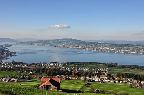
Pfannenstiel Roland zh · CC BY-SA 3.0

Climate of Wädenswil
Best months for sightseeingBest months for sightseeing: June–September.
This month · November
A cold month
Day 7° · Night 1° · Rain 99 mm
- Hottest month
- July (day 23°)
- Coldest month
- January (night -3°)
- Wettest month
- June (146 mm)
- Driest month
- January (72 mm)
Bars: average monthly low and high temperature. Below: precipitation. Monthly averages for 1970–2000 at about 18 km resolution, adjusted for elevation. Highlighted months are mild and relatively dry. Source: WorldClim 2.1 (CC BY 4.0).
Show values as a table
| Month | Jan | Feb | Mar | Apr | May | Jun | Jul | Aug | Sep | Oct | Nov | Dec |
|---|---|---|---|---|---|---|---|---|---|---|---|---|
| Average high (°C) | 3° | 5° | 9° | 12° | 18° | 20° | 23° | 22° | 18° | 13° | 7° | 4° |
| Average low (°C) | -3° | -2° | 1° | 3° | 8° | 11° | 13° | 13° | 9° | 6° | 1° | -2° |
| Precipitation (mm) | 72 | 85 | 78 | 94 | 113 | 146 | 143 | 138 | 101 | 92 | 99 | 89 |
Other places to visit in this season: June July August September
How to get to Wädenswil
The nearest airport is Zürich Airport (ZRH), 27 km to the north as the crow flies. The nearest large city is Zurich, 18 km to the northwest.
Airports
- Zürich Airport (ZRH) Zurich 27 kmnorth
- Sankt Gallen Altenrhein Airport (ACH) St. Gallen 74 kmnortheast
- Bodensee Airport Friedrichshafen (FDH) Friedrichshafen 82 kmnortheast
Nearby large cities
- Zurich Population: 415.4K 18 kmnorthwest
- Winterthur Population: 111.8K 32 kmnorth
- Basel Population: 177.6K 89 kmnorthwest
- Bern Population: 121.6K 97 kmwest
- Freiburg im Breisgau Population: 237.5K 105 kmnorthwest
Straight-line distances; road distances are longer. Airport data: OurAirports.
Day trips from Wädenswil
Within 100 km: 525 historic and cultural sites, 5,539 natural sites, 1,060 lakes, rivers and coasts.
0–25 km306 places
- Ufenau Island 10 kmE
- Insel Lützelau Island 11 kmE
- Schönenwerd Island 5 kmSE
- Insel Schwanau Island 22 kmS
25–60 km2,279 places
- Fahr Abbey Attraction 26 kmNW
- Strandbad Steckborn Beach 54 kmNE
- Arbeiterstrandbad Tennwil Beach 34 kmW
- Sankt-Niklausen-Insle Island 31 kmSW
60–100 km4,539 places
- Kleiner Bremgartenwald Mountain 97 kmW
- Mainau Island 67 kmNE
- Dominikanerinsel Konstanz Island 63 kmNE
- Strandbad Neuhaus Beach 88 kmSW
Straight-line distances.
Places in Wädenswil
136 places- 1 Wädenswil 13.3K
- 2 Au 4.8K
- 3 Wädenswil / Büelen 2.7K
- 4 Au / Mittel-Dorf 2.6K
- 5 Wädenswil / Dorf (Wädenswil) 2.6K
- 6 Wädenswil / Untermosen-Fuhr 2K
- 7 Wädenswil / Leihof-Mühlebach 1.8K
- 8 Wädenswil / Boller-Giessen 1.5K
- 9 Wädenswil / Hangenmoos 1.4K
- 10 Wädenswil / Eichweid 1.3K
- 11 Au / Unter-Dorf 1.2K
- 12 Au / Ober-Ort/Gwad 979
- 13 Schönenberg 468
- 14 Hütten 451
- 15 Fernegg 160
- 16 Palmisacker 96
- 17 Herrlisberg 77
- 18 Matte 66
- 19 Zweierhof 65
- 20 Au / Hinter-Rüti 54
- 21 Sonnenblick 52
- 22 Humbel 47
- 23 Tanne 47
- 24 Stollen 45
- 25 Au 43
- 26 Haslaub 40
- 27 Mühlestalden 38
- 28 Felsen 35
- 29 Segel 35
- 30 Säge 32
- 31 Unter-Gisenrüti 32
- 32 Feld 30
- 33 Hintere Stollen 30
- 34 Sennhus 30
- 35 Bachgaden 29
- 36 Neubad 29
- 37 Langrüti 28
- 38 Vorder-Langmoos 28
- 39 Egg 27
- 40 Eichmüli 27
- 41 Mittlere Langwies 27
- 42 Ober-Schluchtal 26
- 43 Waggital 26
- 44 Müsli 25
- 45 Beichlen 24
- 46 Strasshus 24
- 47 Külpen 22
- 48 Zollingerhüser 21
- 49 Allenwinden 20
- 50 Ober-Himmeri 20
- 51 Rechberg 20
- 52 Bubenwies 19
- 53 Hinter-Langmoos 18
- 54 Ober-Gisenrüti 18
- 55 Unter Oerischwand 18
- 56 Gisihegi 17
- 57 Gschwend 17
- 58 Niedersaum 17
- 59 Täglischür 17
- 60 Unter-Feld 17
Bar: population relative to the most populous place in this list.
Nearby attractions & nature
Everything nearby-
Au Peninsula Natural site, Canton of Zurich2.8 km N
-
Ruine "Alt Wädenswil" Historic site, Richterswil2.8 km SE
-
Aabach Wasserfall Natural site, Canton of Zurich2.9 km NW
-
Ausee Lake, Canton of Zurich2.8 km N
-
Lake Zurich Lake, Switzerland3.9 km E
-
Sternenweiher Lake, Richterswil4.3 km SE
-
Schönenwerd Island, Horgen District5.5 km SE
-
Sternenweiher Lake, Richterswil4.4 km SE
Sources & licences
Data last updated: