- Elevation
- 3,042 m
- above sea level
- Local time
- UTC+03:00
- Europe/Istanbul · UTC+03:00
- Airports
- ERZ Erzurum International Airport22 km
- BGG Bingöl Airport113 km
About Tavşan Tepesi
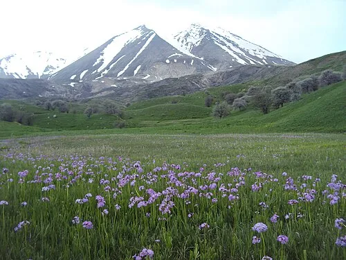
Tavşan Tepesi is a mountain. Location: Çat İlçesi, Erzurum Province. Elevation: 3,042 m. The best months to visit are July–August. The nearest airport is Erzurum International Airport (22 km). Nearby sights include Ziyaret Tepesi and Karakaya Tepesi.
Climate of Tavşan Tepesi
Best months for sightseeingBest months for sightseeing: July–August.
This month · November
A cold month
Day 0° · Night -9° · Rain 69 mm
Better nearby cities in November
- Cizre · 284 km south20°
- Kızıltepe · 291 km south19°
- Silopi · 301 km south20°
- Hottest month
- August (day 21°)
- Coldest month
- January (night -17°)
- Wettest month
- May (97 mm)
- Driest month
- August (22 mm)
Bars: average monthly low and high temperature. Below: precipitation. Monthly averages for 1970–2000 at about 18 km resolution, adjusted for elevation. Highlighted months are mild and relatively dry. Source: WorldClim 2.1 (CC BY 4.0).
Show values as a table
| Month | Jan | Feb | Mar | Apr | May | Jun | Jul | Aug | Sep | Oct | Nov | Dec |
|---|---|---|---|---|---|---|---|---|---|---|---|---|
| Average high (°C) | -8° | -8° | -5° | 2° | 9° | 14° | 20° | 21° | 17° | 8° | 0° | -7° |
| Average low (°C) | -17° | -16° | -12° | -6° | -2° | 2° | 5° | 5° | 1° | -4° | -9° | -14° |
| Precipitation (mm) | 51 | 55 | 63 | 92 | 97 | 55 | 27 | 22 | 27 | 70 | 69 | 60 |
How to get to Tavşan Tepesi
The nearest airport is Erzurum International Airport (ERZ), 22 km to the north as the crow flies. The nearest large city is Erzurum, 18 km to the northeast.
Airports
- Erzurum International Airport (ERZ) Erzurum 22 kmnorth
- Bingöl Airport (BGG) Bingöl 113 kmsouthwest
- Muş Airport (MSR) Muş 120 kmsouth
Nearby large cities
- Erzurum Population: 767.8K 18 kmnortheast
- Bingoel Population: 128.9K 114 kmsouthwest
- Erzincan Population: 150.7K 146 kmwest
- Rize Population: 119.8K 151 kmnorth
- Ağrı Population: 124.5K 159 kmeast
Straight-line distances; road distances are longer. Airport data: OurAirports.
Day trips from Tavşan Tepesi
Within 100 km: 10 historic and cultural sites, 911 natural sites, 464 lakes, rivers and coasts.
0–25 km126 places
- Yıldırım Dağı Mountain 15 kmE
- Paklı Tepe Mountain 25 kmW
- Konakgörmez Dağı Mountain 15 kmW
- Konakgörmez Dağı Mountain 21 kmSE
25–60 km834 places
- Bahri Gölü Lake 51 kmS
- Taşlı Göl Lake 36 kmW
- Büyük Göl Lake 36 kmW
- Medek Gölleri Lake 39 kmW
60–100 km425 places
- Seki Gölü Lake 63 kmS
- Lake Akdoğan Lake 84 kmSE
- Nilüfer Gölü Lake 89 kmSE
- Derik Gölü Lake 92 kmSE
Straight-line distances.
Nearest towns and villages
-
Başköy Village, Çat İlçesi5.5 km S
-
Konaklı Village, Palandöken4.5 km N
-
Tekederesi Village, Palandöken5.3 km N
-
Çukurçayır Village, Çat İlçesi9.4 km S
-
Yağmurcuk Village, Palandöken6.7 km W
-
Taşlıgüney Village, Palandöken7.9 km NW
Nearby attractions & nature
Everything nearby-
Ziyaret Tepesi Mountain, Çat İlçesi3.1 km SW
-
Karakaya Tepesi Mountain, Çat İlçesi3 km E
-
Palandöken Dağları Mountain, Erzurum Province5.6 km NE
-
Şarp Tepesi Mountain, Çat İlçesi6.6 km S
-
Karakaya Tepesi Mountain, Palandöken7.8 km W
-
Karagöl Dağları Mountain, Erzurum Province8.6 km SE
-
Eğerli Dağı Mountain, Palandöken8.6 km NE
-
 Karasu - Aras Dağları Mountain, Erzurum Province12 km NE
Sources & licences
Data last updated: