- Elevation
- 140 m
- above sea level
- Local time
- UTC+00:00
- Europe/London · UTC+00:00
- Places inside
- 8
- listed under St. John Beckermet
- Airports
- IOM Isle of Man Airport85 km
- NCL Newcastle International Airport133 km
About St. John Beckermet
St. John Beckermet is a village. Location: Cumberland, Cumbria. Elevation: 140 m. The best months to visit are June–August. The nearest airport is Isle of Man Airport (85 km). Nearby sights include Egremont Castle and Haile Hall.
Photos of St. John Beckermet
-
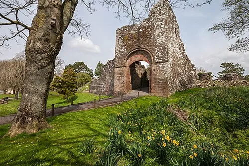
Egremont Castle Paul Lakin · CC BY 3.0

Climate of St. John Beckermet
Best months for sightseeingBest months for sightseeing: June–August.
This month · November
A wet month
Day 8° · Night 3° · Rain 112 mm
- Hottest month
- July (day 18°)
- Coldest month
- January (night 0°)
- Wettest month
- October (114 mm)
- Driest month
- May (59 mm)
Bars: average monthly low and high temperature. Below: precipitation. Monthly averages for 1970–2000 at about 18 km resolution, adjusted for elevation. Highlighted months are mild and relatively dry. Source: WorldClim 2.1 (CC BY 4.0).
Show values as a table
| Month | Jan | Feb | Mar | Apr | May | Jun | Jul | Aug | Sep | Oct | Nov | Dec |
|---|---|---|---|---|---|---|---|---|---|---|---|---|
| Average high (°C) | 6° | 6° | 8° | 11° | 14° | 16° | 18° | 18° | 15° | 12° | 8° | 6° |
| Average low (°C) | 0° | 0° | 2° | 3° | 6° | 9° | 11° | 10° | 8° | 6° | 3° | 1° |
| Precipitation (mm) | 112 | 80 | 81 | 61 | 59 | 61 | 66 | 79 | 89 | 114 | 112 | 114 |
How to get to St. John Beckermet
The nearest airport is Isle of Man Airport (IOM), 85 km to the southwest as the crow flies. The nearest large city is Blackpool, 79 km to the south.
Airports
- Isle of Man Airport (IOM) Castletown, Rushen 85 kmsouthwest
- Newcastle International Airport (NCL) Newcastle upon Tyne, Tyne and Wear 133 kmnortheast
- Liverpool John Lennon Airport (LPL) Liverpool 133 kmsouth
Nearby large cities
- Blackpool Population: 145K 79 kmsouth
- Preston Population: 313.3K 94 kmsoutheast
- Blackburn Population: 146.5K 104 kmsoutheast
- Burnley Population: 149.4K 112 kmsoutheast
- Wigan Population: 175.4K 118 kmsoutheast
Straight-line distances; road distances are longer. Airport data: OurAirports.
Day trips from St. John Beckermet
Within 100 km: 507 historic and cultural sites, 2,140 natural sites, 443 lakes, rivers and coasts.
0–25 km397 places
- St. Bees Beach Seafront Beach 7 kmW
- Scale Island Island 16 kmNE
- Watness Coy Island 18 kmSE
- Otter Island Island 25 kmNE
25–60 km1,072 places
- High Moor Mountain 37 kmSE
- Roanhead Beach Beach 38 kmSE
- Powillimount Beach Beach 47 kmN
- Tuft Rock Island 39 kmE
60–100 km1,621 places
- British Isles Island 61 kmSW
- St Anne's Beach Beach 86 kmS
- Murrays Isles Island 61 kmNW
- Ardwall Isle Island 61 kmNW
Straight-line distances.
Places in St. John Beckermet
8 placesBar: population relative to the most populous place in this list.
Cities & villages4
- Carleton · Village
- Saint Bridget Beckermet · Village
- Saint John Beckermet · Village
- Thornhill · Village
Mountains & nature1
- Winscales Hill · Mountain
Heritage & sights2
- Caernarvon Castle · Historic site
- Wodowbank Cop · Historic site
Nearby attractions & nature
Everything nearby-
Egremont Castle Historic site, Egremont2 km NW
-
Haile Hall Landmark, Haile1.1 km E
-
Head of Haile Mountain, Haile2 km E
-
St Mary Roman Catholic Church, Egremont Attraction, Egremont2.2 km NW
-
Abbey Flatts Historic site, St. Bridget Beckermet3.2 km SE
-
Braystones Brough Hill Historic site, Lowside Quarter3.8 km SW
Other cities and towns in Cumberland
-
Cleator Moor Village, Cumberland5 km N
-
Ponsonby Village, Cumberland5.5 km SE
-
St. Bees Village, Cumberland6.5 km NW
-
Saint Bees Village, St. Bees6 km NW
-
Moor Row Village, Egremont5.5 km N
-
 Calder Bridge Village, Ponsonby3.7 km SE
Sources & licences
Data last updated: