- Population
- 19,158
- 19.2K
- Elevation
- 53 m
- above sea level
- Local time
- UTC+00:00
- Europe/London · UTC+00:00
- Airports
- LHR London Heathrow Airport15 km
- LTN London Luton Airport31 km
About Pinner
Pinner is a town. Location: Harrow, Greater London. Population: 19,158. Elevation: 53 m.
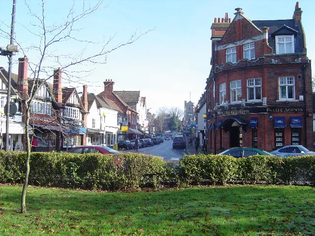
Pinner is a suburb in the London Borough of Harrow, northwest London, England, 12 miles (19 km) northwest of Charing Cross, close to the border with Hillingdon, historically in the county of Middlesex. The population was 38,698 in 2021. Pinner originated as a mediaeval hamlet; St John Baptist church dates from the 14th century, and other parts of the historic village include Tudor buildings. The newer High Street is mainly 18th-century buildings, while Bridge Street has a more urban character and many chain stores.
Source: Wikipedia · CC BY-SA 4.0
Photos of Pinner
-

Victoria Mathilda Morgan · CC0 -

Richard Vince · CC BY-SA 2.0 -

Richard Vince · CC BY-SA 2.0 -

Marathon · CC BY-SA 2.0 -

Des Blenkinsopp · CC BY-SA 2.0


Climate of Pinner
Best months for sightseeingBest months for sightseeing: June–August.
This month · November
A cold month
Day 11° · Night 4° · Rain 59 mm
- Hottest month
- July (day 23°)
- Coldest month
- February (night 2°)
- Wettest month
- October (64 mm)
- Driest month
- February (40 mm)
Bars: average monthly low and high temperature. Below: precipitation. Monthly averages for 1970–2000 at about 18 km resolution, adjusted for elevation. Highlighted months are mild and relatively dry. Source: WorldClim 2.1 (CC BY 4.0).
Show values as a table
| Month | Jan | Feb | Mar | Apr | May | Jun | Jul | Aug | Sep | Oct | Nov | Dec |
|---|---|---|---|---|---|---|---|---|---|---|---|---|
| Average high (°C) | 8° | 8° | 11° | 13° | 17° | 20° | 23° | 22° | 19° | 15° | 11° | 8° |
| Average low (°C) | 2° | 2° | 3° | 4° | 8° | 11° | 13° | 13° | 10° | 7° | 4° | 3° |
| Precipitation (mm) | 60 | 40 | 47 | 46 | 51 | 53 | 41 | 51 | 57 | 64 | 59 | 60 |
How to get to Pinner
The nearest airport is London Heathrow Airport (LHR), 15 km to the south as the crow flies. The nearest large city is Harrow, 4 km to the southeast.
Airports
- London Heathrow Airport (LHR) London 15 kmsouth
- London Luton Airport (LTN) Luton, Luton 31 kmnorth
- London City Airport (LCY) London 32 kmeast
Nearby large cities
- Harrow Population: 149.2K 4 kmsoutheast
- Watford Population: 125.7K 7 kmnorth
- Archway Population: 215.7K 17 kmeast
- Slough Population: 164.8K 18 kmsouthwest
- London Population: 9M 20 kmsoutheast
Straight-line distances; road distances are longer. Airport data: OurAirports.
Day trips from Pinner
Within 100 km: 856 historic and cultural sites, 635 natural sites, 315 lakes, rivers and coasts.
0–25 km412 places
- White Hart Lane Landmark 22 kmE
- Holm Island Island 20 kmSW
- Sunbury Court Island 21 kmS
- Rivermead Island 21 kmS
25–60 km599 places
- The Lynch Island 37 kmW
- Wargrave Island Island 35 kmW
- Loddon Island Island 37 kmW
- Temple Mill Island Island 29 kmW
60–100 km795 places
- Isle of Sheppey Island 87 kmE
- Spotlites @ Kings Theatre Attraction 68 kmE
- St Nicholas Church Shoreham Attraction 84 kmS
- The Marlipins Museum Museum 85 kmS
Straight-line distances.
Nearby attractions & nature
Everything nearby-
Sandy Lane Mountain, Three Rivers2.9 km NW
-
Harrow on the Hill Mountain, Harrow3.8 km SE
-
Church Field Gardens Natural site, Hillingdon3.5 km SW
-
Ruislip Manor Farm Historic site, Hillingdon3.6 km SW
-
 Vicarage Road Landmark, Watford District6.4 km N
-
Betley Priory Attraction, Harrow4.9 km NE
-
 Wembley Stadium Landmark, Brent8.3 km SE
-
Sudbury Mountain, Brent5.3 km SE
Other cities and towns in Harrow
-
 Harrow on the Hill Town, Harrow4.2 km SE
-
Harrow City, Harrow3.9 km SE
-
Greenhill Town, Harrow3.2 km E
Sources & licences
Data last updated: · 2 independent sources