- Population
- 10,535
- 10.5K
- Elevation
- 28 m
- above sea level
- Local time
- UTC+00:00
- Europe/London · UTC+00:00
- Airports
- NCL Newcastle International Airport23 km
- MME Teesside International Airport46 km
About Southwick
Southwick is a neighbourhood. Location: Sunderland, England. Population: 10,535.
Southwick is a former village and now a suburb on the north banks of the River Wear in Sunderland, in the county of Tyne and Wear, England, historically in County Durham. From 1894 to 1928, Southwick was administered by the Southwick-on-Wear Urban District Council, before being absorbed by Sunderland.
Source: Wikipedia · CC BY-SA 4.0
Climate of Southwick
Best months for sightseeingBest months for sightseeing: June–September.
This month · November
A cold month
Day 10° · Night 4° · Rain 65 mm
- Hottest month
- July (day 20°)
- Coldest month
- January (night 2°)
- Wettest month
- August (65 mm)
- Driest month
- February (42 mm)
Bars: average monthly low and high temperature. Below: precipitation. Monthly averages for 1970–2000 at about 18 km resolution, adjusted for elevation. Highlighted months are mild and relatively dry. Source: WorldClim 2.1 (CC BY 4.0).
Show values as a table
| Month | Jan | Feb | Mar | Apr | May | Jun | Jul | Aug | Sep | Oct | Nov | Dec |
|---|---|---|---|---|---|---|---|---|---|---|---|---|
| Average high (°C) | 7° | 8° | 9° | 11° | 14° | 17° | 20° | 20° | 17° | 14° | 10° | 8° |
| Average low (°C) | 2° | 2° | 3° | 3° | 5° | 8° | 10° | 11° | 9° | 7° | 4° | 3° |
| Precipitation (mm) | 61 | 42 | 55 | 46 | 49 | 52 | 52 | 65 | 62 | 61 | 65 | 63 |
Other places to visit in this season: June July August September
How to get to Southwick
The nearest airport is Newcastle International Airport (NCL), 23 km to the northwest as the crow flies. The nearest large city is Sunderland, 2 km to the southeast.
Airports
- Newcastle International Airport (NCL) Newcastle upon Tyne, Tyne and Wear 23 kmnorthwest
- Teesside International Airport (MME) Darlington, Durham 46 kmsouth
- Leeds Bradford Airport (LBA) Leeds, West Yorkshire 118 kmsouth
Nearby large cities
- Sunderland Population: 170.1K 2 kmsoutheast
- Newcastle upon Tyne Population: 300.1K 15 kmnorthwest
- Middlesbrough Population: 142.7K 40 kmsouth
- York Population: 156.1K 109 kmsouth
- Leeds Population: 536.3K 125 kmsouth
Straight-line distances; road distances are longer. Airport data: OurAirports.
Nearby attractions & nature
Everything nearby-
Stadium Of Light Landmark, Burdon1 km SE
-
River Wear River, England2.7 km E
-
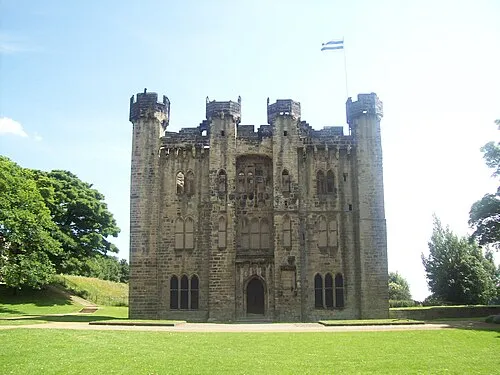 Hylton Castle Historic site, Sunderland2.7 km W
-
Tunstall Hills Mountain, Sunderland4 km S
-
Whitburn Landmark, South Tyneside4 km N
-
Souter Lighthouse Landmark, South Tyneside6.3 km NE
Sources & licences
Data last updated: · 2 independent sources