- Elevation
- 98 m
- above sea level
- Local time
- UTC+00:00
- Europe/London · UTC+00:00
- Airports
- CWL Cardiff International Airport109 km
- BRS Bristol Airport145 km
About Allt Gudd
Allt Gudd is a mountain. Location: Beulah, Ceredigion. Elevation: 98 m. The best months to visit are June–September. The nearest airport is Cardiff International Airport (109 km). Nearby sights include Ynys Fawr and Pen-rhiw-olau.
Photos of Allt Gudd
-
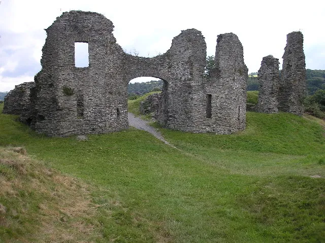
Newcastle Emlyn Castle Steve Chapple · CC BY-SA 2.0 -

Cilgerran Castle Waterborough · CC BY-SA 3.0


Climate of Allt Gudd
Best months for sightseeingBest months for sightseeing: June–September.
This month · November
A wet month
Day 10° · Night 6° · Rain 124 mm
- Hottest month
- August (day 18°)
- Coldest month
- February (night 3°)
- Wettest month
- November (124 mm)
- Driest month
- May (64 mm)
Bars: average monthly low and high temperature. Below: precipitation. Monthly averages for 1970–2000 at about 18 km resolution, adjusted for elevation. Highlighted months are mild and relatively dry. Source: WorldClim 2.1 (CC BY 4.0).
Show values as a table
| Month | Jan | Feb | Mar | Apr | May | Jun | Jul | Aug | Sep | Oct | Nov | Dec |
|---|---|---|---|---|---|---|---|---|---|---|---|---|
| Average high (°C) | 8° | 7° | 9° | 11° | 14° | 16° | 18° | 18° | 16° | 13° | 10° | 9° |
| Average low (°C) | 3° | 3° | 4° | 5° | 7° | 10° | 12° | 12° | 11° | 8° | 6° | 4° |
| Precipitation (mm) | 113 | 80 | 87 | 65 | 64 | 74 | 70 | 91 | 94 | 117 | 124 | 118 |
Other places to visit in this season: June July August September
How to get to Allt Gudd
The nearest airport is Cardiff International Airport (CWL), 109 km to the southeast as the crow flies. The nearest large city is Swansea, 62 km to the southeast.
Airports
- Cardiff International Airport (CWL) Cardiff 109 kmsoutheast
- Bristol Airport (BRS) Bristol 145 kmsoutheast
- Exeter International Airport (EXT) Exeter, Devon 166 kmsoutheast
Nearby large cities
- Swansea Population: 300.4K 62 kmsoutheast
- Cardiff Population: 372.1K 112 kmsoutheast
- Newport Population: 161.5K 117 kmsoutheast
- Bristol Population: 479K 148 kmsoutheast
- Telford Population: 155.6K 157 kmnortheast
Straight-line distances; road distances are longer. Airport data: OurAirports.
Day trips from Allt Gudd
Within 100 km: 466 historic and cultural sites, 1,667 natural sites, 164 lakes, rivers and coasts.
0–25 km171 places
- Poppit Sands Beach 14 kmNW
- Mwnt beach Beach 12 kmNW
- Tresaith Beach Beach 9 kmN
- Llangrannog's Beach Beach 13 kmN
25–60 km788 places
- St Justinian Natural site 58 kmW
- Porth Clais Natural site 56 kmW
- Port Selau Natural site 57 kmW
- Manorbier Beach Beach 50 kmSW
60–100 km1,338 places
- Whistling Sands Beach 88 kmN
- Traeth Penllech Beach 92 kmN
- Porth Towyn Beach Beach 95 kmN
- The Head Island 66 kmSW
Straight-line distances.
Nearest towns and villages
-
Cenarth Village, Beulah0.8 km SW
-
 Newcastle Emlyn Village, Llandyfriog3.9 km E
-
Capel Tygwydd Village, Beulah1.4 km N
-
Troed-y-rhiw-Siôn Village, Beulah1.4 km E
-
Pont Hirwaun Village, Beulah1.9 km NW
-
Brongwyn Village, Beulah2 km NE
Nearby attractions & nature
Everything nearby-
Ynys Fawr Island, Beulah0.8 km SW
-
Pen-rhiw-olau Mountain, Cenarth2.1 km S
-
Stradmore Motte Historic site, Beulah1.9 km W
-
Parc y Domen Issa Historic site, Cenarth0.9 km S
-
Scotland Hill Mountain, Beulah3.9 km NW
-
Afon Cych River, Wales2.9 km SW
-
Allt y Ddinas Mountain, Beulah4.6 km E
-
Pen Carreg-wen Mountain, Manordeifi5 km W
Sources & licences
Data last updated: