- Elevation
- 224 m
- above sea level
- Local time
- UTC+00:00
- Europe/London · UTC+00:00
- Places inside
- 8
- listed under Ystrad Meurig
- Airports
- CWL Cardiff International Airport107 km
- BRS Bristol Airport131 km
About Ystrad Meurig
Ystrad Meurig is a municipality. Location: Ceredigion, Wales. Elevation: 224 m. The best months to visit are June–August. The nearest airport is Cardiff International Airport (107 km). Nearby sights include Cwm Meurig Isaf and Pen Ty'n-llain.
Climate of Ystrad Meurig
Best months for sightseeingBest months for sightseeing: June–August.
This month · November
A wet month
Day 9° · Night 4° · Rain 182 mm
- Hottest month
- July (day 18°)
- Coldest month
- February (night 1°)
- Wettest month
- November (182 mm)
- Driest month
- May (85 mm)
Bars: average monthly low and high temperature. Below: precipitation. Monthly averages for 1970–2000 at about 18 km resolution, adjusted for elevation. Highlighted months are mild and relatively dry. Source: WorldClim 2.1 (CC BY 4.0).
Show values as a table
| Month | Jan | Feb | Mar | Apr | May | Jun | Jul | Aug | Sep | Oct | Nov | Dec |
|---|---|---|---|---|---|---|---|---|---|---|---|---|
| Average high (°C) | 7° | 6° | 8° | 11° | 14° | 16° | 18° | 18° | 16° | 13° | 9° | 7° |
| Average low (°C) | 2° | 1° | 2° | 3° | 6° | 9° | 11° | 11° | 9° | 7° | 4° | 2° |
| Precipitation (mm) | 173 | 123 | 140 | 97 | 85 | 101 | 101 | 121 | 133 | 164 | 182 | 182 |
How to get to Ystrad Meurig
The nearest airport is Cardiff International Airport (CWL), 107 km to the south as the crow flies. The nearest large city is Swansea, 74 km to the south.
Airports
- Cardiff International Airport (CWL) Cardiff 107 kmsouth
- Bristol Airport (BRS) Bristol 131 kmsoutheast
- Liverpool John Lennon Airport (LPL) Liverpool 137 kmnortheast
Nearby large cities
- Swansea Population: 300.4K 74 kmsouth
- Newport Population: 161.5K 101 kmsoutheast
- Cardiff Population: 372.1K 104 kmsoutheast
- Telford Population: 155.6K 109 kmnortheast
- Worcester Population: 101.7K 117 kmeast
Straight-line distances; road distances are longer. Airport data: OurAirports.
Day trips from Ystrad Meurig
Within 100 km: 880 historic and cultural sites, 2,587 natural sites, 206 lakes, rivers and coasts.
0–25 km334 places
- Pen-y-gareg Reservoir Lake 21 kmE
- Gareg-ddu Reservoir Lake 22 kmE
- Dol-y-mynach Reservoir Lake 23 kmE
- Craig-yr-allt gôch Reservoir Lake 20 kmE
25–60 km1,256 places
- Poppit Sands Beach 56 kmW
- Mwnt beach Beach 52 kmW
- Tresaith Beach Beach 44 kmSW
- Llangrannog's Beach Beach 40 kmW
60–100 km2,083 places
- Manorbier Beach Beach 94 kmSW
- Whistling Sands Beach 81 kmNW
- Traeth Penllech Beach 83 kmNW
- Porth Towyn Beach Beach 84 kmNW
Straight-line distances.
Places in Ystrad Meurig
8 placesCities & villages3
- Swyddffynnon · Village
- Tynygraig · Village
- Ystrad-Meurig · Village
Mountains & nature3
- Comins Pen-y-banc · Mountain
- Drysgol · Mountain
- Mynydd Bach · Mountain
Heritage & sights2
- Penycastell · Historic site
- Ystrad Meurig Castle · Historic site
Nearby attractions & nature
Everything nearby-
Cwm Meurig Isaf Historic site, Ystrad Fflur3.3 km E
-
Pen Ty'n-llain Mountain, Lledrod3.2 km NW
-
Castell Llwyn Gwinau Historic site, Tregaron4.2 km SW
-
Comins Pen-y-banc (old GR) Mountain, Lledrod3.7 km NW
-
Craig y Bwlch Mountain, Ysbyty Ystwyth4 km NE
-
Esgair-maen-fach Mountain, Tregaron4.4 km SW
-
Pen Bwlchyddwyallt Mountain, Ystrad Fflur4.7 km SE
-
Pen Blaengorffen Mountain, Ystrad Fflur5.3 km SE
Other cities and towns in Ceredigion
-
Trawsgoed Municipality, Ceredigion7.4 km N
-
Ystrad Fflur Municipality, Ceredigion8 km E
-
Llangwyryfon Municipality, Ceredigion8.2 km W
-
Llangeitho Municipality, Ceredigion9 km SW
-
Llanilar Municipality, Ceredigion9 km NW
-
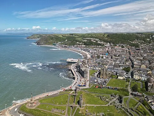 Aberystwyth Town, Aberystwyth18 km NW
Sources & licences
Data last updated: