Moosburg
Located in Politischer Bezirk Klagenfurt Land, Carinthia Coordinates: 46°40′04″ N 14°10′59″ E
- Population
- 4,513
- 4.5K
- Elevation
- 510 m
- above sea level
- Local time
- UTC+01:00
- Europe/Vienna · UTC+01:00
- Places inside
- 35
- listed under Moosburg
- Airports
- KLU Klagenfurt Airport12 km
- LJU Ljubljana Jože Pučnik Airport54 km
About Moosburg
Moosburg is a municipality. Location: Politischer Bezirk Klagenfurt Land, Carinthia. Population: 4,513. Elevation: 510 m. The best months to visit are May–September. The nearest airport is Klagenfurt Airport (12 km). Nearby sights include NDB.Funkfeuer KW and Hornstein.
Photos of Moosburg
-
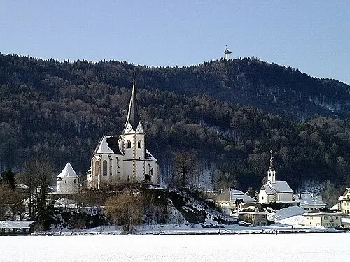
Pyramidenkogel Johann Jaritz · CC BY-SA 3.0 at -
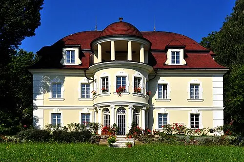
Lind Johann Jaritz · CC BY-SA 3.0 at -
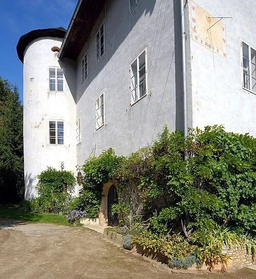
Hornstein Johann Jaritz · CC BY-SA 3.0 at


Climate of Moosburg
Best months for sightseeingBest months for sightseeing: May–September.
This month · November
A wet month
Day 7° · Night -1° · Rain 102 mm
- Hottest month
- July (day 25°)
- Coldest month
- January (night -6°)
- Wettest month
- July (142 mm)
- Driest month
- January (47 mm)
Bars: average monthly low and high temperature. Below: precipitation. Monthly averages for 1970–2000 at about 18 km resolution, adjusted for elevation. Highlighted months are mild and relatively dry. Source: WorldClim 2.1 (CC BY 4.0).
Show values as a table
| Month | Jan | Feb | Mar | Apr | May | Jun | Jul | Aug | Sep | Oct | Nov | Dec |
|---|---|---|---|---|---|---|---|---|---|---|---|---|
| Average high (°C) | 2° | 5° | 10° | 14° | 19° | 23° | 25° | 24° | 20° | 14° | 7° | 3° |
| Average low (°C) | -6° | -5° | -2° | 2° | 7° | 11° | 12° | 12° | 8° | 4° | -1° | -5° |
| Precipitation (mm) | 47 | 50 | 73 | 90 | 104 | 139 | 142 | 122 | 115 | 110 | 102 | 69 |
Other places to visit in this season: May June July August September
How to get to Moosburg
The nearest airport is Klagenfurt Airport (KLU), 12 km to the east as the crow flies. The nearest large city is Klagenfurt, 11 km to the southeast.
Airports
- Klagenfurt Airport (KLU) Klagenfurt am Wörthersee 12 kmeast
- Ljubljana Jože Pučnik Airport (LJU) Zgornji Brnik 54 kmsoutheast
- Graz Airport (GRZ) Feldkirchen bei Graz 102 kmeast
Nearby large cities
- Klagenfurt Population: 100.3K 11 kmsoutheast
- Ljubljana Population: 272.2K 73 kmsouth
- Graz Population: 303.3K 106 kmnortheast
- Rijeka Population: 108K 150 kmsouth
- Salzburg Population: 157.2K 153 kmnorthwest
Straight-line distances; road distances are longer. Airport data: OurAirports.
Day trips from Moosburg
Within 100 km: 203 historic and cultural sites, 1,864 natural sites, 666 lakes, rivers and coasts.
0–25 km211 places
- Wörthersee Lake 6 kmSW
- Lake Ossiach Lake 17 kmW
- Magdalenensee Lake 24 kmW
- Längsee Lake 23 kmNE
25–60 km737 places
- Lake Bohinj Lake 49 kmSW
- Lake Bled Lake 34 kmS
- Triglav Mountain 42 kmSW
- Rjavina Mountain 38 kmSW
60–100 km1,785 places
- Hoher Dachstein Mountain 100 kmNW
- Raša River 97 kmS
- Ribnica Lake Lake 85 kmE
- Šmarna gora Mountain 64 kmS
Straight-line distances.
Places in Moosburg
35 places- 1 Moosburg 1K
- 2 Sankt Peter 536
- 3 Tigring 461
- 4 Tuderschitz 310
- 5 Stallhofen 255
- 6 Seigbichl 240
- 7 Ratzenegg 174
- 8 Hohenfeld 123
- 9 Gradenegg 119
- 10 Knasweg 106
- 11 Bärendorf 84
- 12 Ameisbichl 77
- 13 Gabriel 71
- 14 Witsch 68
- 15 Untergöriach 65
- 16 Rosenau 60
- 17 Goritschitzen 57
- 18 Nußberg 54
- 19 Faning 53
- 20 Vögelitz 51
- 21 Windischbach 48
- 22 Obergöriach 45
- 23 Unterlinden 41
- 24 Malleberg 40
- 25 Prosintschach 39
- 26 Arlsdorf 38
- 27 Ziegelsdorf 37
- 28 Dellach 25
- 29 Wielen 22
- 30 Polan 20
- 31 Krainig 17
- 32 Simislau 13
- 33 Windischbach-Gegend 5
Bar: population relative to the most populous place in this list.
Cities & villages1
- Sankt Gandolf · Village
Mountains & nature1
- Freudenberg · Mountain
Nearby attractions & nature
Everything nearby-
NDB.Funkfeuer KW Landmark, Klagenfurt2.7 km E
-
Hornstein Historic site, Krumpendorf am Wörthersee4.6 km SE
-
Pyramidenkogel Mountain, Keutschach am See7.3 km SW
-
Zingelsberg Mountain, Feldkirchen in Kärnten5.2 km NW
-
Ruine Leonstein Historic site, Pörtschach am Wörthersee5.4 km SW
-
Lind Historic site, Klagenfurt7.9 km E
-
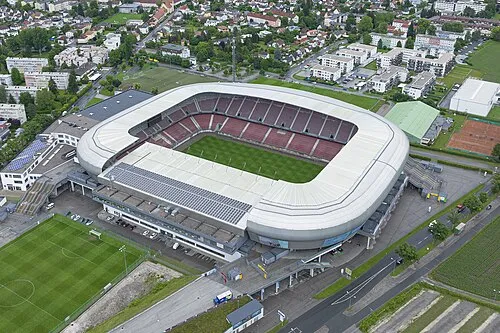 Wörthersee Stadion Landmark, Klagenfurt9.8 km SE
-
Hoher Gallin Mountain, Techelsberg am Wörther See6.4 km W
Sources & licences
Data last updated: