Hitzendorf
Located in Politischer Bezirk Graz-Umgebung, Styria Coordinates: 47°02′04″ N 15°18′16″ E
- Population
- 7,121
- 7.1K
- Elevation
- 384 m
- above sea level
- Local time
- UTC+01:00
- Europe/Vienna · UTC+01:00
- Places inside
- 28
- listed under Hitzendorf
- Airports
- GRZ Graz Airport11 km
- MBX Maribor Edvard Rusjan Airport68 km
About Hitzendorf
Hitzendorf is a municipality. Location: Politischer Bezirk Graz-Umgebung, Styria. Population: 7,121. Elevation: 384 m. The best months to visit are May–September. The nearest airport is Graz Airport (11 km). Nearby sights include Schloss Hart and Schloss Plankenwarth.
Climate of Hitzendorf
Best months for sightseeingBest months for sightseeing: May–September.
This month · November
A cold month
Day 8° · Night 0° · Rain 60 mm
- Hottest month
- July (day 25°)
- Coldest month
- January (night -5°)
- Wettest month
- July (129 mm)
- Driest month
- January (29 mm)
Bars: average monthly low and high temperature. Below: precipitation. Monthly averages for 1970–2000 at about 18 km resolution, adjusted for elevation. Highlighted months are mild and relatively dry. Source: WorldClim 2.1 (CC BY 4.0).
Show values as a table
| Month | Jan | Feb | Mar | Apr | May | Jun | Jul | Aug | Sep | Oct | Nov | Dec |
|---|---|---|---|---|---|---|---|---|---|---|---|---|
| Average high (°C) | 3° | 6° | 10° | 15° | 20° | 23° | 25° | 24° | 20° | 15° | 8° | 4° |
| Average low (°C) | -5° | -4° | 0° | 4° | 9° | 12° | 14° | 13° | 10° | 5° | 0° | -3° |
| Precipitation (mm) | 29 | 37 | 55 | 61 | 89 | 121 | 129 | 122 | 89 | 72 | 60 | 44 |
Other places to visit in this season: May June July August September
How to get to Hitzendorf
The nearest airport is Graz Airport (GRZ), 11 km to the southeast as the crow flies. The nearest large city is Graz, 11 km to the east.
Airports
- Graz Airport (GRZ) Feldkirchen bei Graz 11 kmsoutheast
- Maribor Edvard Rusjan Airport (MBX) Maribor 68 kmsoutheast
- Klagenfurt Airport (KLU) Klagenfurt am Wörthersee 86 kmsouthwest
Nearby large cities
- Graz Population: 303.3K 11 kmeast
- Klagenfurt Population: 100.3K 89 kmsouthwest
- Zagreb Population: 663.6K 145 kmsouth
- Linz Population: 204.8K 161 kmnorthwest
- Győr Population: 129.3K 190 kmnortheast
Straight-line distances; road distances are longer. Airport data: OurAirports.
Day trips from Hitzendorf
Within 100 km: 257 historic and cultural sites, 1,621 natural sites, 560 lakes, rivers and coasts.
0–25 km220 places
- Thaler See Lake 6 kmNE
- Wundschuher Teich Lake 16 kmSE
- Poniglteich Lake 17 kmSE
- Neuteich Lake 15 kmSE
25–60 km740 places
- Wildsee Lake 55 kmW
- Waldteiche Lake 34 kmE
- Großer Winterleitensee Lake 58 kmW
- Lindersee Lake 56 kmW
60–100 km1,478 places
- Klamm Natural site 92 kmNW
- Treffnersee Lake 80 kmNW
- Glohbuckensee Lake 87 kmNW
- Gemeinsee Lake 84 kmNW
Straight-line distances.
Places in Hitzendorf
28 places- 1 Hitzendorf 1.1K
- 2 Rohrbach 833
- 3 Steinberg 679
- 4 Mantscha 467
- 5 Berndorf 436
- 6 Attendorf 362
- 7 Niederberg 332
- 8 Stein 325
- 9 Oberberg 318
- 10 Attendorfberg 310
- 11 Altreiteregg 246
- 12 Höllberg 231
- 13 Neureiteregg 226
- 14 Riederhof 213
- 15 Holzberg 196
- 16 Mayersdorf 178
- 17 Doblegg 157
- 18 Mühlriegl 129
- 19 Altenberg 125
- 20 Schadendorfberg 80
- 21 Pirka 70
- 22 Södingberg 54
Bar: population relative to the most populous place in this list.
Cities & villages4
- Höchstriegel · Village
- Kölberg · Village
- Mur · Village
- Neudorf · Village
Mountains & nature1
- Buchkogel · Mountain
Heritage & sights1
- Rudolfswarte · Landmark
Nearby attractions & nature
Everything nearby-
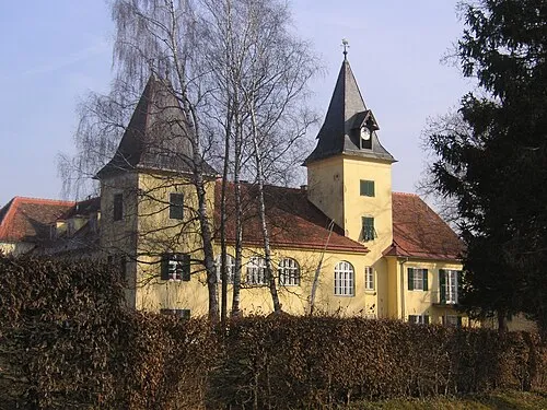 Schloss Hart Historic site, Thal3.9 km NE
-
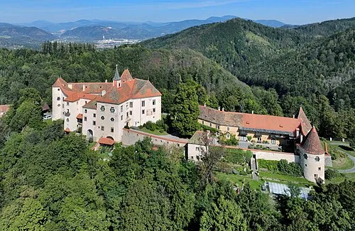 Schloss Plankenwarth Historic site, Sankt Oswald bei Plankenwarth5.4 km N
-
Brühwald Natural site, Styria4.2 km NE
-
Kreuzeck Mountain, Sankt Bartholomä4.6 km NW
-
Blasenberg Mountain, Seiersberg-Pirka5.1 km SE
-
Bockkogel Mountain, Seiersberg-Pirka5.1 km SE
-
Stocker Wald Natural site, Styria5 km NE
-
Sankt Johann und Paul Attraction, Wetzelsdorf5 km E
Sources & licences
Data last updated: