Borilovići
Located in Republika Srpska, Bosnia and Herzegovina Coordinates: 42°46′22″ N 18°22′27″ E
- Elevation
- 620 m
- above sea level
- Local time
- UTC+01:00
- Europe/Sarajevo · UTC+01:00
- Airports
- DBV Dubrovnik Ruđer Bošković Airport25 km
- TIV Tivat Airport50 km
About Borilovići
Borilovići is a village. Location: Republika Srpska, Bosnia and Herzegovina. Elevation: 620 m. The best months to visit are May–September. The nearest airport is Dubrovnik Ruđer Bošković Airport (25 km). Nearby sights include Trebinjsko Jezero and Sniježnica.
Photos of Borilovići
-

Trebinjsko Jezero Zdravko Sumic at Serbian Wikipedia · Public domain

Climate of Borilovići
Best months for sightseeingBest months for sightseeing: May–September.
This month · November
A wet month
Day 12° · Night 5° · Rain 166 mm
- Hottest month
- July (day 27°)
- Coldest month
- February (night 1°)
- Wettest month
- November (166 mm)
- Driest month
- July (43 mm)
Bars: average monthly low and high temperature. Below: precipitation. Monthly averages for 1970–2000 at about 18 km resolution, adjusted for elevation. Highlighted months are mild and relatively dry. Source: WorldClim 2.1 (CC BY 4.0).
Show values as a table
| Month | Jan | Feb | Mar | Apr | May | Jun | Jul | Aug | Sep | Oct | Nov | Dec |
|---|---|---|---|---|---|---|---|---|---|---|---|---|
| Average high (°C) | 8° | 8° | 12° | 15° | 20° | 24° | 27° | 27° | 22° | 18° | 12° | 9° |
| Average low (°C) | 1° | 1° | 3° | 6° | 11° | 14° | 17° | 16° | 13° | 9° | 5° | 2° |
| Precipitation (mm) | 119 | 110 | 97 | 102 | 78 | 64 | 43 | 57 | 99 | 135 | 166 | 149 |
Other places to visit in this season: May June July August September
How to get to Borilovići
The nearest airport is Dubrovnik Ruđer Bošković Airport (DBV), 25 km to the south as the crow flies. The nearest large city is Mostar, 78 km to the northwest.
Airports
- Dubrovnik Ruđer Bošković Airport (DBV) Dubrovnik 25 kmsouth
- Tivat Airport (TIV) Tivat 50 kmsoutheast
- Mostar International Airport (OMO) Mostar 71 kmnorthwest
Nearby large cities
- Mostar Population: 104.5K 78 kmnorthwest
- Podgorica Population: 236.9K 82 kmsoutheast
- Sarajevo Population: 696.7K 120 kmnorth
- Zenica Population: 164.4K 163 kmnorth
- Split Population: 149.8K 177 kmnorthwest
Straight-line distances; road distances are longer. Airport data: OurAirports.
Day trips from Borilovići
Within 100 km: 12 historic and cultural sites, 83 natural sites, 71 lakes, rivers and coasts.
0–25 km10 places
- Sniježnica Mountain 22 kmS
- Međeđa Natural site 18 kmS
- Velika Jastrebica Mountain 24 kmSE
- Bijela Gora Mountain 23 kmSE
25–60 km65 places
- Česvinica Mountain 53 kmW
- Zec Mountain 52 kmW
- Kosor Mountain 55 kmW
- Saint Ignatius Church Attraction 26 kmSW
60–100 km91 places
- Mljet Island 68 kmW
- Bobotov Kuk Mountain 67 kmNE
- Durmitor Mountain 67 kmNE
- Vrtijeljka Mountain 65 kmSE
Straight-line distances.
Nearby attractions & nature
Everything nearby-
Trebinjsko Jezero Lake, Republika Srpska7.7 km S
-
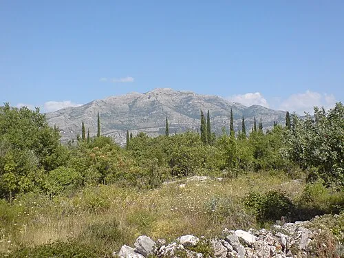 Sniježnica Mountain, Dubrovnik-Neretva County22 km S
-
 Bilećko Jezero Lake, Bosnia and Herzegovina8.3 km NE
-
Borova Mountain, Republika Srpska13 km SE
-
Dubovac Natural site, Republika Srpska17 km SE
-
Bjelasnica Mountain, Republika Srpska22 km W
Other cities and towns in Republika Srpska


Sources & licences
Data last updated: