Municipality of Gornja Rijeka
Located in Koprivnica-Križevci County, Croatia Coordinates: 46°06′35″ N 16°23′27″ E
- Population
- 1,559
- 1.6K
- Elevation
- 204 m
- above sea level
- Local time
- UTC+01:00
- Europe/Zagreb · UTC+01:00
- Places inside
- 1
- listed under Municipality of Gornja Rijeka
- Airports
- ZAG Zagreb Franjo Tuđman International Airport48 km
- MBX Maribor Edvard Rusjan Airport68 km
About Municipality of Gornja Rijeka
Municipality of Gornja Rijeka is a district. Location: Koprivnica-Križevci County, Croatia. Population: 1,559. The best months to visit are May–September. The nearest airport is Zagreb Franjo Tuđman International Airport (48 km). Nearby sights include Kalnik and Kalnik.
Photos of Municipality of Gornja Rijeka
-

Kalnik SpeedyGonsales · CC BY-SA 3.0

Climate of Municipality of Gornja Rijeka
Best months for sightseeingBest months for sightseeing: May–September.
This month · November
A cold month
Day 9° · Night 2° · Rain 82 mm
- Hottest month
- July (day 26°)
- Coldest month
- January (night -3°)
- Wettest month
- June (97 mm)
- Driest month
- January (44 mm)
Bars: average monthly low and high temperature. Below: precipitation. Monthly averages for 1970–2000 at about 18 km resolution, adjusted for elevation. Highlighted months are mild and relatively dry. Source: WorldClim 2.1 (CC BY 4.0).
Show values as a table
| Month | Jan | Feb | Mar | Apr | May | Jun | Jul | Aug | Sep | Oct | Nov | Dec |
|---|---|---|---|---|---|---|---|---|---|---|---|---|
| Average high (°C) | 3° | 6° | 11° | 16° | 21° | 24° | 26° | 26° | 21° | 15° | 9° | 4° |
| Average low (°C) | -3° | -2° | 1° | 5° | 10° | 13° | 15° | 14° | 10° | 6° | 2° | -2° |
| Precipitation (mm) | 44 | 45 | 55 | 66 | 76 | 97 | 83 | 84 | 81 | 81 | 82 | 62 |
Other places to visit in this season: May June July August September
How to get to Municipality of Gornja Rijeka
The nearest airport is Zagreb Franjo Tuđman International Airport (ZAG), 48 km to the southwest as the crow flies. The nearest large city is Zagreb, 46 km to the southwest.
Airports
- Zagreb Franjo Tuđman International Airport (ZAG) Velika Gorica 48 kmsouthwest
- Maribor Edvard Rusjan Airport (MBX) Maribor 68 kmnorthwest
- Hévíz–Balaton Airport (SOB) Sármellék 87 kmnortheast
Nearby large cities
- Zagreb Population: 663.6K 46 kmsouthwest
- Graz Population: 303.3K 129 kmnorthwest
- Pécs Population: 145.3K 142 kmeast
- Ljubljana Population: 272.2K 146 kmwest
- Banja Luka Population: 221.1K 161 kmsoutheast
Straight-line distances; road distances are longer. Airport data: OurAirports.
Day trips from Municipality of Gornja Rijeka
Within 100 km: 34 historic and cultural sites, 114 natural sites, 131 lakes, rivers and coasts.
0–25 km6 places
- Kamešnica Potok River 8 kmE
- Lake Varaždin Lake 23 kmN
- Kalnik Mountain 6 kmNE
- Ivanšćica Mountain 22 kmNW
25–60 km40 places
- Kašina River 32 kmS
- Ledava River 44 kmN
- Ščavnica River 46 kmN
- Lake Ptuj Lake 49 kmNW
60–100 km233 places
- Ribnica Lake Lake 97 kmNW
- Pohorje Mountain 85 kmNW
- Krka River 66 kmW
- Jezero Pernica Lake 74 kmNW
Straight-line distances.
Places in Municipality of Gornja Rijeka
1 placeBar: population relative to the most populous place in this list.
Nearby attractions & nature
Everything nearby-
Kalnik Mountain, Varaždin County5.6 km NE
-
Kalnik Mountain, Croatia10 km NE
-
Kamešnica Potok River, Croatia8.4 km E
-
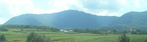 Ivanšćica Mountain, Varaždin County22 km NW
-
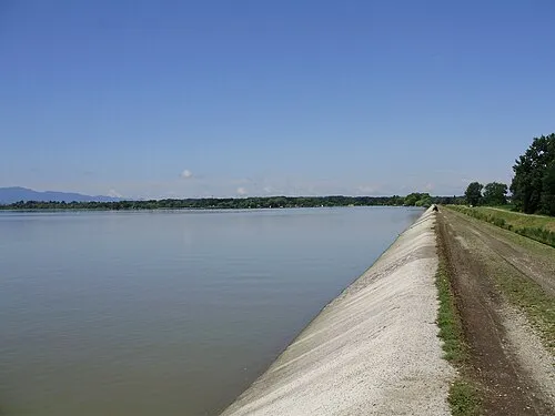 Lake Varaždin Lake, Croatia23 km N
-
Ivanscica Mountain, Town of Ivanec22 km W
Other regions in Koprivnica-Križevci County
-
 Municipality of Sveti Petar Orehovec District, Koprivnica-Križevci County5.8 km SE
-
Municipality of Kalnik District, Koprivnica-Križevci County6 km E
-
 Town of Križevci District, Koprivnica-Križevci County16 km SE
-
 Municipality of Sokolovac District, Koprivnica-Križevci County25 km E
-
Municipality of Rasinja District, Koprivnica-Križevci County26 km E
-
Municipality of Sveti Ivan Žabno District, Koprivnica-Križevci County25 km SE
Sources & licences
Data last updated: