Hreljin
Located in Town of Bakar, Primorje-Gorski Kotar County Coordinates: 45°16′57″ N 14°35′57″ E

- Population
- 2,139
- 2.1K
- Elevation
- 290 m
- above sea level
- Local time
- UTC+01:00
- Europe/Zagreb · UTC+01:00
- Airports
- RJK Rijeka Airport8 km
- PUY Pula Airport69 km
About Hreljin
Hreljin is a village. Location: Town of Bakar, Primorje-Gorski Kotar County. Population: 2,139. Elevation: 290 m.
Hreljin is a village in western Croatia, just southeast of Bakar and northeast of Kraljevica, above Bay of Bakar (Croatian: Bakarski zaljev). Hreljin administratively belongs to the city of Bakar, situated in Primorje-Gorski Kotar County - Primorsko-goranska županija.
Source: Wikipedia · CC BY-SA 4.0
At a glance
- Area
- 35.1 km²
Source: Wikidata
Photos of Hreljin
-

Fortepan — ID 86924 : Adományozó/Donor: Magyar Földrajzi Múzeum / Erdélyi Mór cége. archive copy at the Wayback Machine · Public domain -

Branimirović · CC BY-SA 4.0 -

MickMorton · CC0 -

Tuhobić Martin Brož · CC BY 3.0 -

Krk Bridge Zoran Knez · Public domain


Climate of Hreljin
Best months for sightseeingBest months for sightseeing: May–September.
This month · November
A wet month
Day 12° · Night 5° · Rain 171 mm
- Hottest month
- July (day 26°)
- Coldest month
- January (night 1°)
- Wettest month
- November (171 mm)
- Driest month
- July (68 mm)
Bars: average monthly low and high temperature. Below: precipitation. Monthly averages for 1970–2000 at about 18 km resolution, adjusted for elevation. Highlighted months are mild and relatively dry. Source: WorldClim 2.1 (CC BY 4.0).
Show values as a table
| Month | Jan | Feb | Mar | Apr | May | Jun | Jul | Aug | Sep | Oct | Nov | Dec |
|---|---|---|---|---|---|---|---|---|---|---|---|---|
| Average high (°C) | 7° | 8° | 11° | 15° | 20° | 24° | 26° | 26° | 22° | 17° | 12° | 8° |
| Average low (°C) | 1° | 1° | 3° | 6° | 11° | 14° | 17° | 16° | 13° | 9° | 5° | 2° |
| Precipitation (mm) | 106 | 90 | 97 | 102 | 95 | 109 | 68 | 91 | 141 | 170 | 171 | 136 |
Other places to visit in this season: May June July August September
How to get to Hreljin
The nearest airport is Rijeka Airport (RJK), 8 km to the south as the crow flies. The nearest large city is Rijeka, 13 km to the west.
Airports
- Rijeka Airport (RJK) Rijeka(Omišalj) 8 kmsouth
- Pula Airport (PUY) Pula 69 kmsouthwest
- Ljubljana Jože Pučnik Airport (LJU) Zgornji Brnik 105 kmnorth
Nearby large cities
- Rijeka Population: 108K 13 kmwest
- Ljubljana Population: 272.2K 86 kmnorth
- Zagreb Population: 663.6K 123 kmnortheast
- Klagenfurt Population: 100.3K 151 kmnorth
- Graz Population: 303.3K 209 kmnorth
Straight-line distances; road distances are longer. Airport data: OurAirports.
Day trips from Hreljin
Within 100 km: 11 historic and cultural sites, 77 natural sites, 70 lakes, rivers and coasts.
0–25 km10 places
- Krk Island 23 kmS
- Uvala Stipanja Natural site 16 kmS
- Viševica Mountain 16 kmE
- Risnjak Mountain 17 kmN
25–60 km25 places
- Otočić Košljun Island 29 kmS
- Veliki Snežnik Mountain 35 kmN
- Mala Gora Mountain 55 kmN
- Javorniki Mountain 56 kmNW
60–100 km123 places
- Lošinj Island 79 kmS
- Otok Ilovik Island 92 kmS
- Otočić Srakane Vele Island 81 kmS
- Raša River 81 kmNW
Straight-line distances.
Nearby attractions & nature
Everything nearby-
Krk Bridge Landmark, Primorje-Gorski Kotar County4.5 km SW
-
Tuhobić Mountain, Primorje-Gorski Kotar County6.7 km NE
-
 Rjecina River River, Primorje-Gorski Kotar County13 km W
-
Burni bitoraj - Vrh Bitoraj Mountain, Primorje-Gorski Kotar County15 km E
-
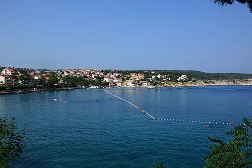 Uvala Stipanja Natural site, Primorje-Gorski Kotar County16 km S
-
Viševica Mountain, Primorje-Gorski Kotar County16 km E
Other cities and towns in Town of Bakar
-
 Škrljevo Village, Town of Bakar6.7 km NW
-
 Kukuljanovo Village, Town of Bakar8.2 km NW
Sources & licences
Data last updated: · 2 independent sources