Sestrunj
Located in Municipality of Preko, Zadar County Coordinates: 44°09′08″ N 15°00′04″ E
- Population
- 45
- 45
- Elevation
- 94 m
- above sea level
- Local time
- UTC+01:00
- Europe/Zagreb · UTC+01:00
- Airports
- ZAD Zadar Airport29 km
- PUY Pula Airport119 km
About Sestrunj
Sestrunj is a village. Location: Municipality of Preko, Zadar County. Population: 45. Elevation: 94 m. The best months to visit are May–October. The nearest airport is Zadar Airport (29 km). Nearby sights include Otok Sestrunj and Otok Rivanj.
Photos of Sestrunj
-
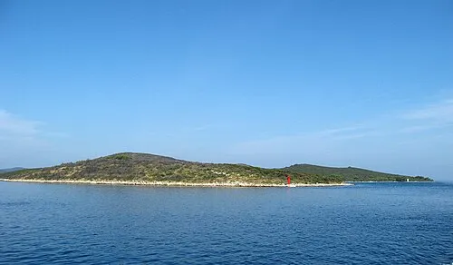
Otok Sestrunj Andres rus · CC BY-SA 3.0 -
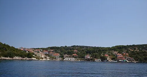
Otok Žverinac Mich973 · CC BY-SA 4.0 -

Otok Rivanj edited by M.Minderhoud · Public domain


Climate of Sestrunj
Best months for sightseeingBest months for sightseeing: May–October.
This month · November
A wet month
Day 14° · Night 7° · Rain 101 mm
- Hottest month
- July (day 28°)
- Coldest month
- February (night 3°)
- Wettest month
- October (102 mm)
- Driest month
- July (29 mm)
Bars: average monthly low and high temperature. Below: precipitation. Monthly averages for 1970–2000 at about 18 km resolution, adjusted for elevation. Highlighted months are mild and relatively dry. Source: WorldClim 2.1 (CC BY 4.0).
Show values as a table
| Month | Jan | Feb | Mar | Apr | May | Jun | Jul | Aug | Sep | Oct | Nov | Dec |
|---|---|---|---|---|---|---|---|---|---|---|---|---|
| Average high (°C) | 10° | 11° | 13° | 16° | 21° | 25° | 28° | 28° | 24° | 19° | 14° | 11° |
| Average low (°C) | 3° | 3° | 5° | 8° | 12° | 16° | 18° | 18° | 15° | 11° | 7° | 4° |
| Precipitation (mm) | 72 | 60 | 62 | 66 | 62 | 52 | 29 | 49 | 95 | 102 | 101 | 90 |
Other places to visit in this season: May June July August September October
How to get to Sestrunj
The nearest airport is Zadar Airport (ZAD), 29 km to the east as the crow flies. The nearest large city is Split, 136 km to the southeast.
Airports
- Zadar Airport (ZAD) Zadar 29 kmeast
- Pula Airport (PUY) Pula 119 kmnorthwest
- Rijeka Airport (RJK) Rijeka(Omišalj) 123 kmnorth
Nearby large cities
- Split Population: 149.8K 136 kmsoutheast
- Rijeka Population: 108K 138 kmnorth
- Zagreb Population: 663.6K 200 kmnorth
- Ljubljana Population: 272.2K 215 kmnorth
- Klagenfurt Population: 100.3K 280 kmnorth
Straight-line distances; road distances are longer. Airport data: OurAirports.
Day trips from Sestrunj
Within 100 km: 8 historic and cultural sites, 18 natural sites, 67 lakes, rivers and coasts.
0–25 km15 places
- Otok Sestrunj Island 2 kmNW
- Otok Žverinac Island 7 kmW
- Otočić Ošljak Island 18 kmSE
- Otočić Mišjak Island 22 kmNE
25–60 km32 places
- Silba Island 35 kmNW
- Otok Ilovik Island 49 kmNW
- Otok Premuda Island 36 kmNW
- Kornat Island 44 kmSE
60–100 km46 places
- Lošinj Island 68 kmNW
- Otok Prvić Island 79 kmSE
- Otok Zlarin Island 85 kmSE
- Otok Kaprije Island 76 kmSE
Straight-line distances.
Nearby attractions & nature
Everything nearby-
Otok Sestrunj Island, Zadar County2.2 km NW
-
Otok Rivanj Island, Zadar County2.9 km E
-
Otok Žverinac Island, Zadar County6.8 km W
-
Otok Tun Veli Island, Zadar County7.5 km NW
-
 Otok Iž Island, Zadar County15 km SE
-
 Otok Rava Island, Zadar County15 km S
Sources & licences
Data last updated: