Vračovice
Located in Vračovice-Orlov, Ústí nad Orlicí District Coordinates: 49°57′12″ N 16°15′07″ E

- Population
- 153
- 153
- Elevation
- 299 m
- above sea level
- Local time
- UTC+01:00
- Europe/Prague · UTC+01:00
- Airports
- PED Pardubice Airport37 km
- BRQ Brno-Tuřany Airport95 km
About Vračovice
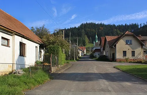
Vračovice is a village. Location: Vračovice-Orlov, Ústí nad Orlicí District. Population: 153. Elevation: 299 m. The best months to visit are May–September. The nearest airport is Pardubice Airport (37 km). Nearby sights include Zahořanský Kopec and Havranův kopec.
At a glance
- Area
- 2.2 km²
Source: Wikidata
Photos of Vračovice
-

Petr1888 · CC BY-SA 4.0 -

Petr1888 · CC BY-SA 4.0 -

Palickap · CC BY-SA 4.0 -

Palickap · CC BY-SA 4.0


Population of Vračovice over time
| 1900 | 134 | |
|---|---|---|
| 1910 | 131 | |
| 1921 | 118 | |
| 1930 | 126 | |
| 1950 | 90 | |
| 1961 | 86 | |
| 1970 | 82 | |
| 1980 | 88 | |
| 1991 | 86 | |
| 2001 | 78 | |
| 2011 | 88 | |
| 2021 | 73 |
Censuses and official estimates; source: Wikidata.
Climate of Vračovice
Best months for sightseeingBest months for sightseeing: May–September.
This month · November
A cold month
Day 6° · Night 1° · Rain 34 mm
- Hottest month
- August (day 24°)
- Coldest month
- January (night -4°)
- Wettest month
- June (81 mm)
- Driest month
- January (21 mm)
Bars: average monthly low and high temperature. Below: precipitation. Monthly averages for 1970–2000 at about 18 km resolution, adjusted for elevation. Highlighted months are mild and relatively dry. Source: WorldClim 2.1 (CC BY 4.0).
Show values as a table
| Month | Jan | Feb | Mar | Apr | May | Jun | Jul | Aug | Sep | Oct | Nov | Dec |
|---|---|---|---|---|---|---|---|---|---|---|---|---|
| Average high (°C) | 1° | 3° | 8° | 13° | 19° | 22° | 23° | 24° | 19° | 13° | 6° | 2° |
| Average low (°C) | -4° | -4° | 0° | 3° | 8° | 10° | 12° | 12° | 9° | 5° | 1° | -2° |
| Precipitation (mm) | 21 | 21 | 27 | 34 | 59 | 81 | 80 | 63 | 43 | 33 | 34 | 27 |
Other places to visit in this season: May June July August September
How to get to Vračovice
The nearest airport is Pardubice Airport (PED), 37 km to the west as the crow flies. The nearest large city is Brno, 88 km to the south.
Airports
- Pardubice Airport (PED) Pardubice 37 kmwest
- Brno-Tuřany Airport (BRQ) Brno 95 kmsouth
- Copernicus Wrocław Airport (WRO) Wrocław 136 kmnorth
Nearby large cities
- Brno Population: 404.3K 88 kmsouth
- Prague Population: 1.2M 132 kmwest
- Bratislava Population: 423.7K 210 kmsouth
- Dresden Population: 564.9K 216 kmnorthwest
- Linz Population: 204.8K 233 kmsouthwest
Straight-line distances; road distances are longer. Airport data: OurAirports.
Day trips from Vračovice
Within 100 km: 42 historic and cultural sites, 782 natural sites.
0–25 km24 places
- Zahořanský Kopec Mountain 6 kmSW
- Velká Suchá Mountain 24 kmNE
- Šuráňkův Kopec Mountain 7 kmE
- Palice Mountain 19 kmE
25–60 km171 places
- Sucha Kopa Mountain 59 kmNE
- Úsobrnka Natural site 57 kmSE
- Goworek Mountain 48 kmNE
- Ptak Mountain 57 kmN
60–100 km629 places
- Královský vršek Mountain 77 kmSW
- Bielec Mountain 100 kmN
- Parkowa Mountain 100 kmN
- Seč Mountain 99 kmSW
Straight-line distances.
Nearby attractions & nature
Everything nearby-
Zahořanský Kopec Mountain, Cerekvice nad Loučnou5.6 km SW
-
Havranův kopec Mountain, Sedliště5.8 km S
-
Bousovka Mountain, Bohuňovice6.1 km S
-
U Končin Mountain, Litomyšl6.9 km SE
-
 Podhoří Mountain, Orlické Podhůří8.8 km NE
-
Šuráňkův Kopec Mountain, Sloupnice7.4 km E
Sources & licences
Data last updated: · 2 independent sources