Arrondissement of Lons-le-Saunier
Located in Jura, Bourgogne-Franche-Comté Coordinates: 46°38′10″ N 5°36′01″ E
- Population
- 104,261
- 104.3K
- Elevation
- 374 m
- above sea level
- Local time
- UTC+01:00
- Europe/Paris · UTC+01:00
- Places inside
- 248
- listed under Arrondissement of Lons-le-Saunier
- Airports
- DLE Dole Tavaux Airport47 km
- GVA Geneva International Airport59 km
About Arrondissement of Lons-le-Saunier
Arrondissement of Lons-le-Saunier is a municipality. Location: Jura, Bourgogne-Franche-Comté. Population: 104,261. Elevation: 374 m. The best months to visit are June–September. The nearest airport is Dole Tavaux Airport (47 km). Nearby sights include Bois du Chanois and Bois du Chaumois.
Photos of Arrondissement of Lons-le-Saunier
-
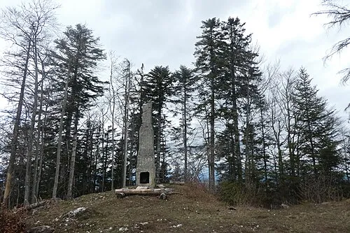
Mont de Saint-Sorlin Pmau · CC BY-SA 4.0

Climate of Arrondissement of Lons-le-Saunier
Best months for sightseeingBest months for sightseeing: June–September.
This month · November
A wet month
Day 9° · Night 3° · Rain 114 mm
- Hottest month
- July (day 24°)
- Coldest month
- January (night -1°)
- Wettest month
- November (114 mm)
- Driest month
- March (81 mm)
Bars: average monthly low and high temperature. Below: precipitation. Monthly averages for 1970–2000 at about 18 km resolution, adjusted for elevation. Highlighted months are mild and relatively dry. Source: WorldClim 2.1 (CC BY 4.0).
Show values as a table
| Month | Jan | Feb | Mar | Apr | May | Jun | Jul | Aug | Sep | Oct | Nov | Dec |
|---|---|---|---|---|---|---|---|---|---|---|---|---|
| Average high (°C) | 5° | 7° | 11° | 14° | 19° | 22° | 24° | 24° | 20° | 15° | 9° | 5° |
| Average low (°C) | -1° | 0° | 2° | 5° | 9° | 12° | 14° | 14° | 11° | 8° | 3° | 0° |
| Precipitation (mm) | 98 | 94 | 81 | 95 | 111 | 106 | 88 | 82 | 110 | 113 | 114 | 105 |
Other places to visit in this season: June July August September
How to get to Arrondissement of Lons-le-Saunier
The nearest airport is Dole Tavaux Airport (DLE), 47 km to the north as the crow flies. For international flights: Geneva International Airport (GVA) (59 km). The nearest large city is Geneva, 64 km to the southeast.
Airports
- Dole Tavaux Airport (DLE) Dole 47 kmnorth
- Geneva International Airport (GVA) Geneva 59 kmsoutheast
- Annecy Meythet airport (NCY) Annecy 88 kmsoutheast
Nearby large cities
- Geneva Population: 201.7K 64 kmsoutheast
- Besançon Population: 128.4K 75 kmnortheast
- Lausanne Population: 139.1K 80 kmeast
- Dijon Population: 159.9K 88 kmnorthwest
- Villeurbanne Population: 131.4K 112 kmsouthwest
Straight-line distances; road distances are longer. Airport data: OurAirports.
Day trips from Arrondissement of Lons-le-Saunier
Within 100 km: 207 historic and cultural sites, 540 natural sites, 218 lakes, rivers and coasts.
0–25 km38 places
- Lac de la Motte Lake 23 kmE
- Grand Lac Lake 14 kmSE
- Lac de Chalain Lake 15 kmE
- Lac de Vouglans Lake 18 kmS
25–60 km230 places
- Lac de Joux Lake 53 kmE
- Lac Brenet Lake 55 kmE
- Lac Aubonne Lake 60 kmE
- Lac Ter Lake 53 kmE
60–100 km697 places
- Lake Leman Lake 70 kmE
- Lac des Taillères Lake 83 kmNE
- Etang du Moulin de Vert Lake 60 kmSE
- Lac de Brêt Lake 91 kmE
Straight-line distances.
Arrondissement of Lons-le-Saunier and similar cities
Side by side with cities of similar size in the same country: population, elevation and climate.
| Measure | Arrondissement of Lons-le-Saunier | Nancy | Argenteuil | Boulogne-Billancourt |
|---|---|---|---|---|
| Population | 104.3K | 105.1K | 101.5K | 108.8K |
| Elevation | 374 m | 212 m | 37 m | 35 m |
| Summer day (hottest month) | 24° | 24° | 25° | 25° |
| Winter night (coldest month) | -1° | -1° | 2° | 2° |
| Annual rainfall | 1,197 mm | 789 mm | 632 mm | 632 mm |
| Best months | Jun–Sep | Jun–Sep | May–Sep | May–Sep |
| Distance | — | 232 km | 359 km | 351 km |
Climate values are 1970–2000 monthly averages; straight-line distance.
Places in Arrondissement of Lons-le-Saunier
248 places- 1 Lons-le-Saunier 17.4K
- 2 Champagnole 7.9K
- 3 Montmorot 3K
- 4 Saint-Amour 2.4K
- 5 Orgelet 1.6K
- 6 Perrigny 1.5K
- 7 Clairvaux-les-Lacs 1.4K
- 8 Bletterans 1.4K
- 9 Beaufort-Orbagna 1.3K
- 10 Cousance 1.3K
- 11 Arlay 1.2K
- 12 Domblans 1.2K
- 13 Arinthod 1.1K
- 14 Courlaoux 1.1K
- 15 Foncine-le-Haut 1.1K
- 16 Macornay 980
- 17 Hauteroche 942
- 18 Courlans 930
- 19 Val-Sonnette 912
- 20 Thoirette-Coisia 870
- 21 Commenailles 869
- 22 Messia-sur-Sorne 842
- 23 Mignovillard 804
- 24 Val Suran 797
- 25 Cize 785
- 26 Les Trois-Châteaux 772
- 27 Sellières 756
- 28 Voiteur 748
- 29 Ruffey-sur-Seille 722
- 30 Villevieux 713
- 31 Conliège 673
- 32 Chilly-le-Vignoble 671
- 33 Crotenay 654
- 34 Pont-de-Poitte 653
- 35 Aromas 650
- 36 Chapelle-Voland 608
- 37 La Chailleuse 604
- 38 Larnaud 599
- 39 Courbouzon 587
- 40 Équevillon 582
- 41 Ney 566
- 42 L'Étoile 559
- 43 Sirod 533
- 44 Plainoiseau 529
- 45 Andelot-en-Montagne 528
- 46 Montain 518
- 47 Nance 511
- 48 Montrond 493
- 49 Valzin en Petite Montagne 493
- 50 Chaumergy 487
- 51 Pannessières 481
- 52 Desnes 475
- 53 Trenal 461
- 54 Gevingey 453
- 55 Montaigu 451
- 56 Mantry 449
- 57 Nozeroy 436
- 58 Saint-Hymetière-sur-Valouse 434
- 59 Saint-Germain-en-Montagne 423
- 60 Chaux-des-Crotenay 406
Bar: population relative to the most populous place in this list.
Nearby attractions & nature
Everything nearby-
Bois du Chanois Natural site, Jura6.2 km S
-
Bois du Chaumois Natural site, Jura8.3 km NE
-
Syrène River, Jura9.2 km SE
-
Bois de Châtillon Natural site, Jura11 km E
-
Grand Lac Lake, Jura14 km SE
-
Bois de Malmont Natural site, Jura17 km S
-
Forêt du Chanet Natural site, Jura17 km NE
-
Forêt de l'Heute Natural site, Jura18 km NE
Sources & licences
Data last updated: