Arrondissement of Dole
Located in Jura, Bourgogne-Franche-Comté Coordinates: 47°00′28″ N 5°36′58″ E
- Population
- 106,061
- 106.1K
- Elevation
- 210 m
- above sea level
- Local time
- UTC+01:00
- Europe/Paris · UTC+01:00
- Places inside
- 189
- listed under Arrondissement of Dole
- Airports
- DLE Dole Tavaux Airport15 km
- GVA Geneva International Airport94 km
About Arrondissement of Dole
Arrondissement of Dole is a municipality. Location: Jura, Bourgogne-Franche-Comté. Population: 106,061. Elevation: 210 m. The best months to visit are May–September. The nearest airport is Dole Tavaux Airport (15 km). Nearby sights include Ruisseau de la Tanche and Cuisance.
Photos of Arrondissement of Dole
-
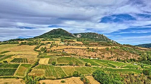
Mont Poupet JGS25 · CC BY 4.0

Climate of Arrondissement of Dole
Best months for sightseeingBest months for sightseeing: May–September.
This month · November
A cold month
Day 9° · Night 3° · Rain 97 mm
- Hottest month
- July (day 25°)
- Coldest month
- January (night 0°)
- Wettest month
- May (102 mm)
- Driest month
- March (67 mm)
Bars: average monthly low and high temperature. Below: precipitation. Monthly averages for 1970–2000 at about 18 km resolution, adjusted for elevation. Highlighted months are mild and relatively dry. Source: WorldClim 2.1 (CC BY 4.0).
Show values as a table
| Month | Jan | Feb | Mar | Apr | May | Jun | Jul | Aug | Sep | Oct | Nov | Dec |
|---|---|---|---|---|---|---|---|---|---|---|---|---|
| Average high (°C) | 5° | 7° | 12° | 15° | 19° | 22° | 25° | 25° | 21° | 16° | 9° | 6° |
| Average low (°C) | 0° | 0° | 3° | 5° | 10° | 13° | 14° | 14° | 11° | 8° | 3° | 1° |
| Precipitation (mm) | 80 | 76 | 67 | 81 | 102 | 90 | 78 | 71 | 93 | 95 | 97 | 88 |
Other places to visit in this season: May June July August September
How to get to Arrondissement of Dole
The nearest airport is Dole Tavaux Airport (DLE), 15 km to the west as the crow flies. For international flights: Geneva International Airport (GVA) (94 km). The nearest large city is Besançon, 41 km to the northeast.
Airports
- Dole Tavaux Airport (DLE) Dole 15 kmwest
- Geneva International Airport (GVA) Geneva 94 kmsoutheast
- Annecy Meythet airport (NCY) Annecy 126 kmsouth
Nearby large cities
- Besançon Population: 128.4K 41 kmnortheast
- Dijon Population: 159.9K 57 kmnorthwest
- Lausanne Population: 139.1K 95 kmsoutheast
- Geneva Population: 201.7K 98 kmsoutheast
- Bern Population: 121.6K 139 kmeast
Straight-line distances; road distances are longer. Airport data: OurAirports.
Day trips from Arrondissement of Dole
Within 100 km: 181 historic and cultural sites, 436 natural sites, 178 lakes, rivers and coasts.
0–25 km34 places
- Étang Seigneur Lake 16 kmSW
- Mont Roland Mountain 16 kmNW
- Bois de Vallun Natural site 14 kmE
- Forêt de Vaivres Natural site 19 kmS
25–60 km202 places
- Lac de Saint-Point Lake 57 kmE
- Lac de Remoray Lake 56 kmSE
- Lac de la Motte Lake 48 kmSE
- Étang Millot Lake 39 kmW
60–100 km559 places
- Lake Neuchâtel Lake 96 kmE
- Lac de Joux Lake 66 kmSE
- Lake Leman Lake 91 kmSE
- Lac Brenet Lake 66 kmSE
Straight-line distances.
Arrondissement of Dole and similar cities
Side by side with cities of similar size in the same country: population, elevation and climate.
| Measure | Arrondissement of Dole | Nancy | Boulogne-Billancourt | Caen |
|---|---|---|---|---|
| Population | 106.1K | 105.1K | 108.8K | 110.6K |
| Elevation | 210 m | 212 m | 35 m | 21 m |
| Summer day (hottest month) | 25° | 24° | 25° | 23° |
| Winter night (coldest month) | 0° | -1° | 2° | 3° |
| Annual rainfall | 1,018 mm | 789 mm | 632 mm | 754 mm |
| Best months | May–Sep | Jun–Sep | May–Sep | Jun–Sep |
| Distance | — | 191 km | 324 km | 506 km |
Climate values are 1970–2000 monthly averages; straight-line distance.
Places in Arrondissement of Dole
189 places- 1 Dole 23.6K
- 2 Poligny 4.1K
- 3 Tavaux 3.9K
- 4 Arbois 3.4K
- 5 Damparis 2.7K
- 6 Salins-les-Bains 2.7K
- 7 Foucherans 2.2K
- 8 Saint-Aubin 1.8K
- 9 Chaussin 1.7K
- 10 Champvans 1.4K
- 11 Dampierre 1.3K
- 12 Mont-sous-Vaudrey 1.3K
- 13 Fraisans 1.2K
- 14 Sampans 1.2K
- 15 Mouchard 1.1K
- 16 Petit-Noir 1.1K
- 17 Orchamps 1.1K
- 18 Choisey 1.1K
- 19 Le Deschaux 1K
- 20 Parcey 961
- 21 Abergement-la-Ronce 845
- 22 Authume 821
- 23 Villette-lès-Dole 769
- 24 Asnans-Beauvoisin 726
- 25 Gevry 685
- 26 Villers-Farlay 669
- 27 Rochefort-sur-Nenon 662
- 28 Brevans 660
- 29 Crissey 640
- 30 Évans 640
- 31 Salans 580
- 32 Mesnay 579
- 33 Jouhe 557
- 34 Moissey 557
- 35 La Loye 549
- 36 Port-Lesney 538
- 37 Rans 538
- 38 Neublans-Abergement 529
- 39 Cramans 524
- 40 Longwy-sur-le-Doubs 513
- 41 Rahon 509
- 42 Molay 502
- 43 Baverans 499
- 44 Ranchot 486
- 45 Champagney 485
- 46 Souvans 483
- 47 Saint-Lothain 473
- 48 Tourmont 471
- 49 Aumont 460
- 50 Champdivers 433
- 51 Gendrey 430
- 52 Grozon 428
- 53 Amange 427
- 54 Aiglepierre 426
- 55 Monnières 425
- 56 Pleure 424
- 57 Chamblay 423
- 58 Étrepigney 423
- 59 La Vieille-Loye 408
- 60 Marnoz 407
Bar: population relative to the most populous place in this list.
Nearby attractions & nature
Everything nearby-
Ruisseau de la Tanche River, Jura4.3 km N
-
Cuisance River, Jura4.9 km W
-
Ruisseau la Larine River, Jura6.4 km E
-
Forêt de Chaux Natural site, Jura9.2 km NE
-
Forêt de Rahon Natural site, Jura10 km W
-
Veuge River, Jura10 km SW
-
Forêt de Gatey Natural site, Jura13 km SW
-
Grozonne River, Jura12 km S
Sources & licences
Data last updated: