Arrondissement of Dole
Located in Jura, Bourgogne-Franche-Comté Coordinates: 47°00′28″ N 5°36′58″ E
- Population
- 106,061
- 106.1K
- Elevation
- 210 m
- above sea level
- Local time
- UTC+01:00
- Europe/Paris · UTC+01:00
- Places inside
- 189
- listed under Arrondissement of Dole
- Airports
- DLE Dole Tavaux Airport15 km
- GVA Geneva International Airport94 km
About Arrondissement of Dole
Arrondissement of Dole is a municipality. Location: Jura, Bourgogne-Franche-Comté. Population: 106,061. Elevation: 210 m. The best months to visit are May–September. The nearest airport is Dole Tavaux Airport (15 km). Nearby sights include Ruisseau de la Tanche and Cuisance.
Photos of Arrondissement of Dole
-
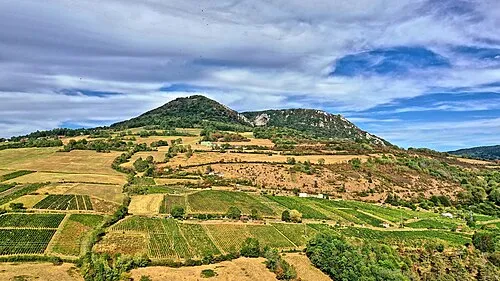
Mont Poupet JGS25 · CC BY 4.0

Climate of Arrondissement of Dole
Best months for sightseeingBest months for sightseeing: May–September.
This month · November
A cold month
Day 9° · Night 3° · Rain 97 mm
- Hottest month
- July (day 25°)
- Coldest month
- January (night 0°)
- Wettest month
- May (102 mm)
- Driest month
- March (67 mm)
Bars: average monthly low and high temperature. Below: precipitation. Monthly averages for 1970–2000 at about 18 km resolution, adjusted for elevation. Highlighted months are mild and relatively dry. Source: WorldClim 2.1 (CC BY 4.0).
Show values as a table
| Month | Jan | Feb | Mar | Apr | May | Jun | Jul | Aug | Sep | Oct | Nov | Dec |
|---|---|---|---|---|---|---|---|---|---|---|---|---|
| Average high (°C) | 5° | 7° | 12° | 15° | 19° | 22° | 25° | 25° | 21° | 16° | 9° | 6° |
| Average low (°C) | 0° | 0° | 3° | 5° | 10° | 13° | 14° | 14° | 11° | 8° | 3° | 1° |
| Precipitation (mm) | 80 | 76 | 67 | 81 | 102 | 90 | 78 | 71 | 93 | 95 | 97 | 88 |
Other places to visit in this season: May June July August September
How to get to Arrondissement of Dole
The nearest airport is Dole Tavaux Airport (DLE), 15 km to the west as the crow flies. For international flights: Geneva International Airport (GVA) (94 km). The nearest large city is Besançon, 41 km to the northeast.
Airports
- Dole Tavaux Airport (DLE) Dole 15 kmwest
- Geneva International Airport (GVA) Geneva 94 kmsoutheast
- Annecy Meythet airport (NCY) Annecy 126 kmsouth
Nearby large cities
- Besançon Population: 128.4K 41 kmnortheast
- Dijon Population: 159.9K 57 kmnorthwest
- Lausanne Population: 139.1K 95 kmsoutheast
- Geneva Population: 201.7K 98 kmsoutheast
- Bern Population: 121.6K 139 kmeast
Straight-line distances; road distances are longer. Airport data: OurAirports.
Day trips from Arrondissement of Dole
Within 100 km: 181 historic and cultural sites, 436 natural sites, 178 lakes, rivers and coasts.
0–25 km34 places
- Étang Seigneur Lake 16 kmSW
- Mont Roland Mountain 16 kmNW
- Bois de Vallun Natural site 14 kmE
- Forêt de Vaivres Natural site 19 kmS
25–60 km202 places
- Lac de Saint-Point Lake 57 kmE
- Lac de Remoray Lake 56 kmSE
- Lac de la Motte Lake 48 kmSE
- Étang Millot Lake 39 kmW
60–100 km559 places
- Lake Neuchâtel Lake 96 kmE
- Lac de Joux Lake 66 kmSE
- Lake Leman Lake 91 kmSE
- Lac Brenet Lake 66 kmSE
Straight-line distances.
Arrondissement of Dole and similar cities
Side by side with cities of similar size in the same country: population, elevation and climate.
| Measure | Arrondissement of Dole | Nancy | Boulogne-Billancourt | Caen |
|---|---|---|---|---|
| Population | 106.1K | 105.1K | 108.8K | 110.6K |
| Elevation | 210 m | 212 m | 35 m | 21 m |
| Summer day (hottest month) | 25° | 24° | 25° | 23° |
| Winter night (coldest month) | 0° | -1° | 2° | 3° |
| Annual rainfall | 1,018 mm | 789 mm | 632 mm | 754 mm |
| Best months | May–Sep | Jun–Sep | May–Sep | Jun–Sep |
| Distance | — | 191 km | 324 km | 506 km |
Climate values are 1970–2000 monthly averages; straight-line distance.
Places in Arrondissement of Dole
189 places- 61 Biarne 406
- 62 Bersaillin 402
- 63 Tassenières 394
- 64 Falletans 391
- 65 Vaudrey 388
- 66 Buvilly 386
- 67 Éclans-Nenon 386
- 68 Thervay 385
- 69 Villette-lès-Arbois 383
- 70 Châtenois 382
- 71 Annoire 379
- 72 Gatey 378
- 73 Ougney 370
- 74 Aumur 367
- 75 Ounans 367
- 76 Montholier 354
- 77 Chemin 343
- 78 Pagney 337
- 79 Dammartin-Marpain 333
- 80 Chissey-sur-Loue 324
- 81 Les Hays 324
- 82 Malange 323
- 83 Lavans-lès-Dole 322
- 84 La Chapelle-sur-Furieuse 318
- 85 Montbarrey 317
- 86 Peseux 316
- 87 Santans 305
- 88 Balaiseaux 303
- 89 Menotey 298
- 90 Vitreux 286
- 91 Saint-Loup 284
- 92 Chevigny 281
- 93 Nevy-lès-Dole 274
- 94 Vadans 274
- 95 Audelange 272
- 96 Bracon 270
- 97 Rainans 270
- 98 Colonne 268
- 99 Belmont 266
- 100 Montigny-lès-Arsures 264
- 101 Saint-Baraing 264
- 102 Les Essards-Taignevaux 262
- 103 Sermange 257
- 104 Courtefontaine 244
- 105 Pupillin 240
- 106 Lemuy 237
- 107 Les Arsures 237
- 108 Pont-d'Héry 236
- 109 Pagnoz 234
- 110 Villers-Robert 231
- 111 Oussières 230
- 112 La Barre 229
- 113 Saint-Cyr-Montmalin 228
- 114 Plasne 224
- 115 Archelange 223
- 116 Écleux 222
- 117 Brans 221
- 118 La Bretenière 220
- 119 Villers-les-Bois 210
- 120 Romain 205
Bar: population relative to the most populous place in this list.
Nearby attractions & nature
Everything nearby-
Ruisseau de la Tanche River, Jura4.3 km N
-
Cuisance River, Jura4.9 km W
-
Ruisseau la Larine River, Jura6.4 km E
-
Forêt de Chaux Natural site, Jura9.2 km NE
-
Forêt de Rahon Natural site, Jura10 km W
-
Veuge River, Jura10 km SW
-
Forêt de Gatey Natural site, Jura13 km SW
-
Grozonne River, Jura12 km S
Sources & licences
Data last updated: