- Population
- 171,651
- 171.7K
- Elevation
- 200 m
- above sea level
- Local time
- UTC+01:00
- Europe/Paris · UTC+01:00
- Places inside
- 109
- listed under Arrondissement of Narbonne
- Airports
- PGF Perpignan-Rivesaltes (Llabanère) Airport38 km
- CCF Carcassonne Salvaza Airport45 km
About Arrondissement of Narbonne
Arrondissement of Narbonne is a municipality. Location: Aude, Occitanie. Population: 171,651. Elevation: 200 m. The best months to visit are May–September. The nearest airport is Perpignan-Rivesaltes (Llabanère) Airport (38 km). Nearby sights include Bois du Vicomte and Bois de Loumet.
Photos of Arrondissement of Narbonne
-
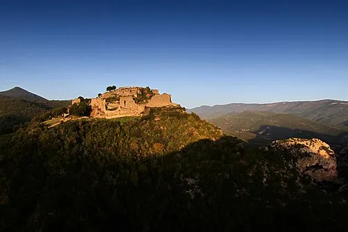
Château de Termes OlivierDeTermes · CC BY-SA 4.0 -
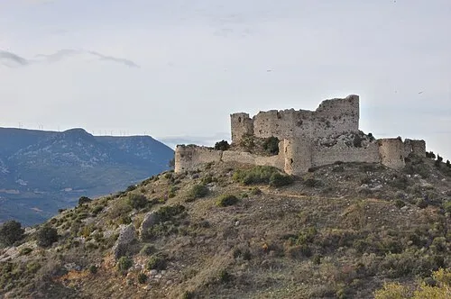
Château d'Aguilar Hien Le · CC BY 2.0


Climate of Arrondissement of Narbonne
Best months for sightseeingBest months for sightseeing: May–September.
This month · November
Outside the best season
Day 13° · Night 6° · Rain 55 mm
- Hottest month
- July (day 27°)
- Coldest month
- January (night 3°)
- Wettest month
- October (79 mm)
- Driest month
- July (19 mm)
Bars: average monthly low and high temperature. Below: precipitation. Monthly averages for 1970–2000 at about 18 km resolution, adjusted for elevation. Highlighted months are mild and relatively dry. Source: WorldClim 2.1 (CC BY 4.0).
Show values as a table
| Month | Jan | Feb | Mar | Apr | May | Jun | Jul | Aug | Sep | Oct | Nov | Dec |
|---|---|---|---|---|---|---|---|---|---|---|---|---|
| Average high (°C) | 10° | 11° | 14° | 16° | 20° | 24° | 27° | 27° | 23° | 18° | 13° | 11° |
| Average low (°C) | 3° | 4° | 5° | 7° | 11° | 15° | 17° | 17° | 14° | 11° | 6° | 4° |
| Precipitation (mm) | 64 | 52 | 50 | 58 | 59 | 40 | 19 | 37 | 51 | 79 | 55 | 70 |
Other places to visit in this season: May June July August September
How to get to Arrondissement of Narbonne
The nearest airport is Perpignan-Rivesaltes (Llabanère) Airport (PGF), 38 km to the south as the crow flies. The nearest large city is Perpignan, 43 km to the south.
Airports
- Perpignan-Rivesaltes (Llabanère) Airport (PGF) Perpignan/Rivesaltes 38 kmsouth
- Carcassonne Salvaza Airport (CCF) Carcassonne 45 kmwest
- Béziers Vias airport (BZR) Béziers 51 kmnortheast
Nearby large cities
- Perpignan Population: 110.7K 43 kmsouth
- Montpellier Population: 248.3K 104 kmnortheast
- Girona Population: 100.3K 122 kmsouth
- Toulouse Population: 511.7K 126 kmnorthwest
- Nîmes Population: 148.2K 150 kmnortheast
Straight-line distances; road distances are longer. Airport data: OurAirports.
Day trips from Arrondissement of Narbonne
Within 100 km: 132 historic and cultural sites, 937 natural sites, 250 lakes, rivers and coasts.
0–25 km95 places
- Plage des Chalets Beach 24 kmE
- Plage de la Vieille Nouvelle Beach 21 kmE
- Île Sainte-Lucie Island 18 kmE
- Île de l'Aute Island 15 kmE
25–60 km261 places
- Torreilles Plage Beach 40 kmSE
- Dosse Petit Island 33 kmSE
- Dosse Gros Island 32 kmSE
- ile des Sidrières Island 25 kmSE
60–100 km963 places
- Platja de Perafita Beach 74 kmS
- Puig Joan Mountain 74 kmS
- Platja de Port-alguer Beach 96 kmSE
- Platja d'Empuriabrava Beach 97 kmS
Straight-line distances.
Arrondissement of Narbonne and similar cities
Side by side with cities of similar size in the same country: population, elevation and climate.
| Measure | Arrondissement of Narbonne | Toulon | Angers | Saint-Etienne |
|---|---|---|---|---|
| Population | 171.7K | 168.7K | 168.3K | 176.3K |
| Elevation | 200 m | 12 m | 42 m | 529 m |
| Summer day (hottest month) | 27° | 28° | 25° | 26° |
| Winter night (coldest month) | 3° | 6° | 2° | 0° |
| Annual rainfall | 634 mm | 675 mm | 726 mm | 912 mm |
| Best months | May–Sep | May–Oct | Jun–Sep | Jun–Sep |
| Distance | — | 253 km | 555 km | 290 km |
Climate values are 1970–2000 monthly averages; straight-line distance.
Places in Arrondissement of Narbonne
109 places- 1 Narbonne 56.7K
- 2 Coursan 21.3K
- 3 Lézignan-Corbières 10.9K
- 4 Port-la-Nouvelle 5.9K
- 5 Sigean 5.7K
- 6 Gruissan 5.1K
- 7 Leucate 4.3K
- 8 Fleury 4.2K
- 9 Cuxac-d'Aude 4.1K
- 10 Salles-d'Aude 3.4K
- 11 Sallèles-d'Aude 3.2K
- 12 Ouveillan 2.7K
- 13 Vinassan 2.7K
- 14 Argeliers 2.1K
- 15 Saint-Nazaire-d'Aude 2.1K
- 16 Moussan 2.1K
- 17 Saint-Marcel-sur-Aude 2K
- 18 Canet 1.9K
- 19 Bizanet 1.7K
- 20 La Palme 1.7K
- 21 Ginestas 1.6K
- 22 Montredon-des-Corbières 1.5K
- 23 Armissan 1.5K
- 24 Saint-André-de-Roquelongue 1.4K
- 25 Bize-Minervois 1.4K
- 26 Portel-des-Corbières 1.3K
- 27 Marcorignan 1.3K
- 28 Fabrezan 1.3K
- 29 Névian 1.3K
- 30 Ferrals-les-Corbières 1.3K
- 31 Luc-sur-Orbieu 1.2K
- 32 Ornaisons 1.2K
- 33 Fitou 1.2K
- 34 Peyriac-de-Mer 1.1K
- 35 Roquefort-des-Corbières 1K
- 36 Conilhac-Corbières 954
- 37 Cruscades 936
- 38 Caves 879
- 39 Tuchan 790
- 40 Bages 750
- 41 Mirepeisset 750
- 42 Boutenac 739
- 43 Saint-Laurent-de-la-Cabrerisse 738
- 44 Moux 719
- 45 Paraza 700
- 46 Durban-Corbières 649
- 47 Montséret 620
- 48 Homps 609
- 49 Mailhac 595
- 50 Fontcouverte 575
- 51 Villedaigne 573
- 52 Lagrasse 548
- 53 Ventenac-en-Minervois 543
- 54 Thézan-des-Corbières 536
- 55 Sainte-Valière 534
- 56 Paziols 528
- 57 Pouzols-Minervois 525
- 58 Roubia 520
- 59 Escales 512
- 60 Castelnau-d'Aude 497
Bar: population relative to the most populous place in this list.
Nearby attractions & nature
Everything nearby-
Bois du Vicomte Natural site, Aude5.2 km E
-
Bois de Loumet Natural site, Aude6.1 km NE
-
Bois de la Pinède Natural site, Aude6.6 km NW
-
Rabet River, Aude9.2 km W
-
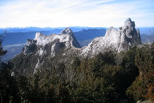 Corbières Mountain, Aude24 km SW
-
Ruisseau du Rémouly River, Aude11 km W
-
Nielle River, Aude11 km NW
-
Aussou River, Aude12 km N
Sources & licences
Data last updated: