- Population
- 171,651
- 171.7K
- Elevation
- 200 m
- above sea level
- Local time
- UTC+01:00
- Europe/Paris · UTC+01:00
- Places inside
- 109
- listed under Arrondissement of Narbonne
- Airports
- PGF Perpignan-Rivesaltes (Llabanère) Airport38 km
- CCF Carcassonne Salvaza Airport45 km
About Arrondissement of Narbonne
Arrondissement of Narbonne is a municipality. Location: Aude, Occitanie. Population: 171,651. Elevation: 200 m. The best months to visit are May–September. The nearest airport is Perpignan-Rivesaltes (Llabanère) Airport (38 km). Nearby sights include Bois du Vicomte and Bois de Loumet.
Photos of Arrondissement of Narbonne
-
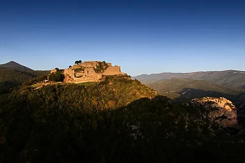
Château de Termes OlivierDeTermes · CC BY-SA 4.0 -
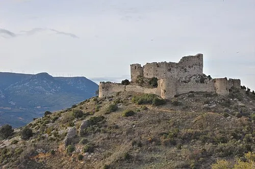
Château d'Aguilar Hien Le · CC BY 2.0


Climate of Arrondissement of Narbonne
Best months for sightseeingBest months for sightseeing: May–September.
This month · November
Outside the best season
Day 13° · Night 6° · Rain 55 mm
- Hottest month
- July (day 27°)
- Coldest month
- January (night 3°)
- Wettest month
- October (79 mm)
- Driest month
- July (19 mm)
Bars: average monthly low and high temperature. Below: precipitation. Monthly averages for 1970–2000 at about 18 km resolution, adjusted for elevation. Highlighted months are mild and relatively dry. Source: WorldClim 2.1 (CC BY 4.0).
Show values as a table
| Month | Jan | Feb | Mar | Apr | May | Jun | Jul | Aug | Sep | Oct | Nov | Dec |
|---|---|---|---|---|---|---|---|---|---|---|---|---|
| Average high (°C) | 10° | 11° | 14° | 16° | 20° | 24° | 27° | 27° | 23° | 18° | 13° | 11° |
| Average low (°C) | 3° | 4° | 5° | 7° | 11° | 15° | 17° | 17° | 14° | 11° | 6° | 4° |
| Precipitation (mm) | 64 | 52 | 50 | 58 | 59 | 40 | 19 | 37 | 51 | 79 | 55 | 70 |
Other places to visit in this season: May June July August September
How to get to Arrondissement of Narbonne
The nearest airport is Perpignan-Rivesaltes (Llabanère) Airport (PGF), 38 km to the south as the crow flies. The nearest large city is Perpignan, 43 km to the south.
Airports
- Perpignan-Rivesaltes (Llabanère) Airport (PGF) Perpignan/Rivesaltes 38 kmsouth
- Carcassonne Salvaza Airport (CCF) Carcassonne 45 kmwest
- Béziers Vias airport (BZR) Béziers 51 kmnortheast
Nearby large cities
- Perpignan Population: 110.7K 43 kmsouth
- Montpellier Population: 248.3K 104 kmnortheast
- Girona Population: 100.3K 122 kmsouth
- Toulouse Population: 511.7K 126 kmnorthwest
- Nîmes Population: 148.2K 150 kmnortheast
Straight-line distances; road distances are longer. Airport data: OurAirports.
Day trips from Arrondissement of Narbonne
Within 100 km: 132 historic and cultural sites, 937 natural sites, 250 lakes, rivers and coasts.
0–25 km95 places
- Plage des Chalets Beach 24 kmE
- Plage de la Vieille Nouvelle Beach 21 kmE
- Île Sainte-Lucie Island 18 kmE
- Île de l'Aute Island 15 kmE
25–60 km261 places
- Torreilles Plage Beach 40 kmSE
- Dosse Petit Island 33 kmSE
- Dosse Gros Island 32 kmSE
- ile des Sidrières Island 25 kmSE
60–100 km963 places
- Platja de Perafita Beach 74 kmS
- Puig Joan Mountain 74 kmS
- Platja de Port-alguer Beach 96 kmSE
- Platja d'Empuriabrava Beach 97 kmS
Straight-line distances.
Arrondissement of Narbonne and similar cities
Side by side with cities of similar size in the same country: population, elevation and climate.
| Measure | Arrondissement of Narbonne | Toulon | Angers | Saint-Etienne |
|---|---|---|---|---|
| Population | 171.7K | 168.7K | 168.3K | 176.3K |
| Elevation | 200 m | 12 m | 42 m | 529 m |
| Summer day (hottest month) | 27° | 28° | 25° | 26° |
| Winter night (coldest month) | 3° | 6° | 2° | 0° |
| Annual rainfall | 634 mm | 675 mm | 726 mm | 912 mm |
| Best months | May–Sep | May–Oct | Jun–Sep | Jun–Sep |
| Distance | — | 253 km | 555 km | 290 km |
Climate values are 1970–2000 monthly averages; straight-line distance.
Places in Arrondissement of Narbonne
109 places- 61 Tourouzelle 493
- 62 Talairan 436
- 63 Camplong-d'Aude 389
- 64 Saint-Couat-d'Aude 387
- 65 Villesèque-des-Corbières 376
- 66 Argens-Minervois 375
- 67 Montbrun-des-Corbières 343
- 68 Tournissan 284
- 69 Saint-Jean-de-Barrou 272
- 70 Treilles 263
- 71 Ribaute 262
- 72 Villeneuve-les-Corbières 253
- 73 Fraissé-des-Corbières 232
- 74 Raissac-d'Aude 222
- 75 Saint-Pierre-des-Champs 213
- 76 Cascastel des Corbieres 212
- 77 Davejean 163
- 78 Embres-et-Castelmaure 152
- 79 Roquecourbe-Minervois 150
- 80 Duilhac-sous-Peyrepertuse 147
- 81 Villerouge-Termenès 143
- 82 Fontjoncouse 139
- 83 Padern 139
- 84 Laroque-de-Fa 138
- 85 Félines-Termenès 130
- 86 Soulatgé 130
- 87 Cucugnan 125
- 88 Coustouge 116
- 89 Mouthoumet 115
- 90 Albières 111
- 91 Feuilla 107
- 92 Vignevieille 106
- 93 Bouisse 104
- 94 Rouffiac-des-Corbières 89
- 95 Albas 78
- 96 Quintillan 62
- 97 Lanet 57
- 98 Lairière 52
- 99 Maisons 52
- 100 Termes 48
- 101 Jonquières 45
- 102 Dernacueillette 44
- 103 Montjoi 40
- 104 Montgaillard 37
- 105 Auriac 33
- 106 Palairac 33
- 107 Massac 30
- 108 Saint-Martin-des-Puits 30
- 109 Salza 18
Bar: population relative to the most populous place in this list.
Nearby attractions & nature
Everything nearby-
Bois du Vicomte Natural site, Aude5.2 km E
-
Bois de Loumet Natural site, Aude6.1 km NE
-
Bois de la Pinède Natural site, Aude6.6 km NW
-
Rabet River, Aude9.2 km W
-
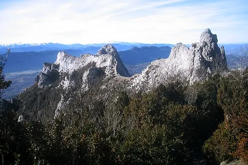 Corbières Mountain, Aude24 km SW
-
Ruisseau du Rémouly River, Aude11 km W
-
Nielle River, Aude11 km NW
-
Aussou River, Aude12 km N
Sources & licences
Data last updated: