- Population
- 111
- 111
- Elevation
- 488 m
- above sea level
- Local time
- UTC+01:00
- Europe/Paris · UTC+01:00
- Places inside
- 2
- listed under Albières
- Airports
- CCF Carcassonne Salvaza Airport33 km
- PGF Perpignan-Rivesaltes (Llabanère) Airport39 km
About Albières
Albières is a village. Location: Arrondissement of Narbonne, Aude. Population: 111. Elevation: 488 m. The best months to visit are June–September. The nearest airport is Carcassonne Salvaza Airport (33 km). Nearby sights include Mont Escoujeat and Plan Dounat.
Climate of Albières
Best months for sightseeingBest months for sightseeing: June–September.
This month · November
Outside the best season
Day 12° · Night 5° · Rain 75 mm
- Hottest month
- July (day 25°)
- Coldest month
- January (night 2°)
- Wettest month
- October (89 mm)
- Driest month
- July (37 mm)
Bars: average monthly low and high temperature. Below: precipitation. Monthly averages for 1970–2000 at about 18 km resolution, adjusted for elevation. Highlighted months are mild and relatively dry. Source: WorldClim 2.1 (CC BY 4.0).
Show values as a table
| Month | Jan | Feb | Mar | Apr | May | Jun | Jul | Aug | Sep | Oct | Nov | Dec |
|---|---|---|---|---|---|---|---|---|---|---|---|---|
| Average high (°C) | 9° | 10° | 12° | 14° | 18° | 22° | 25° | 25° | 22° | 17° | 12° | 10° |
| Average low (°C) | 2° | 2° | 4° | 6° | 10° | 13° | 15° | 16° | 13° | 9° | 5° | 3° |
| Precipitation (mm) | 73 | 65 | 65 | 73 | 86 | 64 | 37 | 57 | 69 | 89 | 75 | 81 |
Other places to visit in this season: June July August September
How to get to Albières
The nearest airport is Carcassonne Salvaza Airport (CCF), 33 km to the northwest as the crow flies. The nearest large city is Perpignan, 44 km to the southeast.
Airports
- Carcassonne Salvaza Airport (CCF) Carcassonne 33 kmnorthwest
- Perpignan-Rivesaltes (Llabanère) Airport (PGF) Perpignan/Rivesaltes 39 kmsoutheast
- Castres Mazamet Airport (DCM) Castres 69 kmnorth
Nearby large cities
- Perpignan Population: 110.7K 44 kmsoutheast
- Girona Population: 100.3K 111 kmsouth
- Toulouse Population: 511.7K 111 kmnorthwest
- Montpellier Population: 248.3K 135 kmnortheast
- Mataró Population: 127K 156 kmsouth
Straight-line distances; road distances are longer. Airport data: OurAirports.
Day trips from Albières
Within 100 km: 146 historic and cultural sites, 1,326 natural sites, 259 lakes, rivers and coasts.
0–25 km131 places
- Roc de Lansac Mountain 22 kmS
- Pla de Saint-Paul Mountain 12 kmSE
- Sarrat Naout Mountain 24 kmSW
- Pech de Fraysse Mountain 16 kmE
25–60 km481 places
- Mediterranean Pyrenees Mountain 53 kmS
- Torreilles Plage Beach 50 kmSE
- Plage des Chalets Beach 55 kmE
- Plage de la Vieille Nouvelle Beach 49 kmE
60–100 km1,119 places
- Platja de Perafita Beach 78 kmSE
- Puig Joan Mountain 77 kmSE
- Platja de Port-alguer Beach 98 kmSE
- Platja d'Empuriabrava Beach 95 kmSE
Straight-line distances.
Places in Albières
2 placesBar: population relative to the most populous place in this list.
Mountains & nature1
- le Pech · Mountain
Nearby attractions & nature
Everything nearby-
Mont Escoujeat Mountain, Auriac3.8 km SE
-
Plan Dounat Mountain, Bouisse4.4 km N
-
Pech de l'Estelhe Mountain, Auriac5 km SE
-
Milobre de Massac Mountain, Auriac5.1 km SE
-
Pic Berlès Mountain, Vignevieille6.3 km NE
-
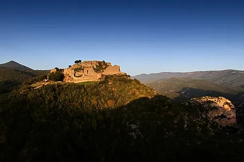 Château de Termes Historic site, Termes8.9 km NE
Sources & licences
Data last updated: