- Population
- 657
- 657
- Elevation
- 69 m
- above sea level
- Local time
- UTC+01:00
- Europe/Paris · UTC+01:00
- Places inside
- 1
- listed under Puilacher
- Airports
- BZR Béziers Vias airport30 km
- MPL Montpellier-Méditerranée Airport37 km
About Puilacher
Puilacher is a village. Location: Arrondissement of Lodève, Hérault. Population: 657. Elevation: 69 m. The best months to visit are May–October. The nearest airport is Béziers Vias airport (30 km). Nearby sights include Ruisseau Dourbie and Lergue.
Climate of Puilacher
Best months for sightseeingBest months for sightseeing: May–October.
This month · November
Outside the best season
Day 14° · Night 7° · Rain 58 mm
- Hottest month
- July (day 29°)
- Coldest month
- January (night 4°)
- Wettest month
- October (92 mm)
- Driest month
- July (20 mm)
Bars: average monthly low and high temperature. Below: precipitation. Monthly averages for 1970–2000 at about 18 km resolution, adjusted for elevation. Highlighted months are mild and relatively dry. Source: WorldClim 2.1 (CC BY 4.0).
Show values as a table
| Month | Jan | Feb | Mar | Apr | May | Jun | Jul | Aug | Sep | Oct | Nov | Dec |
|---|---|---|---|---|---|---|---|---|---|---|---|---|
| Average high (°C) | 11° | 12° | 15° | 17° | 21° | 25° | 29° | 28° | 25° | 20° | 14° | 12° |
| Average low (°C) | 4° | 4° | 6° | 8° | 12° | 16° | 18° | 18° | 15° | 11° | 7° | 5° |
| Precipitation (mm) | 68 | 51 | 47 | 57 | 52 | 36 | 20 | 39 | 58 | 92 | 58 | 66 |
Other places to visit in this season: May June July August September October
How to get to Puilacher
The nearest airport is Béziers Vias airport (BZR), 30 km to the southwest as the crow flies. For international flights: Montpellier-Méditerranée Airport (MPL) (37 km). The nearest large city is Montpellier, 30 km to the east.
Airports
- Béziers Vias airport (BZR) Béziers 30 kmsouthwest
- Montpellier-Méditerranée Airport (MPL) Montpellier/Méditerranée 37 kmeast
- Nîmes-Arles-Camargue Airport (FNI) Nîmes/Garons 76 kmeast
Nearby large cities
- Montpellier Population: 248.3K 30 kmeast
- Nîmes Population: 148.2K 75 kmnortheast
- Perpignan Population: 110.7K 109 kmsouthwest
- Marseille Population: 877.2K 155 kmeast
- Aix-en-Provence Population: 146.8K 157 kmeast
Straight-line distances; road distances are longer. Airport data: OurAirports.
Day trips from Puilacher
Within 100 km: 82 historic and cultural sites, 337 natural sites, 213 lakes, rivers and coasts.
0–25 km47 places
- Plage du Lazaret Beach 24 kmSE
- Plage de la Corniche Beach 23 kmSE
- Plage des Quilles Beach 23 kmSE
- Étang de Thau Lake 22 kmS
25–60 km207 places
- Marseillan Plage Beach 28 kmS
- Plage de l'Espiguette Beach 50 kmE
- Plage du Couchant Beach 46 kmE
- Plage du Grand Travers Beach 44 kmE
60–100 km378 places
- Torreilles Plage Beach 97 kmSW
- Plage de Beauduc Beach 90 kmE
- Plage des Chalets Beach 61 kmSW
- Plage de la Vieille Nouvelle Beach 69 kmSW
Straight-line distances.
Places in Puilacher
1 placeBar: population relative to the most populous place in this list.
Nearby attractions & nature
Everything nearby-
Ruisseau Dourbie River, Hérault2.9 km NW
-
Lergue River, Hérault5.6 km N
-
Montagne de la Moure Mountain, Aumelas11 km E
-
Ruisseau Boyne River, Hérault8.6 km SW
-
Sainte-Marie de Valmagne (Abbey) Historic site, Villeveyrac10 km SE
-
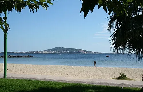 Mont Saint-Clair Mountain, Sète23 km SE
Sources & licences
Data last updated: