- Elevation
- 988 m
- above sea level
- Local time
- UTC+01:00
- Europe/Berlin · UTC+01:00
- Airports
- STR Stuttgart Airport60 km
- FDH Bodensee Airport Friedrichshafen71 km
About Weichenwang
Weichenwang is a mountain. Location: Meßstetten, Zollernalbkreis. Elevation: 988 m.
Weichenwang is a 988.5 m-high (3,243 ft) mountain in the Swabian Jura in the town of Meßstetten, Zollernalbkreis in Baden-Württemberg, Germany. Since 1963 a radome of the Bundeswehr has been there, but its use as a military site is considerably older. Before the radome was built there had been a radio listening-post there.
Source: Wikipedia · CC BY-SA 4.0
At a glance
- Topographic prominence
- 116 m
Source: Wikidata
Photos of Weichenwang
-
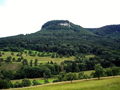
Gräbelesberg Mih · Public domain

Climate of Weichenwang
Best months for sightseeingBest months for sightseeing: June–September.
This month · November
A cold month
Day 4° · Night -3° · Rain 76 mm
- Hottest month
- July (day 20°)
- Coldest month
- January (night -6°)
- Wettest month
- June (111 mm)
- Driest month
- January (63 mm)
Bars: average monthly low and high temperature. Below: precipitation. Monthly averages for 1970–2000 at about 18 km resolution, adjusted for elevation. Highlighted months are mild and relatively dry. Source: WorldClim 2.1 (CC BY 4.0).
Show values as a table
| Month | Jan | Feb | Mar | Apr | May | Jun | Jul | Aug | Sep | Oct | Nov | Dec |
|---|---|---|---|---|---|---|---|---|---|---|---|---|
| Average high (°C) | 0° | 1° | 5° | 9° | 14° | 17° | 20° | 20° | 16° | 10° | 4° | 1° |
| Average low (°C) | -6° | -6° | -3° | -1° | 4° | 7° | 9° | 9° | 6° | 2° | -3° | -5° |
| Precipitation (mm) | 63 | 65 | 63 | 73 | 94 | 111 | 97 | 86 | 66 | 71 | 76 | 77 |
Other places to visit in this season: June July August September
How to get to Weichenwang
The nearest airport is Stuttgart Airport (STR), 60 km to the north as the crow flies. The nearest large city is Reutlingen, 39 km to the northeast.
Airports
- Stuttgart Airport (STR) Stuttgart 60 kmnorth
- Bodensee Airport Friedrichshafen (FDH) Friedrichshafen 71 kmsoutheast
- Zürich Airport (ZRH) Zurich 86 kmsouth
Nearby large cities
- Reutlingen Population: 112.6K 39 kmnortheast
- Stuttgart Population: 612.7K 69 kmnorth
- Winterthur Population: 111.8K 77 kmsouth
- Pforzheim Population: 119.3K 80 kmnorth
- Ulm Population: 120.5K 81 kmeast
Straight-line distances; road distances are longer. Airport data: OurAirports.
Day trips from Weichenwang
Within 100 km: 860 historic and cultural sites, 3,384 natural sites, 934 lakes, rivers and coasts.
0–25 km396 places
- Zundelberg Mountain 21 kmSW
- Zitterboch Mountain 5 kmSE
- Winkel Mountain 5 kmNW
- Wenzelstein Mountain 8 kmNW
25–60 km1,570 places
- Mainau Island 57 kmS
- Strandbad Steckborn Beach 58 kmS
- Insel Werd Island 59 kmS
- Paradiesweiher Lake 59 kmS
60–100 km3,212 places
- Fahr Abbey Attraction 94 kmSW
- Dominikanerinsel Konstanz Island 60 kmS
- Saffa Insel Island 98 kmS
- Pfäffikersee Lake 93 kmS
Straight-line distances.
Nearest towns and villages
-
Meßstetten Town, Meßstetten1.5 km E
-
Hossingen Village, Meßstetten1.9 km W
-
Michelfeld Village, Meßstetten3.2 km W
-
 Unterdigisheim Village, Meßstetten3.5 km SW
-
Hartheim Village, Meßstetten3.4 km S
-
Albstadt Village, Zollernalbkreis6.8 km NE
Nearby attractions & nature
Everything nearby-
Blumersberg Mountain, Meßstetten1.5 km SE
-
Oberer Berg Mountain, Albstadt1.8 km N
-
Gräbelesberg Mountain, Albstadt3.4 km NW
-
Heimberg Mountain, Meßstetten2.9 km SW
-
Heimberg Mountain, Meßstetten2.6 km NW
-
Autenwang Mountain, Albstadt2.7 km NE
-
Kählesbühl Mountain, Meßstetten2.9 km SE
-
Wachtbühl Mountain, Albstadt3.6 km NE
Sources & licences
Data last updated: · 2 independent sources