Berkersheim
Located in Frankfurt, Frankfurt am Main Coordinates: 50°10′00″ N 8°42′00″ E

- Population
- 3,384
- 3.4K
- Elevation
- 156 m
- above sea level
- Local time
- UTC+01:00
- Europe/Berlin · UTC+01:00
- Airports
- FRA Frankfurt Main Airport19 km
- MHG Mannheim-City Airport78 km
About Berkersheim
Berkersheim is a neighbourhood. Location: Frankfurt, Frankfurt am Main. Population: 3,384.
Berkersheim (German pronunciation: [ˈbɛʁkɐshaɪm]) is a quarter of Frankfurt am Main, Germany. It is part of the Ortsbezirk Nord-Ost. Berkersheim had been an independent town until 1910 when it was suburbanised. It is located in the north-eastern part of Frankfurt and borders the districts of Harheim to the north, Frankfurter Berg to the west, Preungesheim and Seckbach to the south and the town of Bad Vilbel to the east.
Source: Wikipedia · CC BY-SA 4.0
At a glance
- Area
- 3.2 km²
Source: Wikidata
Photos of Berkersheim
-

Leonhard Lenz · CC0 -

Karsten Ratzke · CC0 -

Karsten Ratzke · CC0 -

Daviidos · CC BY-SA 3.0 -

Udo Fedderies · CC BY-SA 4.0


Climate of Berkersheim
Best months for sightseeingBest months for sightseeing: May–September.
This month · November
A cold month
Day 7° · Night 2° · Rain 54 mm
- Hottest month
- August (day 24°)
- Coldest month
- February (night -1°)
- Wettest month
- July (69 mm)
- Driest month
- February (43 mm)
Bars: average monthly low and high temperature. Below: precipitation. Monthly averages for 1970–2000 at about 18 km resolution, adjusted for elevation. Highlighted months are mild and relatively dry. Source: WorldClim 2.1 (CC BY 4.0).
Show values as a table
| Month | Jan | Feb | Mar | Apr | May | Jun | Jul | Aug | Sep | Oct | Nov | Dec |
|---|---|---|---|---|---|---|---|---|---|---|---|---|
| Average high (°C) | 4° | 5° | 10° | 14° | 19° | 22° | 24° | 24° | 19° | 13° | 7° | 5° |
| Average low (°C) | -1° | -1° | 2° | 4° | 9° | 12° | 14° | 13° | 10° | 6° | 2° | 0° |
| Precipitation (mm) | 49 | 43 | 46 | 44 | 57 | 66 | 69 | 51 | 53 | 55 | 54 | 61 |
Other places to visit in this season: May June July August September
How to get to Berkersheim
The nearest airport is Frankfurt Main Airport (FRA), 19 km to the southwest as the crow flies. The nearest large city is Frankfurt am Main, 6 km to the south.
Airports
- Frankfurt Main Airport (FRA) Frankfurt am Main 19 kmsouthwest
- Mannheim-City Airport (MHG) Mannheim 78 kmsouth
- Frankfurt-Hahn Airport (HHN) Frankfurt am Main (Lautzenhausen) 106 kmwest
Nearby large cities
- Frankfurt am Main Population: 650K 6 kmsouth
- Offenbach Population: 119.2K 9 kmsoutheast
- Darmstadt Population: 167K 33 kmsouth
- Wiesbaden Population: 288.8K 34 kmwest
- Mainz Population: 222.9K 36 kmsouthwest
Straight-line distances; road distances are longer. Airport data: OurAirports.
Day trips from Berkersheim
Within 100 km: 969 historic and cultural sites, 4,365 natural sites, 772 lakes, rivers and coasts.
0–25 km355 places
- Hattsteinweiher Lake 24 kmNW
- Ernst-Ludwigs-Teich Lake 24 kmS
- Egelswoog Lake 22 kmS
- Zeilsberg Mountain 17 kmSW
25–60 km1,699 places
- Modau River 43 kmSW
- Lumda River 53 kmN
- Aar River 54 kmNW
- Rüdesheimer Aue Island 59 kmW
60–100 km4,052 places
- Elsenz River 86 kmS
- Weibe River 99 kmNW
- Ohe River 69 kmN
- Felda River 64 kmNE
Straight-line distances.
Nearby attractions & nature
Everything nearby-
Berger Warte Mountain, Frankfurt2.9 km E
-
Lohrberg Natural site, Frankfurt2.7 km SE
-
Huthpark Natural site, Frankfurt2.8 km S
-
Erlenbach River, Hesse2 km NE
-
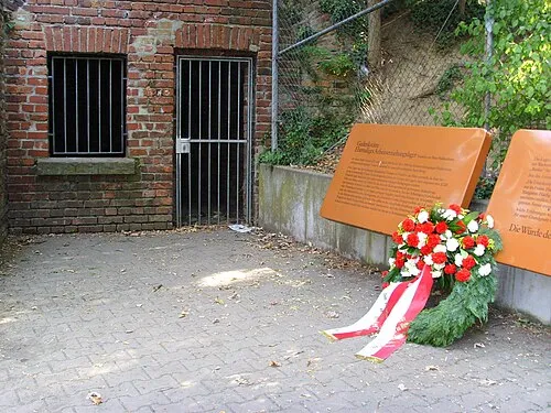 Frankfurt-Heddernheim Concentration Camp Historic site, Frankfurt4.3 km W
-
Europaturm Landmark, Frankfurt4.8 km SW
Other cities and towns in Frankfurt
-
 Nieder-Eschbach Neighbourhood, Frankfurt4.4 km NW
-
 Bockenheim Neighbourhood, Frankfurt6.1 km SW
-
Niederursel Neighbourhood, Frankfurt5.8 km W
-
 Altstadt Neighbourhood, Frankfurt6.4 km S
-
 Bahnhofsviertel Neighbourhood, Frankfurt7 km S
-
 Harheim Neighbourhood, Frankfurt2 km N
Sources & licences
Data last updated: · 2 independent sources