Angelhofer Altrhein
Located in Rhineland-Palatinate, Germany Coordinates: 49°22′00″ N 8°29′00″ E
- Elevation
- 99 m
- above sea level
- Local time
- UTC+01:00
- Europe/Berlin · UTC+01:00
- Airports
- MHG Mannheim-City Airport12 km
- FKB Karlsruhe Baden-Baden Airport72 km
About Angelhofer Altrhein
Angelhofer Altrhein is a lake. Location: Rhineland-Palatinate, Germany. Elevation: 99 m. The best months to visit are May–September. The nearest airport is Mannheim-City Airport (12 km). Nearby sights include Böllenwörth and Angelwald.
Climate of Angelhofer Altrhein
Best months for sightseeingBest months for sightseeing: May–September.
This month · November
A cold month
Day 8° · Night 3° · Rain 56 mm
- Hottest month
- July (day 25°)
- Coldest month
- January (night -1°)
- Wettest month
- July (78 mm)
- Driest month
- January (42 mm)
Bars: average monthly low and high temperature. Below: precipitation. Monthly averages for 1970–2000 at about 18 km resolution, adjusted for elevation. Highlighted months are mild and relatively dry. Source: WorldClim 2.1 (CC BY 4.0).
Show values as a table
| Month | Jan | Feb | Mar | Apr | May | Jun | Jul | Aug | Sep | Oct | Nov | Dec |
|---|---|---|---|---|---|---|---|---|---|---|---|---|
| Average high (°C) | 4° | 6° | 11° | 15° | 20° | 23° | 25° | 25° | 21° | 14° | 8° | 5° |
| Average low (°C) | -1° | -1° | 2° | 5° | 9° | 12° | 14° | 14° | 10° | 6° | 3° | 0° |
| Precipitation (mm) | 42 | 42 | 46 | 47 | 73 | 71 | 78 | 48 | 55 | 55 | 56 | 56 |
Other places to visit in this season: May June July August September
How to get to Angelhofer Altrhein
The nearest airport is Mannheim-City Airport (MHG), 12 km to the north as the crow flies. For international flights: Karlsruhe Baden-Baden Airport (FKB) (72 km). The nearest large city is Ludwigshafen am Rhein, 13 km to the north.
Airports
- Mannheim-City Airport (MHG) Mannheim 12 kmnorth
- Karlsruhe Baden-Baden Airport (FKB) Rheinmünster 72 kmsouthwest
- Frankfurt Main Airport (FRA) Frankfurt am Main 74 kmnorth
Nearby large cities
- Ludwigshafen am Rhein Population: 163.2K 13 kmnorth
- Mannheim Population: 308K 14 kmnorth
- Heidelberg Population: 143.3K 16 kmeast
- Karlsruhe Population: 283.8K 40 kmsouth
- Pforzheim Population: 119.3K 56 kmsouth
Straight-line distances; road distances are longer. Airport data: OurAirports.
Day trips from Angelhofer Altrhein
Within 100 km: 1,100 historic and cultural sites, 3,918 natural sites, 856 lakes, rivers and coasts.
0–25 km381 places
- Elsenz River 23 kmE
- Friesenheimer Insel Island 17 kmN
- Insel Flotzgrün Island 10 kmS
- Neckarinsel Island 15 kmE
25–60 km1,849 places
- Modau River 50 kmN
- Große Woog Lake 57 kmN
- Gelterswoog Lake 57 kmW
- Altrhein Kleiner Bodensee Lake 35 kmS
60–100 km3,644 places
- Hessental Concentration Camp Historic site 98 kmE
- Umpfer River 92 kmE
- Rench River 85 kmSW
- Rüdesheimer Aue Island 78 kmNW
Straight-line distances.
Nearest towns and villages
-
Otterstadt Village, Rhein-Pfalz-Kreis2.7 km W
-
Ketsch Village, Rhein-Neckar-Kreis3.5 km E
-
Otterstadt Village, Otterstadt2.7 km W
-
Kreisfreie Stadt Speyer Municipality, Rhineland-Palatinate6.2 km SW
-
Waldsee Village, Rhein-Pfalz-Kreis4.5 km NW
-
Speyer Village, Kreisfreie Stadt Speyer6.3 km SW
Nearby attractions & nature
Everything nearby-
Böllenwörth Natural site, Rhineland-Palatinate1.9 km N
-
Angelwald Natural site, Rhineland-Palatinate1.9 km S
-
Rheinwald Natural site, Baden-Wurttemberg3 km NE
-
Alter Kraichbach River, Baden-Wurttemberg1.9 km S
-
Otterstadter Altrhein Lake, Rhineland-Palatinate3.2 km N
-
Altrhein Lake, Baden-Wurttemberg3.2 km E
-
Kraichbach River, Baden-Wurttemberg2.4 km E
-
Ketscher Wald Natural site, Baden-Wurttemberg5.2 km E
More lakes, rivers and coasts in Germany
-
Insel Horn Island, Rhineland-Palatinate9.3 km S
-
Altrhein Lake, Rhineland-Palatinate7.5 km N
-
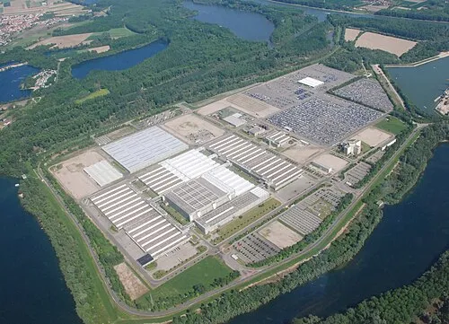 Insel Grün Island, Rhineland-Palatinate15 km SW
-
Silbersee Lake, Rhineland-Palatinate8.1 km N
-
Altrhein Lake, Rhineland-Palatinate9.4 km S
-
Insel Flotzgrün Island, Rhineland-Palatinate9.9 km S
Sources & licences
Data last updated: