Eifelkreis Bitburg-Prüm
Located in Rhineland-Palatinate, Germany Coordinates: 50°04′33″ N 6°22′48″ E
- Population
- 99,788
- 99.8K
- Elevation
- 340 m
- above sea level
- Local time
- UTC+01:00
- Europe/Berlin · UTC+01:00
- Places inside
- 234
- listed under Eifelkreis Bitburg-Prüm
- Airports
- LUX Luxembourg-Findel International Airport51 km
- HHN Frankfurt-Hahn Airport65 km
About Eifelkreis Bitburg-Prüm
Eifelkreis Bitburg-Prüm is a municipality. Location: Rhineland-Palatinate, Germany. Population: 99,788. Elevation: 340 m. The best months to visit are June–August. The nearest airport is Luxembourg-Findel International Airport (51 km). Nearby sights include Dierbach and Bohnenbach.
Photos of Eifelkreis Bitburg-Prüm
-
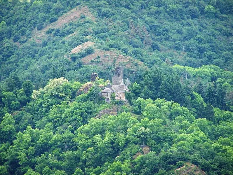
Schloß Falkenstein Brbbl · CC BY-SA 3.0

Climate of Eifelkreis Bitburg-Prüm
Best months for sightseeingBest months for sightseeing: June–August.
This month · November
A cold month
Day 7° · Night 2° · Rain 89 mm
- Hottest month
- August (day 22°)
- Coldest month
- February (night -1°)
- Wettest month
- December (97 mm)
- Driest month
- April (63 mm)
Bars: average monthly low and high temperature. Below: precipitation. Monthly averages for 1970–2000 at about 18 km resolution, adjusted for elevation. Highlighted months are mild and relatively dry. Source: WorldClim 2.1 (CC BY 4.0).
Show values as a table
| Month | Jan | Feb | Mar | Apr | May | Jun | Jul | Aug | Sep | Oct | Nov | Dec |
|---|---|---|---|---|---|---|---|---|---|---|---|---|
| Average high (°C) | 4° | 5° | 9° | 12° | 17° | 20° | 22° | 22° | 18° | 13° | 7° | 4° |
| Average low (°C) | -1° | -1° | 1° | 3° | 8° | 10° | 12° | 12° | 9° | 6° | 2° | 0° |
| Precipitation (mm) | 88 | 69 | 80 | 63 | 73 | 77 | 78 | 64 | 79 | 81 | 89 | 97 |
How to get to Eifelkreis Bitburg-Prüm
The nearest airport is Luxembourg-Findel International Airport (LUX), 51 km to the south as the crow flies. The nearest large city is Trier, 40 km to the southeast.
Airports
- Luxembourg-Findel International Airport (LUX) Luxembourg 51 kmsouth
- Frankfurt-Hahn Airport (HHN) Frankfurt am Main (Lautzenhausen) 65 kmeast
- Liège Airport (LGG) Grâce-Hollogne 91 kmnorthwest
Nearby large cities
- Trier Population: 100.1K 40 kmsoutheast
- Aachen Population: 265.2K 81 kmnorth
- Liège Population: 195.3K 85 kmnorthwest
- Bonn Population: 330.6K 89 kmnortheast
- Koblenz Population: 107.3K 91 kmeast
Straight-line distances; road distances are longer. Airport data: OurAirports.
Day trips from Eifelkreis Bitburg-Prüm
Within 100 km: 419 historic and cultural sites, 2,857 natural sites, 783 lakes, rivers and coasts.
0–25 km344 places
- Steinkopf Mountain 20 kmNW
- Reinersberg Mountain 24 kmNW
- Preis Berg Mountain 21 kmNW
- Schwirzbierg Mountain 23 kmW
25–60 km1,142 places
- Lac de Nisramont Lake 52 kmW
- Lac de Robertville Lake 45 kmNW
- Mont de la Tour de Coo Mountain 51 kmNW
- Steiner Berg Mountain 31 kmNW
60–100 km2,573 places
- Île du Moulin Island 78 kmNW
- Île Monsin Island 84 kmNW
- Île de Franche Garenne Island 85 kmNW
- Lac de la Gileppe Lake 63 kmNW
Straight-line distances.
Eifelkreis Bitburg-Prüm and similar cities
Side by side with cities of similar size in the same country: population, elevation and climate.
| Measure | Eifelkreis Bitburg-Prüm | Trier | Erlangen | Schwerin |
|---|---|---|---|---|
| Population | 99.8K | 100.1K | 102.7K | 96.6K |
| Elevation | 340 m | 141 m | 290 m | 48 m |
| Summer day (hottest month) | 22° | 24° | 24° | 23° |
| Winter night (coldest month) | -1° | 0° | -3° | -2° |
| Annual rainfall | 938 mm | 817 mm | 745 mm | 628 mm |
| Best months | Jun–Aug | Jun–Sep | May–Sep | Jun–Aug |
| Distance | — | 40 km | 337 km | 526 km |
Climate values are 1970–2000 monthly averages; straight-line distance.
Places in Eifelkreis Bitburg-Prüm
234 places- 181 Emmelbaum 81
- 182 Ließem 78
- 183 Oberstedem 72
- 184 Oberlauch 72
- 185 Kesfeld 71
- 186 Harspelt 69
- 187 Niehl 68
- 188 Kaschenbach 67
- 189 Berscheid 62
- 190 Sevenig (Our) 62
- 191 Zweifelscheid 59
- 192 Reiff 58
- 193 Masthorn 56
- 194 Hütten 56
- 195 Übereisenbach 55
- 196 Winringen 53
- 197 Uppershausen 53
- 198 Usch 52
- 199 Manderscheid 52
- 200 Niedergeckler 51
- 201 Niederraden 48
- 202 Nasingen 48
- 203 Mauel 48
- 204 Fischbach-Oberraden 47
- 205 Kinzenburg 47
- 206 Roscheid 47
- 207 Eilscheid 46
- 208 Matzerath 45
- 209 Birtlingen 44
- 210 Kickeshausen 43
- 211 Leimbach 42
- 212 Muxerath 39
- 213 Sevenig bei Neuerburg 38
- 214 Gemünd 38
- 215 Pintesfeld 36
- 216 Herzfeld 35
- 217 Merlscheid 35
- 218 Niederpierscheid 33
- 219 Scheuern 32
- 220 Wettlingen 31
- 221 Niederlauch 31
- 222 Enzen 30
- 223 Affler 30
- 224 Feilsdorf 30
- 225 Scheitenkorb 29
- 226 Strickscheid 28
- 227 Sengerich 26
- 228 Herbstmühle 25
- 229 Etteldorf 22
- 230 Ammeldingen an der Our 20
- 231 Waldhof-Falkenstein 19
- 232 Burg 18
- 233 Keppeshausen 17
- 234 Hamm 16
Bar: population relative to the most populous place in this list.
Nearby attractions & nature
Everything nearby-
Dierbach River, Rhineland-Palatinate0.6 km E
-
Bohnenbach River, Rhineland-Palatinate0.9 km NW
-
Weiherbach River, Rhineland-Palatinate2.2 km NW
-
Geweber Wald Natural site, Rhineland-Palatinate2.9 km E
-
Wald Scheid Natural site, Rhineland-Palatinate5.4 km SE
-
Kleiner Ehlenzbach River, Rhineland-Palatinate5 km E
-
Hardt Wald Natural site, Rhineland-Palatinate5.8 km E
-
Die Hecke Natural site, Rhineland-Palatinate6.1 km NE
Sources & licences
Data last updated: