Köngernheim
Located in Landkreis Mainz-Bingen, Rhineland-Palatinate Coordinates: 49°50′45″ N 8°14′48″ E
- Population
- 1,272
- 1.3K
- Elevation
- 132 m
- above sea level
- Local time
- UTC+01:00
- Europe/Berlin · UTC+01:00
- Places inside
- 1
- listed under Köngernheim
- Airports
- FRA Frankfurt Main Airport30 km
- MHG Mannheim-City Airport46 km
About Köngernheim
Köngernheim is a village. Location: Landkreis Mainz-Bingen, Rhineland-Palatinate. Population: 1,272. Elevation: 132 m. The best months to visit are May–September. The nearest airport is Frankfurt Main Airport (30 km). Nearby sights include Goldbach and Selzer Berg.
Photos of Köngernheim
-
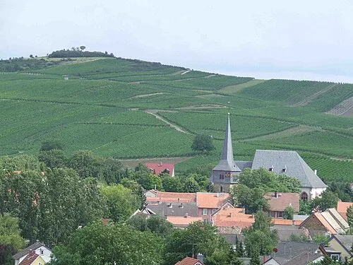
Petersberg User:Kandschwar · CC BY-SA 3.0

Climate of Köngernheim
Best months for sightseeingBest months for sightseeing: May–September.
This month · November
A cold month
Day 8° · Night 2° · Rain 48 mm
- Hottest month
- July (day 25°)
- Coldest month
- January (night -1°)
- Wettest month
- July (66 mm)
- Driest month
- February (37 mm)
Bars: average monthly low and high temperature. Below: precipitation. Monthly averages for 1970–2000 at about 18 km resolution, adjusted for elevation. Highlighted months are mild and relatively dry. Source: WorldClim 2.1 (CC BY 4.0).
Show values as a table
| Month | Jan | Feb | Mar | Apr | May | Jun | Jul | Aug | Sep | Oct | Nov | Dec |
|---|---|---|---|---|---|---|---|---|---|---|---|---|
| Average high (°C) | 4° | 6° | 11° | 15° | 20° | 23° | 25° | 25° | 20° | 14° | 8° | 5° |
| Average low (°C) | -1° | -1° | 2° | 4° | 9° | 12° | 14° | 13° | 10° | 6° | 2° | 1° |
| Precipitation (mm) | 40 | 37 | 42 | 41 | 60 | 59 | 66 | 45 | 47 | 51 | 48 | 51 |
Other places to visit in this season: May June July August September
How to get to Köngernheim
The nearest airport is Frankfurt Main Airport (FRA), 30 km to the northeast as the crow flies. The nearest large city is Mainz, 15 km to the north.
Airports
- Frankfurt Main Airport (FRA) Frankfurt am Main 30 kmnortheast
- Mannheim-City Airport (MHG) Mannheim 46 kmsoutheast
- Frankfurt-Hahn Airport (HHN) Frankfurt am Main (Lautzenhausen) 72 kmwest
Nearby large cities
- Mainz Population: 222.9K 15 kmnorth
- Wiesbaden Population: 288.8K 27 kmnorth
- Darmstadt Population: 167K 29 kmeast
- Mannheim Population: 308K 43 kmsouth
- Ludwigshafen am Rhein Population: 163.2K 43 kmsouth
Straight-line distances; road distances are longer. Airport data: OurAirports.
Day trips from Köngernheim
Within 100 km: 980 historic and cultural sites, 4,089 natural sites, 843 lakes, rivers and coasts.
0–25 km231 places
- Modau River 16 kmE
- Petersaue Island 20 kmN
- Mariannenaue Island 22 kmNW
- Königsklinger Aue Island 21 kmNW
25–60 km1,863 places
- Rüdesheimer Aue Island 27 kmNW
- Friesenheimer Insel Island 39 kmS
- Neckarinsel Island 58 kmSE
- Otterstadter Altrhein Lake 53 kmS
60–100 km3,818 places
- Elsenz River 64 kmSE
- Lumda River 94 kmN
- Aar River 61 kmN
- Urbach River 91 kmNW
Straight-line distances.
Places in Köngernheim
1 placeBar: population relative to the most populous place in this list.
Nearby attractions & nature
Everything nearby-
Goldbach River, Rhineland-Palatinate0.2 km SW
-
Selzer Berg Mountain, Zornheim4 km N
-
Moosberg Mountain, Zornheim4.1 km NW
-
Schanzenhügel Mountain, Weinolsheim3.5 km SE
-
Undenheimer Berg Mountain, Schornsheim4.5 km W
-
Petersberg Mountain, Gau-Odernheim6.5 km SW
Sources & licences
Data last updated: