- Population
- 1,804
- 1.8K
- Elevation
- 762 m
- above sea level
- Local time
- UTC+02:00
- Europe/Athens · UTC+02:00
- Airports
- VOL Nea Anchialos National Airport96 km
- JSI Skiathos Island National Airport111 km
About Kyriáki
Kyriáki is a village. Location: Livadeia, Nomós Voiotías. Population: 1,804. Elevation: 762 m. The best months to visit are May–June, August–September. The nearest airport is Nea Anchialos National Airport (96 km). Nearby sights include Hosios Loukas and Medieval Castle of Livadia.
Photos of Kyriáki
-

Hosios Loukas Berthold Werner · CC BY-SA 3.0

Climate of Kyriáki
Best months for sightseeingBest months for sightseeing: May–June, August–September.
This month · November
Outside the best season
Day 13° · Night 5° · Rain 88 mm
- Hottest month
- July (day 29°)
- Coldest month
- January (night 1°)
- Wettest month
- December (105 mm)
- Driest month
- July (15 mm)
Bars: average monthly low and high temperature. Below: precipitation. Monthly averages for 1970–2000 at about 18 km resolution, adjusted for elevation. Highlighted months are mild and relatively dry. Source: WorldClim 2.1 (CC BY 4.0).
Show values as a table
| Month | Jan | Feb | Mar | Apr | May | Jun | Jul | Aug | Sep | Oct | Nov | Dec |
|---|---|---|---|---|---|---|---|---|---|---|---|---|
| Average high (°C) | 8° | 8° | 11° | 15° | 21° | 26° | 29° | 28° | 24° | 19° | 13° | 9° |
| Average low (°C) | 1° | 1° | 2° | 5° | 10° | 14° | 16° | 16° | 12° | 9° | 5° | 2° |
| Precipitation (mm) | 82 | 80 | 72 | 52 | 36 | 22 | 15 | 18 | 28 | 73 | 88 | 105 |
Other places to visit in this season: May June August September
How to get to Kyriáki
The nearest airport is Nea Anchialos National Airport (VOL), 96 km to the north as the crow flies. For international flights: Athens Eleftherios Venizelos International Airport (ATH) (111 km). The nearest large city is Piraeus, 88 km to the southeast.
Airports
- Nea Anchialos National Airport (VOL) Nea Anchialos 96 kmnorth
- Skiathos Island National Airport (JSI) Skiathos 111 kmnortheast
- Athens Eleftherios Venizelos International Airport (ATH) Spata-Artemida 111 kmsoutheast
Nearby large cities
- Piraeus Population: 163.7K 88 kmsoutheast
- Athens Population: 664K 92 kmsoutheast
- Çanakkale Population: 143.6K 371 kmnortheast
- Çiğli Population: 214.1K 374 kmeast
- Konak Population: 332.3K 377 kmeast
Straight-line distances; road distances are longer. Airport data: OurAirports.
Day trips from Kyriáki
Within 100 km: 30 historic and cultural sites, 5 natural sites, 17 lakes, rivers and coasts.
0–25 km2 places
- Hosios Loukas Attraction 6 kmNW
- Medieval Castle of Livadia Historic site 11 kmNE
25–60 km11 places
- Moní Agíou Ierothéou Attraction 57 kmSE
- Ierá Moní Odigítrias Attraction 26 kmN
- Moní Genesíou Theotókou Damástas Attraction 54 kmNW
- Makronísi Island 27 kmSE
60–100 km39 places
- Agistri Island 88 kmSE
- Pnyx Mountain 92 kmSE
- Moni Osiou David Attraction 70 kmNE
- Moní Antinítsis Attraction 79 kmNW
Straight-line distances.
Nearby attractions & nature
Everything nearby-
Hosios Loukas Attraction, Distomo-Arachova-Antikyra5.9 km NW
-
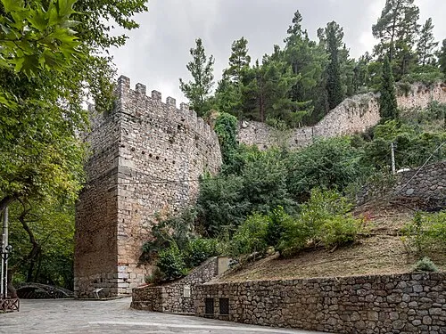 Medieval Castle of Livadia Historic site, Livadeia11 km NE
Sources & licences
Data last updated: