- Population
- 186
- 186
- Elevation
- 143 m
- above sea level
- Local time
- UTC+02:00
- Europe/Athens · UTC+02:00
- Airports
- VOL Nea Anchialos National Airport73 km
- JSI Skiathos Island National Airport94 km
About Parórion
Parórion is a village. Location: Livadeia, Nomós Voiotías. Population: 186. Elevation: 143 m. The best months to visit are April–May, September–October. The nearest airport is Nea Anchialos National Airport (73 km). Nearby sights include Ierá Moní Odigítrias and Hosios Loukas.
Photos of Parórion
-
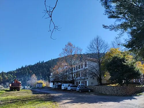
Ierá Moní Odigítrias Pavlos1988 · CC BY-SA 4.0

Climate of Parórion
Best months for sightseeingBest months for sightseeing: April–May, September–October.
This month · November
Outside the best season
Day 17° · Night 8° · Rain 83 mm
- Hottest month
- July (day 32°)
- Coldest month
- January (night 4°)
- Wettest month
- December (98 mm)
- Driest month
- July (13 mm)
Bars: average monthly low and high temperature. Below: precipitation. Monthly averages for 1970–2000 at about 18 km resolution, adjusted for elevation. Highlighted months are mild and relatively dry. Source: WorldClim 2.1 (CC BY 4.0).
Show values as a table
| Month | Jan | Feb | Mar | Apr | May | Jun | Jul | Aug | Sep | Oct | Nov | Dec |
|---|---|---|---|---|---|---|---|---|---|---|---|---|
| Average high (°C) | 11° | 12° | 15° | 20° | 25° | 30° | 32° | 32° | 28° | 23° | 17° | 13° |
| Average low (°C) | 4° | 4° | 6° | 9° | 13° | 17° | 19° | 19° | 16° | 12° | 8° | 5° |
| Precipitation (mm) | 74 | 73 | 67 | 47 | 35 | 22 | 13 | 17 | 29 | 74 | 83 | 98 |
Other places to visit in this season: April May September October
How to get to Parórion
The nearest airport is Nea Anchialos National Airport (VOL), 73 km to the north as the crow flies. The nearest large city is Piraeus, 104 km to the southeast.
Airports
- Nea Anchialos National Airport (VOL) Nea Anchialos 73 kmnorth
- Skiathos Island National Airport (JSI) Skiathos 94 kmnortheast
- Patras Araxos Agamemnon Airport (GPA) Patras 125 kmwest
Nearby large cities
- Piraeus Population: 163.7K 104 kmsoutheast
- Athens Population: 664K 107 kmsoutheast
- Çanakkale Population: 143.6K 361 kmnortheast
- Çiğli Population: 214.1K 376 kmeast
- Konak Population: 332.3K 380 kmeast
Straight-line distances; road distances are longer. Airport data: OurAirports.
Day trips from Parórion
Within 100 km: 17 historic and cultural sites, 3 natural sites, 16 lakes, rivers and coasts.
0–25 km3 places
- Ierá Moní Odigítrias Attraction 7 kmW
- Hosios Loukas Attraction 19 kmS
- Medieval Castle of Livadia Historic site 18 kmSE
25–60 km7 places
- Moní Genesíou Theotókou Damástas Attraction 34 kmNW
- Moni Osiou David Attraction 56 kmNE
- Moní Antinítsis Attraction 57 kmNW
- Makronísi Island 48 kmSE
60–100 km26 places
- Moní Agíou Ierothéou Attraction 76 kmSE
- Paximada Island 97 kmNE
- Panagia Eleousa Attraction 65 kmNW
- Mylopotamos Beach Beach 98 kmNE
Straight-line distances.
Nearby attractions & nature
Everything nearby-
Ierá Moní Odigítrias Attraction, Amfikleia-Elateia7.1 km W
-
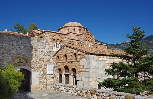 Hosios Loukas Attraction, Distomo-Arachova-Antikyra19 km S
-
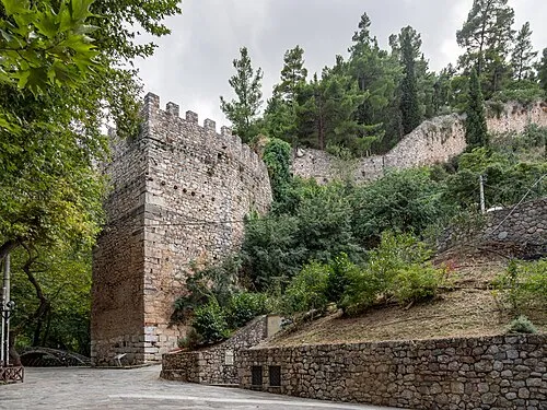 Medieval Castle of Livadia Historic site, Livadeia18 km SE
Sources & licences
Data last updated: