Ano Amygdaloi
Local name: Άνω Αμυγδάλοι
Located in Agios Nikolaos, Lasithi Coordinates: 35°12′37″ N 25°35′41″ E
- Population
- 25
- 25
- Elevation
- 604 m
- above sea level
- Local time
- UTC+02:00
- Europe/Athens · UTC+02:00
- Airports
- HER Heraklion International Nikos Kazantzakis Airport40 km
- JSH Sitia Airport46 km
About Ano Amygdaloi
Ano Amygdaloi is a village. Location: Agios Nikolaos, Lasithi. Population: 25. Elevation: 604 m. The best months to visit are May–October. The nearest airport is Heraklion International Nikos Kazantzakis Airport (40 km). Nearby sights include Spinalonga and Voliares.
Population of Ano Amygdaloi over time
| 1991 | 49 | |
|---|---|---|
| 2001 | 40 | |
| 2011 | 25 | |
| 2021 | 11 |
Censuses and official estimates; source: Wikidata.
Climate of Ano Amygdaloi
Best months for sightseeingBest months for sightseeing: May–October.
This month · November
Outside the best season
Day 16° · Night 10° · Rain 83 mm
- Hottest month
- July (day 27°)
- Coldest month
- February (night 6°)
- Wettest month
- January (148 mm)
- Driest month
- August (2 mm)
Bars: average monthly low and high temperature. Below: precipitation. Monthly averages for 1970–2000 at about 18 km resolution, adjusted for elevation. Highlighted months are mild and relatively dry. Source: WorldClim 2.1 (CC BY 4.0).
Show values as a table
| Month | Jan | Feb | Mar | Apr | May | Jun | Jul | Aug | Sep | Oct | Nov | Dec |
|---|---|---|---|---|---|---|---|---|---|---|---|---|
| Average high (°C) | 12° | 12° | 13° | 17° | 21° | 25° | 27° | 27° | 25° | 21° | 16° | 13° |
| Average low (°C) | 6° | 6° | 7° | 10° | 13° | 17° | 20° | 20° | 17° | 14° | 10° | 8° |
| Precipitation (mm) | 148 | 112 | 88 | 42 | 21 | 7 | 3 | 2 | 20 | 76 | 83 | 131 |
Other places to visit in this season: May June July August September October
How to get to Ano Amygdaloi
The nearest airport is Heraklion International Nikos Kazantzakis Airport (HER), 40 km to the west as the crow flies. The nearest large city is Piraeus, 350 km to the northwest.
Airports
- Heraklion International Nikos Kazantzakis Airport (HER) Heraklion 40 kmwest
- Sitia Airport (JSH) Crete Island 46 kmeast
- Santorini International Airport (JTR) Santorini Island 132 kmnorth
Nearby large cities
- Piraeus Population: 163.7K 350 kmnorthwest
- Athens Population: 664K 350 kmnorthwest
- Aydin Population: 163K 355 kmnortheast
- Karabağlar Population: 479.3K 378 kmnorth
- Konak Population: 332.3K 379 kmnorth
Straight-line distances; road distances are longer. Airport data: OurAirports.
Day trips from Ano Amygdaloi
Within 100 km: 5 historic and cultural sites, 14 natural sites, 10 lakes, rivers and coasts.
0–25 km4 places
- Kolympoi Mountain 24 kmSW
- Voliares Mountain 23 kmS
- Alonakia Mountain 24 kmSW
- Spinalonga Island 16 kmNE
25–60 km18 places
- Halepa Mountain 47 kmW
- Treis Ekklhsies Natural site 52 kmW
- Sklavokampos Natural site 59 kmW
- Kokkini Nirou Historic site 34 kmNW
60–100 km7 places
- Arkadi Monastery Attraction 89 kmW
- Moni Ayiou Panteleimon Attraction 60 kmW
- Vouloumenou Mountain 73 kmW
- Nida Plateau Natural site 69 kmW
Straight-line distances.
Nearby attractions & nature
Everything nearby-
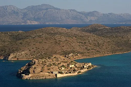 Spinalonga Island, Lasithi16 km NE
-
Voliares Mountain, Viannos23 km S
-
Alonakia Mountain, Viannos24 km SW
-
Kolympoi Mountain, Viannos24 km SW
Sources & licences
Data last updated: · 2 independent sources