- Population
- 518
- 518
- Elevation
- 434 m
- above sea level
- Local time
- UTC+01:00
- Europe/Rome · UTC+01:00
- Airports
- TSF Treviso Airport65 km
- BZO Bolzano Airport78 km
About Fortogna
Fortogna is a village. Location: Longarone, Province of Belluno. Population: 518. Elevation: 434 m. The best months to visit are May–September. The nearest airport is Treviso Airport (65 km). Nearby sights include Monte Beccola and Monte Cimon.
Photos of Fortogna
-
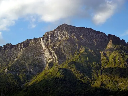
Monte Dolada Fflavio74 · CC BY-SA 3.0

Climate of Fortogna
Best months for sightseeingBest months for sightseeing: May–September.
This month · November
A cold month
Day 10° · Night 3° · Rain 80 mm
- Hottest month
- July (day 26°)
- Coldest month
- January (night -1°)
- Wettest month
- June (117 mm)
- Driest month
- January (44 mm)
Bars: average monthly low and high temperature. Below: precipitation. Monthly averages for 1970–2000 at about 18 km resolution, adjusted for elevation. Highlighted months are mild and relatively dry. Source: WorldClim 2.1 (CC BY 4.0).
Show values as a table
| Month | Jan | Feb | Mar | Apr | May | Jun | Jul | Aug | Sep | Oct | Nov | Dec |
|---|---|---|---|---|---|---|---|---|---|---|---|---|
| Average high (°C) | 6° | 8° | 11° | 15° | 20° | 23° | 26° | 26° | 22° | 17° | 10° | 7° |
| Average low (°C) | -1° | 0° | 3° | 6° | 11° | 14° | 17° | 16° | 13° | 9° | 3° | 0° |
| Precipitation (mm) | 44 | 44 | 57 | 75 | 103 | 117 | 117 | 112 | 100 | 100 | 80 | 50 |
Other places to visit in this season: May June July August September
How to get to Fortogna
The nearest airport is Treviso Airport (TSF), 65 km to the south as the crow flies. The nearest large city is Innsbruck, 134 km to the northwest.
Airports
- Treviso Airport (TSF) Treviso (TV) 65 kmsouth
- Bolzano Airport (BZO) Bolzano (BZ) 78 kmwest
- Venice Marco Polo Airport (VCE) Venezia (VE) 81 kmsouth
Nearby large cities
- Innsbruck Population: 132.5K 134 kmnorthwest
- Klagenfurt Population: 100.3K 161 kmeast
- Ljubljana Population: 272.2K 172 kmeast
- Salzburg Population: 157.2K 184 kmnorth
- Rijeka Population: 108K 195 kmsoutheast
Straight-line distances; road distances are longer. Airport data: OurAirports.
Day trips from Fortogna
Within 100 km: 80 historic and cultural sites, 2,047 natural sites, 188 lakes, rivers and coasts.
0–25 km137 places
- Monte Sambuga Mountain 20 kmS
- Monte Cor Mountain 23 kmS
- Monte Cimone Mountain 25 kmS
- Monte Croce Mountain 18 kmS
25–60 km566 places
- Piz Gralba Mountain 50 kmNW
- Piz Miara Mountain 50 kmNW
- Croda Nera Mountain 45 kmNW
- Thurntaler Seen Lake 60 kmN
60–100 km1,612 places
- Burano Island 83 kmS
- Sacca Fisola Island 89 kmS
- San Clemente Island 91 kmS
- Prestreljenik Mountain 92 kmE
Straight-line distances.
Nearby attractions & nature
Everything nearby-
Monte Beccola Mountain, Longarone3.6 km W
-
Monte Cimon Mountain, Longarone3.8 km W
-
Cima Mora Mountain, Longarone4.3 km E
-
Monte Dolada Mountain, Soverzene5.4 km SE
-
Coll Mai Mountain, Soverzene5.8 km E
-
Cima dell'Albero Mountain, Longarone7.7 km N
Sources & licences
Data last updated: · 2 independent sources