Kusatsu Machi
Local name: 草津町
Located in Agatsuma-gun, Gunma Coordinates: 36°37′10″ N 138°34′17″ E
- Population
- 6,898
- 6.9K
- Elevation
- 1,460 m
- above sea level
- Local time
- UTC+09:00
- Asia/Tokyo · UTC+09:00
- Places inside
- 1
- listed under Kusatsu Machi
- Airports
- MMJ Shinshu-Matsumoto Airport77 km
- TOY Toyama Kitokito Airport124 km
About Kusatsu Machi
Kusatsu Machi is a municipality. Location: Agatsuma-gun, Gunma. Population: 6,898. Elevation: 1,460 m.
Kusatsu (草津町, Kusatsu-machi) is a town located in Gunma Prefecture, Japan. In September 2020, the town had a population of 6,255, in 3,407 households, and a population density of 130 persons per km2. The total area of the town is 249.75 square kilometres (96.43 sq mi). Kusatsu is one of the most famous hot springs resorts in Japan.
Source: Wikipedia · CC BY-SA 4.0
Photos of Kusatsu Machi
-
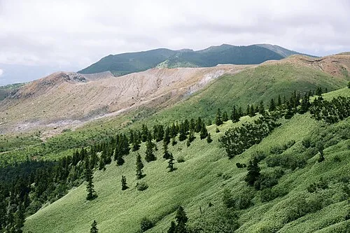
Mount Kusatsu-Shirane 663highland · CC BY 2.5

Travel notes for Kusatsu Machi
From Wikivoyage
Kusatsu (草津) is a famous hot-spring resort town in Gunma, Japan. It is one of the Three Famous Springs (三名泉) in the 17th-century ranking of Hayashi Razan, and remains highly rated and popular.
Understand+
Kusatsu is an onsen town, about 1,200 metres above sea level, beside several volcanoes including the active Mt. Kusatsu-Shirane (Shirane), and known for its healing waters. Water for the town originates from Mt. Shirane with a flow of more than 32,000 litres per minute. This is one of the largest natural outputs of hot spring water in Japan. The water is very acidic, having a sterilizing effect. A 6-inch nail is said to dissolve to only a small metal shard after 10 days.
During the Edo period, Kusatsu became famous for its therapeutic waters. One of the shoguns at the time was said to have shipped its waters to his castle to bathe. Then, in the Meiji period, a German court physician to the emperor, Dr. Erwin Bälz, popularized the healing effects of the water even more by researching and championing its healing properties. Today, Kusatsu continues to be a popular hot spring destination, with upwards to 3 million visitors a year.
Tourist information site:
The local tourist association has a Japanese-only portal site.
Get in+
By rail:
Unusually enough for Japan, Kusatsu does not have a train station of its own. The nearest station is 1 Naganohara-Kusatsuguchi Station (長野原草津口駅) on the JR Agatsuma Line. The limited express Kusatsu runs twice in the morning (10:00 and 12:12) from Ueno Station in Tokyo, taking 2 hr 20 min and costing ¥5,070, from which you can take a connecting bus (25 min, ¥710) to Kusatsu. At any other time, you'll have to take the Shinkansen to Takasaki and transfer to local services (3 hours, ¥5,810), or the Hokuriku Shinkansen to Karuizawa (about 70–80 minutes, ¥5,710) and arrange further transport, or take local trains with 2 or 3 transfers (3½ hours, ¥3,020).
By bus:
2 Kusatsu Onsen Bus Terminal JR operates the Jōshu Yūmeguri (上州ゆめぐり) direct bus to Kusatsu bus terminal several times a day (hourly) from Shinjuku (Tokyo) Expressway Bus Terminal, which takes around 4 hours and charges between ¥3,000 (in advance) and ¥3,600 (on board). Buses also connect from Kusatsu to Naganohara-Kusatsuguchi (¥710) and Karuizawa (¥2240) to link with the rail lines.
Source: Wikivoyage · CC BY-SA 4.0 · abridged
Places bordering Kusatsu Machi
- Naganohara Machi
- Nakanojō
- Tsumagoi Mura
- Takayama Mura
Population of Kusatsu Machi over time
| 2010 | 7,160 | |
|---|---|---|
| 2015 | 6,518 | |
| 2021 | 6,058 |
Censuses and official estimates; source: Wikidata.
Climate of Kusatsu Machi
Best months for sightseeingBest months for sightseeing: July–August.
This month · November
A cold month
Day 8° · Night -3° · Rain 70 mm
Better nearby cities in November
- Kofu · 106 km south17°
- Isehara · 151 km southeast18°
- Fujinomiya · 156 km south18°
- Hottest month
- August (day 23°)
- Coldest month
- January (night -11°)
- Wettest month
- September (206 mm)
- Driest month
- December (47 mm)
Bars: average monthly low and high temperature. Below: precipitation. Monthly averages for 1970–2000 at about 18 km resolution, adjusted for elevation. Highlighted months are mild and relatively dry. Source: WorldClim 2.1 (CC BY 4.0).
Show values as a table
| Month | Jan | Feb | Mar | Apr | May | Jun | Jul | Aug | Sep | Oct | Nov | Dec |
|---|---|---|---|---|---|---|---|---|---|---|---|---|
| Average high (°C) | -1° | -1° | 3° | 10° | 16° | 18° | 22° | 23° | 18° | 13° | 8° | 2° |
| Average low (°C) | -11° | -11° | -8° | -2° | 4° | 9° | 13° | 14° | 10° | 3° | -3° | -7° |
| Precipitation (mm) | 59 | 65 | 78 | 100 | 119 | 188 | 203 | 199 | 206 | 124 | 70 | 47 |
How to get to Kusatsu Machi
The nearest airport is Shinshu-Matsumoto Airport (MMJ), 77 km to the southwest as the crow flies. For international flights: Niigata Airport (KIJ) (156 km). The nearest large city is Nagano, 35 km to the west.
Airports
- Shinshu-Matsumoto Airport (MMJ) Matsumoto 77 kmsouthwest
- Toyama Kitokito Airport (TOY) Toyama 124 kmwest
- Niigata Airport (KIJ) Niigata 156 kmnorth
Nearby large cities
- Nagano Population: 372.8K 35 kmwest
- Ueda Population: 157.5K 35 kmsouthwest
- Takasaki Population: 373K 51 kmsoutheast
- Maebashi Population: 332.1K 52 kmsoutheast
- Isesaki Population: 211.8K 66 kmsoutheast
Straight-line distances; road distances are longer. Airport data: OurAirports.
Day trips from Kusatsu Machi
Within 100 km: 3 historic and cultural sites, 59 natural sites, 12 lakes, rivers and coasts.
0–25 km4 places
- Mount Asama Mountain 24 kmS
- Mount Kusatsu-Shirane Mountain 5 kmNW
- Takama Yama Mountain 11 kmSE
- Azumaya San Mountain 16 kmSW
25–60 km18 places
- Mount Myōgi Mountain 40 kmSE
- Mount Hotaka Mountain 54 kmNE
- Lake Nojiri Lake 39 kmNW
- Tanigawa Dake Mountain 40 kmNE
60–100 km52 places
- Honshu Island 86 kmSW
- Umeda Ko Lake 77 kmE
- Mount Bukō Mountain 88 kmSE
- Mount Nokogiri Mountain 99 kmS
Straight-line distances.
Places in Kusatsu Machi
1 placeBar: population relative to the most populous place in this list.
Nearby attractions & nature
Everything nearby-
Mount Kusatsu-Shirane Mountain, Gunma4.8 km NW
-
Takama Yama Mountain, Naganohara Machi11 km SE
-
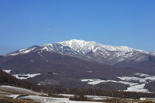 Azumaya San Mountain, Tsumagoi Mura16 km SW
-
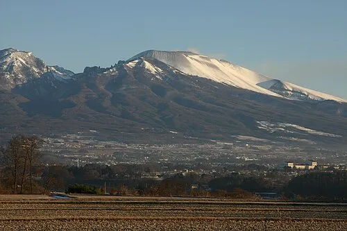 Mount Asama Mountain, Karuizawa Machi24 km S
Other cities and towns in Agatsuma-gun
-
Higashiagatsuma Machi Municipality, Agatsuma-gun22 km SE
-
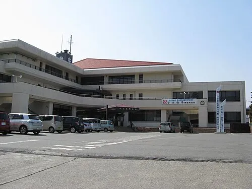 Nakanojō Town, Nakanojō Machi24 km E
-
Takayama Mura Municipality, Agatsuma-gun33 km E
Sources & licences
Data last updated: · 2 independent sources