Kitahiroshima
Local name: 北広島市
Located in Kitahiroshima-shi, Hokkaido Coordinates: 42°58′33″ N 141°34′02″ E
- Population
- 58,918
- 58.9K
- Elevation
- 19 m
- above sea level
- Local time
- UTC+09:00
- Asia/Tokyo · UTC+09:00
- Airports
- OKD Sapporo Okadama Airport22 km
- CTS New Chitose Airport25 km
About Kitahiroshima
Kitahiroshima is a city. Location: Kitahiroshima-shi, Hokkaido. Population: 58,918. Elevation: 19 m.
Kitahiroshima (北広島市, Kitahiroshima-shi) is a city located in Ishikari, Hokkaido, Japan. It is a suburb of Sapporo, adjoining the prefectural capital directly to the east. The city's name has a literal meaning of "North Hiroshima City".
Source: Wikipedia · CC BY-SA 4.0
At a glance
- Built
- 1996
- Area
- 119 km²
- Official website
- city.kitahiroshima.hokkaido.jp
Source: Wikidata
Photos of Kitahiroshima
-

Ray Swi-hymn from Sijhih-Taipei, Taiwan · CC BY-SA 2.0 -

Benlisquare · CC BY-SA 4.0 -

禁樹なずな · CC BY-SA 4.0 -

禁樹なずな · CC BY-SA 4.0 -

掬茶 · CC BY-SA 4.0


Travel notes for Kitahiroshima
From Wikivoyage
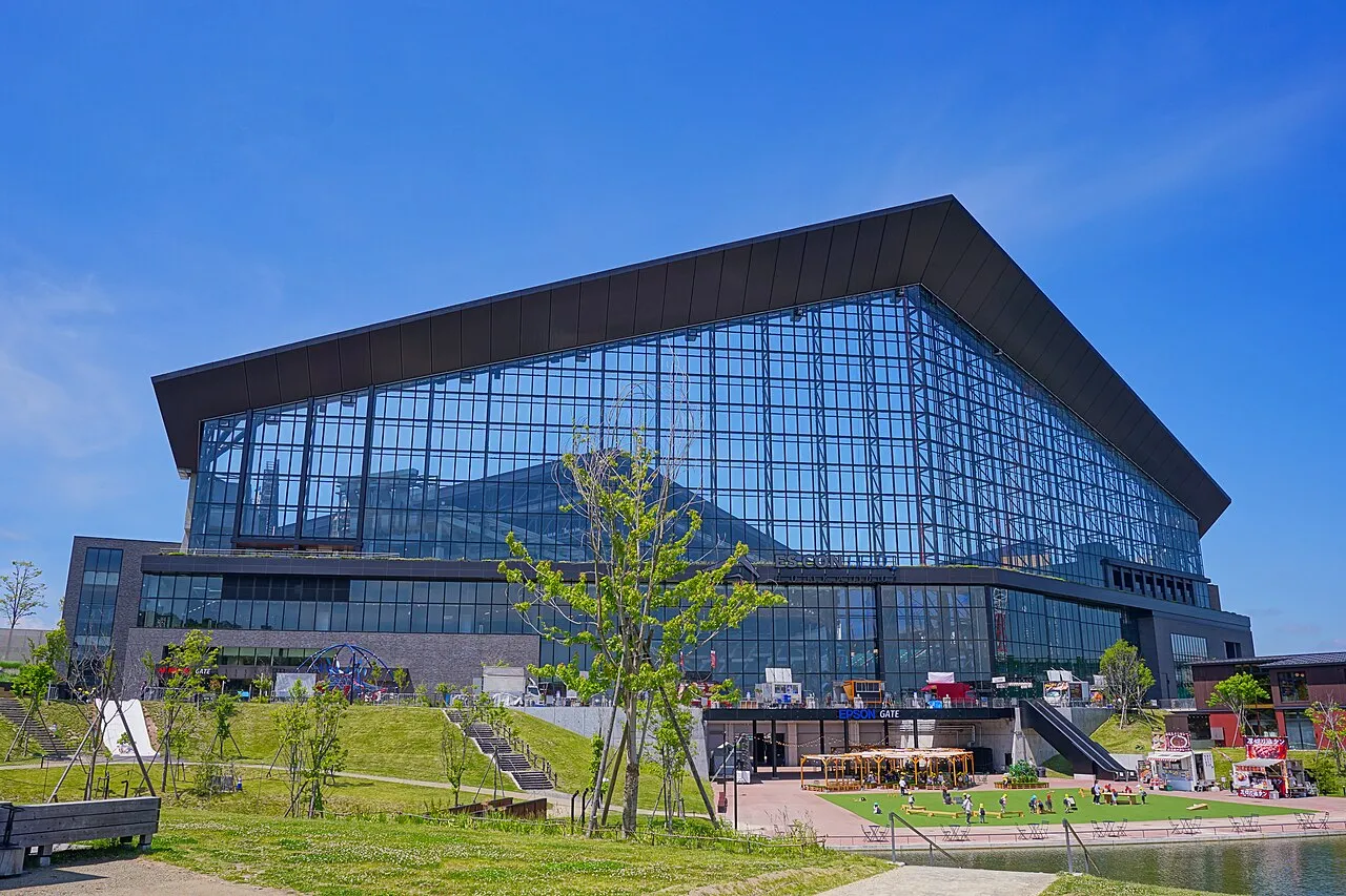
Kitahiroshima (北広島) is a city bordering Sapporo in the central part of Hokkaido, and famous as the home ground of the Hokkaido Nippon-Ham Fighters. The city’s motto, “The Ambitious City,” comes from the famous phrase “Boys, be ambitious” spoken by William S. Clark when he bid farewell to students in Hokkaido, an episode tied to the area’s history.
Understand+
Kitahiroshima is a suburban city in central Hokkaido, between Sapporo and Chitose. Many residents commute to Sapporo for work or study, giving the city its character as a “bed town” for the region’s capital.
The city is surrounded by gentle hills and farmland, reflecting its roots as an agricultural settlement. Kitahiroshima has developed rapidly, most notably with large-scale sports and commercial facilities connected to the Hokkaido Nippon-Ham Fighters.
History:
Kitahiroshima’s origins go back to the Meiji period, when settlers from Hiroshima Prefecture moved north in search of new lands. In 1884, about 25 families (107 people) migrated and laid the groundwork for what eventually became the village of Hiroshima in central Hokkaido.
In 1894, Hiroshima Village was officially founded. Over time the population and infrastructure grew, and in 1968, the village was renamed Hiroshima Town.
Finally, on September 1, 1996, Hiroshima Town was promoted to city status. Because there was already another city named Hiroshima in Hiroshima Prefecture (on the other side of Japan), the new city was renamed Kitahiroshima (literally “North Hiroshima”).
Climate:
Kitahiroshima has a humid continental climate with four distinct seasons with warm, humid summers and cold, snowy winters. Snow usually starts in November and lasts until March.
Daylight hours vary greatly through the year — summer days are long and bright, while winter days are short, with sunsets before 17:00.
Get in+
Kitahiroshima is just east of Sapporo.
By train:
JR Chitose Line trains run frequently to Kita‑Hiroshima Station from both Sapporo and New Chitose Airport; Rapid Airport services take about 18–21 minutes and run every 15–20 minutes in daytime hours.¥1420.
From Sapporo. Board a Rapid Airport or local JR train from Sapporo Station to Kita‑Hiroshima; typical journey time is around 18 minutes, with departures several times per hour.
From New Chitose Airport. Take the JR Rapid Airport from the airport station directly to Kita‑Hiroshima in roughly 21 minutes; trains operate all day at regular intervals.
To ES CON Field. From Kita‑Hiroshima Station, walk along the signposted Elfin Road or use the short shuttle bus from the West Exit; the shuttle takes about 5 minutes and runs on game and event days with a small fare.
1 JR Kita-Hiroshima Station (北広島駅), ☏ +81 11-372-3156. 7:00 - 17:30. is the main railway station of Kita-hiroshima. (updated Oct 2025)
By bus:
Event shuttles also operate from hubs such as Shin‑Sapporo and sometimes from New Chitose Airport on game days; check current timetables before traveling.
On Fighters game days or during large-scale events, dedicated shuttle buses operate between Kitahiroshima Station and F Village, offering a direct, crowd-friendly option for travelers.
Hokkaido Chuo Bus: Runs regular services between Sapporo Station, Fukuzumi, and Kitahiroshima Station. Seasonal and event-day buses also serve Es Con Field HOKKAIDO.
Airport Limousine Bus (seasonal): Operates during major games or large-scale events, providing direct access between New Chitose Airport and F Village.
By car:
Kita-hiroshima is 44 minutes away from Sapporo by car with using route 12.
Driving from central Sapporo or New Chitose Airport takes roughly 20–25 minutes in normal traffic; parking at ES CON Field may require advance reservation and can be congested on game days.
Source: Wikivoyage · CC BY-SA 4.0 · abridged
Places bordering Kitahiroshima
- Ebetsu
- Sapporo
- Eniwa-shi
- Nanporo Chō
- Naganuma
Twin towns and sister cities of Kitahiroshima
- Higashihiroshima· Japan
Source: Wikidata. Only places with a page on this site are shown.
Population of Kitahiroshima over time
| 2010 | 60,353 | |
|---|---|---|
| 2015 | 59,064 | |
| 2020 | 58,125 |
Censuses and official estimates; source: Wikidata.
Climate of Kitahiroshima
Best months for sightseeingBest months for sightseeing: June–September.
This month · November
A wet month
Day 8° · Night -1° · Rain 103 mm
- Hottest month
- August (day 24°)
- Coldest month
- January (night -12°)
- Wettest month
- August (166 mm)
- Driest month
- March (62 mm)
Bars: average monthly low and high temperature. Below: precipitation. Monthly averages for 1970–2000 at about 18 km resolution, adjusted for elevation. Highlighted months are mild and relatively dry. Source: WorldClim 2.1 (CC BY 4.0).
Show values as a table
| Month | Jan | Feb | Mar | Apr | May | Jun | Jul | Aug | Sep | Oct | Nov | Dec |
|---|---|---|---|---|---|---|---|---|---|---|---|---|
| Average high (°C) | -2° | -1° | 3° | 10° | 16° | 19° | 23° | 24° | 21° | 15° | 8° | 1° |
| Average low (°C) | -12° | -11° | -6° | 1° | 6° | 11° | 16° | 17° | 12° | 5° | -1° | -8° |
| Precipitation (mm) | 79 | 64 | 62 | 73 | 83 | 83 | 119 | 166 | 147 | 113 | 103 | 91 |
Other places to visit in this season: June July August September
How to get to Kitahiroshima
The nearest airport is Sapporo Okadama Airport (OKD), 22 km to the northwest as the crow flies. For international flights: New Chitose Airport (CTS) (25 km). The nearest large city is Ebetsu, 15 km to the north.
Airports
- Sapporo Okadama Airport (OKD) Sapporo 22 kmnorthwest
- New Chitose Airport (CTS) Sapporo 25 kmsoutheast
- Asahikawa Airport (AKJ) Higashikagura 105 kmnortheast
Nearby large cities
- Ebetsu Population: 134K 15 kmnorth
- Sapporo Population: 2M 20 kmnorthwest
- Tomakomai Population: 174.8K 38 kmsouth
- Otaru Population: 115.3K 52 kmnorthwest
- Asahikawa Population: 333.5K 109 kmnortheast
Straight-line distances; road distances are longer. Airport data: OurAirports.
Day trips from Kitahiroshima
Within 100 km: 2 historic and cultural sites, 22 natural sites, 12 lakes, rivers and coasts.
0–25 km5 places
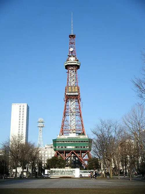
- Sapporo TV Tower Landmark 20 kmNW
- Yūbari River River 16 kmN
- Toyohira River River 18 kmN
- Chitose River River 6 kmN
25–60 km10 places
- Zenibako River River 37 kmNW
- Mount Shiribetsu Mountain 58 kmSW
- Mount Monbetsu Mountain 25 kmSW
- Mount Eniwa Mountain 32 kmSW
60–100 km21 places
- Kuttara-ko Lake 62 kmSW
- Saru River River 64 kmSE
- Mount Tomamu Mountain 85 kmE
- Mount Rubeshibe Mountain 89 kmNE
Straight-line distances.
Kitahiroshima and similar cities
Side by side with cities of similar size in the same country: population, elevation and climate.
| Measure | Kitahiroshima | Minami-Sōma | Koga | Ishikari |
|---|---|---|---|---|
| Population | 58.9K | 59K | 58.8K | 58.8K |
| Elevation | 19 m | 27 m | 10 m | 0 m |
| Summer day (hottest month) | 24° | 28° | 30° | 25° |
| Winter night (coldest month) | -12° | -2° | 3° | -9° |
| Annual rainfall | 1,183 mm | 1,266 mm | 1,679 mm | 1,210 mm |
| Best months | Jun–Sep | May–Jul, Sep–Oct | May–Jun, Oct | Jun–Sep |
| Distance | — | 596 km | 1,410 km | 34 km |
Climate values are 1970–2000 monthly averages; straight-line distance.
Nearby attractions & nature
Everything nearby-
Chitose River River, Japan5.5 km N
-
Toyohira River River, Japan18 km N
-
 Sapporo TV Tower Landmark, Chūō Ku20 km NW
-
 Hokkaido University Botanical Gardens Attraction, Chūō Ku21 km NW
-
Yūbari River River, Japan16 km N
Sources & licences
Data last updated: · 2 independent sources