- Population
- 16,567
- 16.6K
- Elevation
- 8 m
- above sea level
- Local time
- UTC+09:00
- Asia/Tokyo · UTC+09:00
- Airports
- KIX Kansai International Airport16 km
- UKB Kobe Airport23 km
About Tadaoka-higashi
Tadaoka-higashi is a town. Location: Tadaoka Chō, Senboku-gun. Population: 16,567. Elevation: 8 m. The best months to visit are May, October. The nearest airport is Kansai International Airport (16 km). Nearby sights include Yamato Gawa and PL Peace Tower.
Climate of Tadaoka-higashi
Best months for sightseeingBest months for sightseeing: May, October.
This month · November
Outside the best season
Day 17° · Night 9° · Rain 77 mm
Better nearby cities in November
- Kochi · 201 km southwest18°
- Fujinomiya · 305 km east18°
- Fuji · 309 km east20°
- Hottest month
- August (day 32°)
- Coldest month
- January (night 2°)
- Wettest month
- June (232 mm)
- Driest month
- December (39 mm)
Bars: average monthly low and high temperature. Below: precipitation. Monthly averages for 1970–2000 at about 18 km resolution, adjusted for elevation. Highlighted months are mild and relatively dry. Source: WorldClim 2.1 (CC BY 4.0).
Show values as a table
| Month | Jan | Feb | Mar | Apr | May | Jun | Jul | Aug | Sep | Oct | Nov | Dec |
|---|---|---|---|---|---|---|---|---|---|---|---|---|
| Average high (°C) | 10° | 10° | 13° | 19° | 24° | 27° | 31° | 32° | 28° | 23° | 17° | 12° |
| Average low (°C) | 2° | 2° | 4° | 10° | 15° | 19° | 23° | 24° | 20° | 14° | 9° | 4° |
| Precipitation (mm) | 45 | 58 | 100 | 143 | 153 | 232 | 169 | 121 | 203 | 124 | 77 | 39 |
How to get to Tadaoka-higashi
The nearest airport is Kansai International Airport (KIX), 16 km to the southwest as the crow flies. The nearest large city is Izumi, 3 km to the east.
Airports
- Kansai International Airport (KIX) Osaka 16 kmsouthwest
- Kobe Airport (UKB) Kobe 23 kmnorthwest
- Osaka Itami International Airport (ITM) Osaka 33 kmnorth
Nearby large cities
- Izumi Population: 184.6K 3 kmeast
- Kishiwada Population: 205.6K 4 kmsouthwest
- Izumisano Population: 100.1K 11 kmsouthwest
- Matsubara Population: 130.9K 16 kmnortheast
- Kawachi-Nagano Population: 101.7K 18 kmeast
Straight-line distances; road distances are longer. Airport data: OurAirports.
Day trips from Tadaoka-higashi
Within 100 km: 31 historic and cultural sites, 41 natural sites, 17 lakes, rivers and coasts.
0–25 km7 places
- Osaka Bay Natural site 24 kmW
- Mukogawa River River 22 kmN
- Tenpō Zan Mountain 19 kmN
- Yodo River River 22 kmN
25–60 km40 places
- Awaji Island Island 54 kmW
- Mount Rokkō Mountain 35 kmN
- Mount Miwa Mountain 43 kmE
- Mount Amanokagu Mountain 39 kmE
60–100 km42 places
- Mount Ōdaigahara Mountain 70 kmSE
- Mount Kunimi Mountain 73 kmE
- Mount Azami Mountain 63 kmE
- Takami Yama Mountain 64 kmE
Straight-line distances.
Nearby attractions & nature
Everything nearby-
 Yamato Gawa River, Japan14 km N
-
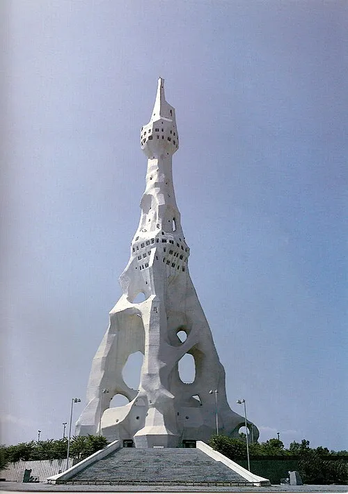 PL Peace Tower Landmark, Tondabayashi Shi17 km E
-
Tenpō Zan Mountain, Minato-ku19 km N
-
Kizu River River, Osaka16 km N
-
Yodo River River, Japan22 km N
-
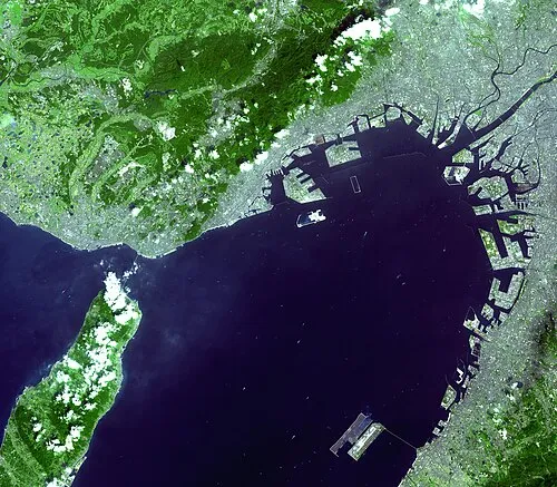 Osaka Bay Natural site, Japan24 km W
-
Mukogawa River River, Hyōgo22 km N
Sources & licences
Data last updated: