Gmina Zielonki
Located in Kraków County, Lesser Poland Voivodeship Coordinates: 50°08′32″ N 19°56′39″ E
- Population
- 22,222
- 22.2K
- Elevation
- 290 m
- above sea level
- Local time
- UTC+01:00
- Europe/Warsaw · UTC+01:00
- Places inside
- 5
- listed under Gmina Zielonki
- Airports
- KRK Kraków John Paul II International Airport13 km
- KTW Katowice Wojciech Korfanty International Airport72 km
About Gmina Zielonki
Gmina Zielonki is a municipality. Location: Kraków County, Lesser Poland Voivodeship. Population: 22,222. Elevation: 290 m. The best months to visit are May–September. The nearest airport is Kraków John Paul II International Airport (13 km). Nearby sights include Craców Ghetto and Plaszow Concentration Camp.
Photos of Gmina Zielonki
-
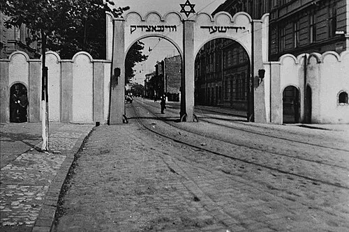
Craców Ghetto Unknown author Unknown author · Public domain

Climate of Gmina Zielonki
Best months for sightseeingBest months for sightseeing: May–September.
This month · November
A cold month
Day 7° · Night 0° · Rain 40 mm
- Hottest month
- July (day 24°)
- Coldest month
- January (night -6°)
- Wettest month
- June (98 mm)
- Driest month
- February (31 mm)
Bars: average monthly low and high temperature. Below: precipitation. Monthly averages for 1970–2000 at about 18 km resolution, adjusted for elevation. Highlighted months are mild and relatively dry. Source: WorldClim 2.1 (CC BY 4.0).
Show values as a table
| Month | Jan | Feb | Mar | Apr | May | Jun | Jul | Aug | Sep | Oct | Nov | Dec |
|---|---|---|---|---|---|---|---|---|---|---|---|---|
| Average high (°C) | 2° | 3° | 8° | 14° | 20° | 23° | 24° | 24° | 19° | 14° | 7° | 3° |
| Average low (°C) | -6° | -5° | -1° | 3° | 8° | 11° | 13° | 12° | 8° | 4° | 0° | -4° |
| Precipitation (mm) | 38 | 31 | 35 | 50 | 73 | 98 | 93 | 80 | 60 | 50 | 40 | 39 |
Other places to visit in this season: May June July August September
How to get to Gmina Zielonki
The nearest airport is Kraków John Paul II International Airport (KRK), 13 km to the southwest as the crow flies. The nearest large city is Košice, 185 km to the southeast.
Airports
- Kraków John Paul II International Airport (KRK) Balice 13 kmsouthwest
- Katowice Wojciech Korfanty International Airport (KTW) Katowice 72 kmnorthwest
- Poprad-Tatry Airport (TAT) Poprad 121 kmsouth
Nearby large cities
- Košice Population: 225K 185 kmsoutheast
- Miskolc Population: 154.5K 235 kmsouth
- Brno Population: 404.3K 263 kmwest
- Nyíregyháza Population: 117.7K 276 kmsoutheast
- Bratislava Population: 423.7K 303 kmsouthwest
Straight-line distances; road distances are longer. Airport data: OurAirports.
Day trips from Gmina Zielonki
Within 100 km: 98 historic and cultural sites, 239 natural sites.
0–25 km11 places
- Góra Chełmowa Mountain 11 kmNW
- Czyżowa Mountain 18 kmW
- Powroźnikowa Mountain 21 kmW
- Łyse Skały Mountain 17 kmNW
25–60 km75 places
- Smerkowiec Mountain 57 kmSW
- Kostrza Mountain 48 kmSE
- Na Beskidzie Mountain 56 kmSW
- Łysina Mountain 41 kmS
60–100 km251 places
- Beskids Mountain 84 kmS
- Červený Kláštor Attraction 89 kmS
- Obidowiec Mountain 65 kmS
- Jaworzyna Mountain 79 kmS
Straight-line distances.
Places in Gmina Zielonki
5 placesBar: population relative to the most populous place in this list.
Nearby attractions & nature
Everything nearby-
Craców Ghetto Historic site, Prądnik Biały6.8 km S
-
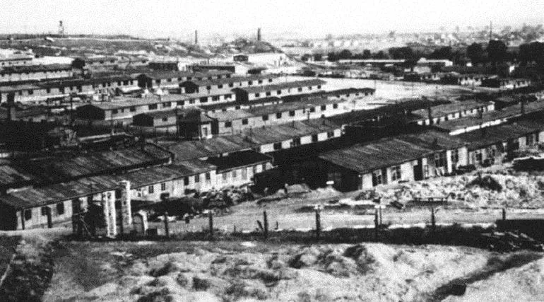 Plaszow Concentration Camp Historic site, Podgórze12 km S
-
Góra Chełmowa Mountain, Gmina Skała11 km NW
-
Krakau Concentration Camp (Kabelwerke) Historic site, Stare Miasto8.6 km S
-
Łyse Skały Mountain, Gmina Jerzmanowice-Przeginia17 km NW
-
Czyżowa Mountain, Gmina Krzeszowice18 km W
-
Powroźnikowa Mountain, Gmina Jerzmanowice-Przeginia21 km W
-
Wieliczka Concentration Camp Historic site, Wieliczka19 km SE
Sources & licences
Data last updated: