Pico do Larano
Located in Machico, Machico Municipality Coordinates: 32°44′00″ N 16°47′00″ W
- Elevation
- 88 m
- above sea level
- Local time
- UTC+00:00
- Atlantic/Madeira · UTC+00:00
- Airports
- FNC Cristiano Ronaldo International Airport4 km
- PXO Porto Santo Airport55 km
About Pico do Larano
Pico do Larano is a mountain. Location: Machico, Machico Municipality. Elevation: 88 m. The best months to visit are May–October. The nearest airport is Cristiano Ronaldo International Airport (4 km). Nearby sights include Pico das Roçadas and Pico do Castanho.
Photos of Pico do Larano
-
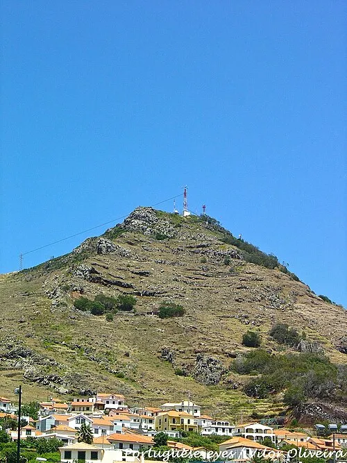
Pico do Facho Vitor Oliveira from Torres Vedras, PORTUGAL · CC BY-SA 2.0

Climate of Pico do Larano
Best months for sightseeingBest months for sightseeing: May–October.
This month · November
Outside the best season
Day 21° · Night 17° · Rain 86 mm
- Hottest month
- August (day 25°)
- Coldest month
- February (night 14°)
- Wettest month
- December (103 mm)
- Driest month
- July (4 mm)
Bars: average monthly low and high temperature. Below: precipitation. Monthly averages for 1970–2000 at about 18 km resolution, adjusted for elevation. Highlighted months are mild and relatively dry. Source: WorldClim 2.1 (CC BY 4.0).
Show values as a table
| Month | Jan | Feb | Mar | Apr | May | Jun | Jul | Aug | Sep | Oct | Nov | Dec |
|---|---|---|---|---|---|---|---|---|---|---|---|---|
| Average high (°C) | 18° | 18° | 19° | 19° | 20° | 22° | 24° | 25° | 25° | 23° | 21° | 20° |
| Average low (°C) | 14° | 14° | 14° | 14° | 16° | 18° | 19° | 20° | 20° | 19° | 17° | 15° |
| Precipitation (mm) | 91 | 68 | 63 | 41 | 26 | 12 | 4 | 7 | 48 | 79 | 86 | 103 |
Other places to visit in this season: May June July August September October
How to get to Pico do Larano
The nearest airport is Cristiano Ronaldo International Airport (FNC), 4 km to the south as the crow flies.
Airports
- Cristiano Ronaldo International Airport (FNC) Funchal 4 kmsouth
- Porto Santo Airport (PXO) Vila Baleira 55 kmnortheast
Straight-line distances; road distances are longer. Airport data: OurAirports.
Day trips from Pico do Larano
Within 100 km: 5 historic and cultural sites, 39 natural sites, 1 lake, river or coast.
0–25 km16 places
- Pico da Volta da Malhada Mountain 17 kmW
- Pico das Torrinhas Mountain 17 kmW
- Pico Ruivo Mountain 15 kmW
- Pico das Roçadas Mountain 2 kmE
25–60 km29 places
- Espigão Mountain 50 kmNE
- Pico de Ana Ferreira Mountain 51 kmNE
- Pico Gordo Mountain 34 kmW
- Pico da Urze Mountain 31 kmW
Straight-line distances.
Nearest towns and villages
-
Machico Town, Machico2.4 km SE
-
Água de Pena Municipality, Machico Municipality2.3 km S
-
Santa Cruz Municipality, Santa Cruz Municipality4.4 km SW
-
 Caniçal Village, Caniçal4.3 km E
-
Água de Pena Village, Santa Cruz3.6 km S
-
Caniçal Municipality, Machico Municipality4.3 km E
Nearby attractions & nature
Everything nearby-
Pico das Roçadas Mountain, Machico1.6 km E
-
Pico do Castanho Mountain, Machico1.6 km E
-
Pico do Facho Mountain, Madeira3.6 km SE
-
Cabeço de Cancela Mountain, Madeira4.7 km E
-
Pico João do Prado Mountain, Camacha8.6 km SW
-
Pico Ruivo Mountain, Faial15 km W
-
Pico do Cedro Mountain, Santo António16 km W
-
Pico do Canário Mountain, São Jorge16 km W
Sources & licences
Data last updated: · 2 independent sources