Serra da Mina
Located in Alegrete, Portalegre Municipality Coordinates: 39°13′51″ N 7°16′00″ W
- Elevation
- 501 m
- above sea level
- Local time
- UTC+00:00
- Europe/Lisbon · UTC+00:00
- Airports
- BJZ Badajoz Airport54 km
- LIS Lisbon Humberto Delgado Airport169 km
About Serra da Mina
Serra da Mina is a mountain. Location: Alegrete, Portalegre Municipality. Elevation: 501 m. The best months to visit are May–October. The nearest airport is Badajoz Airport (54 km). Nearby sights include Castelo de Alegrete and Alto do Casqueijal.
Photos of Serra da Mina
-
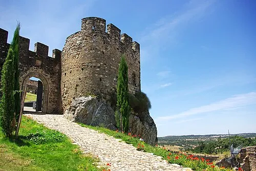
Castelo de Alegrete Inacio Pires · CC BY-SA 3.0

Climate of Serra da Mina
Best months for sightseeingBest months for sightseeing: May–October.
This month · November
Outside the best season
Day 15° · Night 8° · Rain 93 mm
- Hottest month
- July (day 30°)
- Coldest month
- January (night 5°)
- Wettest month
- December (98 mm)
- Driest month
- July (6 mm)
Bars: average monthly low and high temperature. Below: precipitation. Monthly averages for 1970–2000 at about 18 km resolution, adjusted for elevation. Highlighted months are mild and relatively dry. Source: WorldClim 2.1 (CC BY 4.0).
Show values as a table
| Month | Jan | Feb | Mar | Apr | May | Jun | Jul | Aug | Sep | Oct | Nov | Dec |
|---|---|---|---|---|---|---|---|---|---|---|---|---|
| Average high (°C) | 12° | 13° | 16° | 17° | 21° | 26° | 30° | 30° | 26° | 20° | 15° | 12° |
| Average low (°C) | 5° | 5° | 6° | 7° | 10° | 14° | 17° | 17° | 15° | 11° | 8° | 6° |
| Precipitation (mm) | 88 | 75 | 61 | 61 | 55 | 27 | 6 | 7 | 33 | 74 | 93 | 98 |
Other places to visit in this season: May June July August September October
How to get to Serra da Mina
The nearest airport is Badajoz Airport (BJZ), 54 km to the southeast as the crow flies. For international flights: Lisbon Humberto Delgado Airport (LIS) (169 km). The nearest large city is Badajoz, 47 km to the southeast.
Airports
- Badajoz Airport (BJZ) Badajoz 54 kmsoutheast
- Lisbon Humberto Delgado Airport (LIS) Lisbon 169 kmwest
- Aerodromo Goncalves Lobato (Viseu Airport) (VSE) Viseu 174 kmnorth
Nearby large cities
- Badajoz Population: 150.5K 47 kmsoutheast
- Setúbal Population: 118.2K 161 kmsouthwest
- Lisbon Population: 517.8K 173 kmwest
- Huelva Population: 144.3K 220 kmsouth
- Seville Population: 686.7K 234 kmsoutheast
Straight-line distances; road distances are longer. Airport data: OurAirports.
Day trips from Serra da Mina
Within 100 km: 102 historic and cultural sites, 89 natural sites, 100 lakes, rivers and coasts.
0–25 km26 places
- Rio Xévora River 19 kmE
- Arroyo de las Moreras River 20 kmNE
- Ribera de Jola River 13 kmE
- Arroyo Guarranque River 20 kmE
25–60 km87 places
- Sapateira Grande Mountain 27 kmN
- Pantano de la Peña del Águila Lake 34 kmE
- Alpotreque Mountain 43 kmE
- Parque de Castelar Natural site 47 kmSE
60–100 km178 places
- Vale Costado Natural site 99 kmSW
- Pantano de Proserpina Lake 83 kmE
- Laguna Grande Lake 75 kmSE
- Pantano de Cornalvo Lake 98 kmE
Straight-line distances.
Nearest towns and villages
-
Codosera, La Municipality, Badajoz6.5 km E
-
La Codosera Village, Codosera, La8.4 km E
-
União das freguesias de Reguengo e São Julião Municipality, Portalegre Municipality8.9 km NW
-
Mosteiros Municipality, Arronches Municipality7.9 km S
-
La Rabaza Village, Codosera, La5 km NE
-
Esperança Municipality, Arronches Municipality9.6 km SE
Nearby attractions & nature
Everything nearby-
Castelo de Alegrete Historic site, Alegrete5 km W
-
Alto do Casqueijal Mountain, União das freguesias de Reguengo e São Julião8.3 km N
-
Cabeço Alto Mountain, União das freguesias de Reguengo e São Julião8.6 km NW
-
Serra da Chugueira Mountain, Esperança12 km SE
-
Tapada do Mendes Mountain, União das freguesias de Reguengo e São Julião13 km NW
-
Serra da Pedra Torta Mountain, Esperança14 km SE
-
Cabeço do Mourato Mountain, Assunção15 km SE
-
Cabeça Gorda Mountain, União das freguesias de Ribeira de Nisa e Carreiras15 km NW
Sources & licences
Data last updated: · 2 independent sources