Carvalhal de Cima
Located in Rio de Couros, Ourém Municipality Coordinates: 39°44′31″ N 8°31′56″ W
- Population
- 141
- 141
- Elevation
- 175 m
- above sea level
- Local time
- UTC+00:00
- Europe/Lisbon · UTC+00:00
- Airports
- LIS Lisbon Humberto Delgado Airport119 km
- VSE Aerodromo Goncalves Lobato (Viseu Airport)122 km
About Carvalhal de Cima
Carvalhal de Cima is a village. Location: Rio de Couros, Ourém Municipality. Population: 141. Elevation: 175 m. The best months to visit are May–October. The nearest airport is Lisbon Humberto Delgado Airport (119 km). Nearby sights include Outeiro do Talegre and Cabeço do Vento.
Climate of Carvalhal de Cima
Best months for sightseeingBest months for sightseeing: May–October.
This month · November
A wet month
Day 17° · Night 9° · Rain 105 mm
- Hottest month
- August (day 28°)
- Coldest month
- January (night 6°)
- Wettest month
- January (122 mm)
- Driest month
- July (10 mm)
Bars: average monthly low and high temperature. Below: precipitation. Monthly averages for 1970–2000 at about 18 km resolution, adjusted for elevation. Highlighted months are mild and relatively dry. Source: WorldClim 2.1 (CC BY 4.0).
Show values as a table
| Month | Jan | Feb | Mar | Apr | May | Jun | Jul | Aug | Sep | Oct | Nov | Dec |
|---|---|---|---|---|---|---|---|---|---|---|---|---|
| Average high (°C) | 13° | 15° | 17° | 19° | 21° | 25° | 28° | 28° | 26° | 21° | 17° | 14° |
| Average low (°C) | 6° | 7° | 8° | 9° | 11° | 14° | 16° | 16° | 15° | 12° | 9° | 7° |
| Precipitation (mm) | 122 | 102 | 71 | 75 | 69 | 34 | 10 | 11 | 38 | 94 | 105 | 120 |
Other places to visit in this season: May June July August September October
How to get to Carvalhal de Cima
The nearest airport is Lisbon Humberto Delgado Airport (LIS), 119 km to the southwest as the crow flies. The nearest large city is Lisbon, 125 km to the southwest.
Airports
- Lisbon Humberto Delgado Airport (LIS) Lisbon 119 kmsouthwest
- Aerodromo Goncalves Lobato (Viseu Airport) (VSE) Viseu 122 kmnortheast
- Cascais Airport (CAT) Cascais 133 kmsouthwest
Nearby large cities
- Lisbon Population: 517.8K 125 kmsouthwest
- Setúbal Population: 118.2K 139 kmsouth
- Porto Population: 252.7K 156 kmnorth
- Badajoz Population: 150.5K 165 kmsoutheast
- Braga Population: 193.3K 201 kmnorth
Straight-line distances; road distances are longer. Airport data: OurAirports.
Day trips from Carvalhal de Cima
Within 100 km: 23 historic and cultural sites, 144 natural sites.
0–25 km14 places
- Cabeço do Vento Mountain 21 kmSW
- Outeiro do Talegre Mountain 17 kmNE
- Cabeço Sobreiro Mountain 24 kmSW
- Serra de Sicó Mountain 20 kmN
25–60 km48 places
- Botanical Garden of the University of Coimbra Attraction 52 kmN
- Serra da Folgosa Mountain 55 kmNE
- Cabeço Gordo Mountain 33 kmSW
- Cabeço Gordo Mountain 41 kmS
60–100 km105 places
- Castelo de Avô Historic site 81 kmNE
- Alto da Lousa Mountain 87 kmN
- Alto da Louriceira Mountain 86 kmN
- Cabeço das Lamas Mountain 72 kmNE
Straight-line distances.
Nearby attractions & nature
Everything nearby-
Outeiro do Talegre Mountain, Alvaiázere17 km NE
-
Cabeço do Vento Mountain, Fátima21 km SW
-
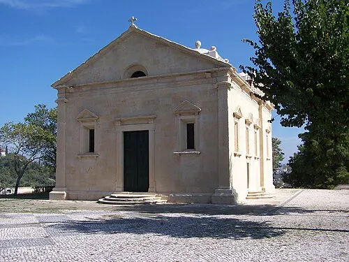 Hermitage of Nossa Senhora da Conceição Attraction, União das freguesias de Tomar (São João Baptista) e Santa Maria dos Olivais18 km SE
-
Serra da Portela Mountain, Pousaflores18 km NE
-
Serra do Castelo Mountain, Pousaflores18 km NE
-
Serra da Quinta Mountain, Chão de Couce20 km NE
Sources & licences
Data last updated: