Slovenj Gradec
Located in Urban Municipality of Slovenj Gradec, Slovenia Coordinates: 46°30′39″ N 15°05′02″ E

- Population
- 7,249
- 7.2K
- Elevation
- 447 m
- above sea level
- Local time
- UTC+01:00
- Europe/Ljubljana · UTC+01:00
- Airports
- MBX Maribor Edvard Rusjan Airport46 km
- LJU Ljubljana Jože Pučnik Airport58 km
About Slovenj Gradec
Slovenj Gradec is a city. Location: Urban Municipality of Slovenj Gradec, Slovenia. Population: 7,249. Elevation: 447 m.
Slovenj Gradec (pronounced [slɔˈʋéːŋ ˈɡɾàːdəts] ; German: Windischgrätz, after about 1900 Windischgraz) is a town in northern Slovenia. It is the centre of the Urban Municipality of Slovenj Gradec. It is part of the historical Styria region, and since 2005 it has belonged to the NUTS-3 Carinthia Statistical Region. It is located in the Mislinja Valley at the eastern end of the Karawanks mountain range, about 45 km (28 mi) west of Maribor and 65 km (40 mi) northeast of Ljubljana.
Source: Wikipedia · CC BY-SA 4.0
At a glance
- Heritage designation
- monument of local significance
- Area
- 174 km²
- Official website
- slovenjgradec.si
Source: Wikidata
Photos of Slovenj Gradec
-

Globetrotter19 · CC BY-SA 3.0 -

Globetrotter19 · CC BY-SA 3.0 -

gez. v. Kuwasseg, lith. v. Folwarczni, published by J. F. Kaiser, Graz, Scan and postprocessing by Hubertl · Public domain -
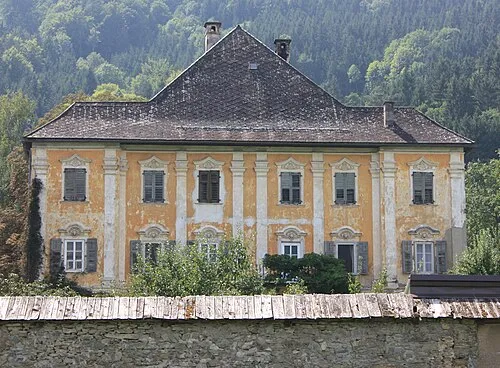
Schloss Eberwein Mefusbren69 · Public domain -

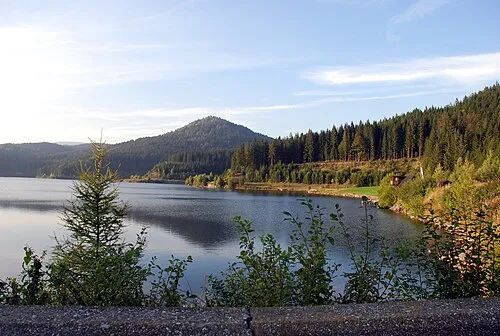
Mislinja Savinjc · CC BY-SA 4.0


Travel notes for Slovenj Gradec
From Wikivoyage
Slovenj Gradec is a town in northern Slovenia.
Get in+
The easiest way to get in Slovenj Gradec is with a car.
There is a railway station in Dravograd (6 mi. North) with daily service to/from Maribor.
2 mi. Southwest of Slovenj Gradec is also a small airport with no regular service, but it is possible to book a private flight with a small aircraft.
Source: Wikivoyage · CC BY-SA 4.0 · abridged
Twin towns and sister cities of Slovenj Gradec
- Várpalota· Hungary
- Gornji Milanovac· Serbia
- Myoko-shi· Japan
Source: Wikidata. Only places with a page on this site are shown.
Climate of Slovenj Gradec
Best months for sightseeingBest months for sightseeing: May–September.
This month · November
A wet month
Day 8° · Night 1° · Rain 105 mm
- Hottest month
- July (day 25°)
- Coldest month
- January (night -4°)
- Wettest month
- July (151 mm)
- Driest month
- January (45 mm)
Bars: average monthly low and high temperature. Below: precipitation. Monthly averages for 1970–2000 at about 18 km resolution, adjusted for elevation. Highlighted months are mild and relatively dry. Source: WorldClim 2.1 (CC BY 4.0).
Show values as a table
| Month | Jan | Feb | Mar | Apr | May | Jun | Jul | Aug | Sep | Oct | Nov | Dec |
|---|---|---|---|---|---|---|---|---|---|---|---|---|
| Average high (°C) | 3° | 6° | 10° | 15° | 20° | 23° | 25° | 25° | 21° | 15° | 8° | 4° |
| Average low (°C) | -4° | -3° | 0° | 4° | 9° | 12° | 14° | 13° | 10° | 5° | 1° | -3° |
| Precipitation (mm) | 45 | 53 | 74 | 91 | 106 | 149 | 151 | 135 | 116 | 111 | 105 | 72 |
Other places to visit in this season: May June July August September
How to get to Slovenj Gradec
The nearest airport is Maribor Edvard Rusjan Airport (MBX), 46 km to the east as the crow flies. For international flights: Ljubljana Jože Pučnik Airport (LJU) (58 km). The nearest large city is Klagenfurt, 61 km to the west.
Airports
- Maribor Edvard Rusjan Airport (MBX) Maribor 46 kmeast
- Ljubljana Jože Pučnik Airport (LJU) Zgornji Brnik 58 kmsouthwest
- Klagenfurt Airport (KLU) Klagenfurt am Wörthersee 59 kmwest
Nearby large cities
- Klagenfurt Population: 100.3K 61 kmwest
- Graz Population: 303.3K 68 kmnortheast
- Ljubljana Population: 272.2K 68 kmsouthwest
- Zagreb Population: 663.6K 104 kmsoutheast
- Rijeka Population: 108K 141 kmsouth
Straight-line distances; road distances are longer. Airport data: OurAirports.
Day trips from Slovenj Gradec
Within 100 km: 223 historic and cultural sites, 878 natural sites, 415 lakes, rivers and coasts.
0–25 km33 places
- Ribnica Lake Lake 14 kmE
- Rogla Mountain 20 kmE
- Črni Vrh Mountain 12 kmE
- Paka River 22 kmS
25–60 km399 places
- Pohorje Mountain 29 kmE
- Mrzla Gora Mountain 42 kmSW
- Grintavec Mountain 45 kmW
- Rača River 54 kmSW
60–100 km1,084 places
- Lake Bohinj Lake 97 kmW
- Lake Bled Lake 78 kmW
- Triglav Mountain 97 kmW
- Šmarna gora Mountain 64 kmSW
Straight-line distances.
Nearby attractions & nature
Everything nearby-
Mislinja River, Slovenia8.5 km NW
-
 Meža River, Slovenia9.7 km NW
-
Črni Vrh Mountain, Municipality of Mislinja12 km E
-
Hühnerkogel Mountain, Eibiswald16 km N
-
 Rogla Mountain, Municipality of Slovenska Bistrica20 km E
-
Jankitzkogel Mountain, Lavamünd17 km N
-
Schloss Eberwein Historic site, Carinthia16 km NW
-
 Gradischkogel Mountain, Lavamünd21 km N
Sources & licences
Data last updated: · 2 independent sources