- Elevation
- 132 m
- above sea level
- Local time
- UTC+01:00
- Europe/Madrid · UTC+01:00
- Airports
- VRL Vila Real Airport78 km
- BGC Bragança Airport93 km
About Rivera de Froya
Rivera de Froya is a river. Location: Hinojosa de Duero, Salamanca. The best months to visit are April–October. The nearest airport is Vila Real Airport (78 km). Nearby sights include Río Huebra and Fuente Romana.
Climate of Rivera de Froya
Best months for sightseeingBest months for sightseeing: April–October.
This month · November
A wet month
Day 17° · Night 9° · Rain 129 mm
- Hottest month
- July (day 29°)
- Coldest month
- January (night 6°)
- Wettest month
- January (154 mm)
- Driest month
- July (15 mm)
Bars: average monthly low and high temperature. Below: precipitation. Monthly averages for 1970–2000 at about 18 km resolution, adjusted for elevation. Highlighted months are mild and relatively dry. Source: WorldClim 2.1 (CC BY 4.0).
Show values as a table
| Month | Jan | Feb | Mar | Apr | May | Jun | Jul | Aug | Sep | Oct | Nov | Dec |
|---|---|---|---|---|---|---|---|---|---|---|---|---|
| Average high (°C) | 13° | 15° | 17° | 18° | 21° | 26° | 29° | 29° | 26° | 21° | 17° | 14° |
| Average low (°C) | 6° | 6° | 8° | 9° | 12° | 15° | 17° | 17° | 16° | 12° | 9° | 7° |
| Precipitation (mm) | 154 | 133 | 75 | 85 | 82 | 46 | 15 | 17 | 53 | 109 | 129 | 153 |
Other places to visit in this season: April May June July August September October
How to get to Rivera de Froya
The nearest airport is Vila Real Airport (VRL), 78 km to the west as the crow flies. The nearest large city is Salamanca, 100 km to the east.
Airports
- Vila Real Airport (VRL) Vila Real 78 kmwest
- Bragança Airport (BGC) Bragança 93 kmnorth
- Aerodromo Goncalves Lobato (Viseu Airport) (VSE) Viseu 93 kmwest
Nearby large cities
- Salamanca Population: 144.8K 100 kmeast
- Braga Population: 193.3K 144 kmnorthwest
- Porto Population: 252.7K 148 kmwest
- Ourense Population: 105.2K 168 kmnorthwest
- Valladolid Population: 300.6K 191 kmeast
Straight-line distances; road distances are longer. Airport data: OurAirports.
Day trips from Rivera de Froya
Within 100 km: 39 historic and cultural sites, 122 natural sites, 138 lakes, rivers and coasts.
0–25 km15 places
- Río Huebra River 4 kmE
- Arroyo Grande River 24 kmE
- Río Camaces River 9 kmE
- Arroyo de Valdelahigal River 18 kmE
25–60 km72 places
- Río de Las Ucés River 32 kmNE
- Rivera de la Huerta River 57 kmE
- Arroyo del Granizo River 36 kmE
- Rivera Grande de Santa Catalina River 33 kmE
60–100 km212 places
- Serra da Garraia Mountain 64 kmNW
- Pantano de Águeda Lake 64 kmSE
- Sierra de Casica Mountain 81 kmNE
- Teso Santo Mountain 85 kmE
Straight-line distances.
Nearest towns and villages
-
Fregeneda, La Municipality, Salamanca3.5 km SW
-
La Fregeneda Village, Fregeneda, La4.4 km S
-
Poiares Municipality, Freixo de Espada à Cinta Municipality4.1 km NW
-
 Hinojosa de Duero Village, Hinojosa de Duero6.6 km SE
-
 Saucelle Municipality, Salamanca9 km E
-
 Saucelle Village, Saucelle8.7 km E
Nearby attractions & nature
Everything nearby-
Río Huebra River, Saucelle3.9 km E
-
Fuente Romana Historic site, Fregeneda, La4.2 km S
-
Río Camaces River, Saucelle8.7 km E
-
Arroyo de la Rivera River, Saucelle8.9 km E
-
Río Morgaez River, Sobradillo8.5 km S
-
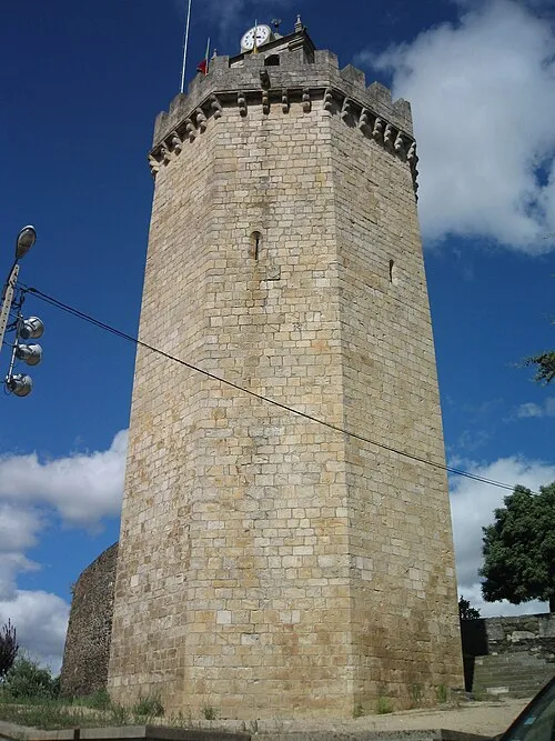 Castelo de Freixo de Espada à Cinta Historic site, União das freguesias de Freixo de Espada à Cinta e Mazouco8.5 km NE
-
Arroyo de la Nava River, Vilvestre12 km NE
-
Lamelas Frias Mountain, União das freguesias de Freixo de Espada à Cinta e Mazouco17 km N
Sources & licences
Data last updated: