- Population
- 1,011
- 1K
- Elevation
- 5 m
- above sea level
- Local time
- UTC+01:00
- Europe/Madrid · UTC+01:00
- Places inside
- 26
- listed under el Port de la Selva
- Airports
- PGF Perpignan-Rivesaltes (Llabanère) Airport53 km
- GRO Girona-Costa Brava Airport60 km
About el Port de la Selva
el Port de la Selva is a municipality. Location: Girona, Catalonia. Population: 1,011. Elevation: 5 m. The best months to visit are May–October. The nearest airport is Perpignan-Rivesaltes (Llabanère) Airport (53 km). Nearby sights include Badia del Port de la Selva and Puig del Vaquer.
Climate of el Port de la Selva
Best months for sightseeingBest months for sightseeing: May–October.
This month · November
Outside the best season
Day 16° · Night 9° · Rain 47 mm
- Hottest month
- July (day 29°)
- Coldest month
- January (night 5°)
- Wettest month
- October (77 mm)
- Driest month
- July (15 mm)
Bars: average monthly low and high temperature. Below: precipitation. Monthly averages for 1970–2000 at about 18 km resolution, adjusted for elevation. Highlighted months are mild and relatively dry. Source: WorldClim 2.1 (CC BY 4.0).
Show values as a table
| Month | Jan | Feb | Mar | Apr | May | Jun | Jul | Aug | Sep | Oct | Nov | Dec |
|---|---|---|---|---|---|---|---|---|---|---|---|---|
| Average high (°C) | 13° | 14° | 16° | 17° | 21° | 25° | 29° | 28° | 25° | 20° | 16° | 14° |
| Average low (°C) | 5° | 6° | 7° | 9° | 13° | 17° | 19° | 19° | 16° | 13° | 9° | 6° |
| Precipitation (mm) | 39 | 36 | 45 | 46 | 41 | 33 | 15 | 38 | 60 | 77 | 47 | 51 |
Other places to visit in this season: May June July August September October
How to get to el Port de la Selva
The nearest airport is Perpignan-Rivesaltes (Llabanère) Airport (PGF), 53 km to the northwest as the crow flies. For international flights: Girona-Costa Brava Airport (GRO) (60 km). The nearest large city is Perpignan, 48 km to the northwest.
Airports
- Perpignan-Rivesaltes (Llabanère) Airport (PGF) Perpignan/Rivesaltes 53 kmnorthwest
- Girona-Costa Brava Airport (GRO) Girona 60 kmsouthwest
- Béziers Vias airport (BZR) Béziers 111 kmnorth
Nearby large cities
- Perpignan Population: 110.7K 48 kmnorthwest
- Girona Population: 100.3K 50 kmsouthwest
- Mataró Population: 127K 108 kmsouthwest
- Sabadell Population: 211.7K 126 kmsouthwest
- Badalona Population: 217.7K 126 kmsouthwest
Straight-line distances; road distances are longer. Airport data: OurAirports.
Day trips from el Port de la Selva
Within 100 km: 249 historic and cultural sites, 965 natural sites, 271 lakes, rivers and coasts.
0–25 km252 places
- Platja de Perafita Beach 14 kmN
- Puig Joan Mountain 14 kmN
- Platja de Port-alguer Beach 8 kmSE
- Platja del Rec del Molí Beach 24 kmS
25–60 km418 places
- Platja de Port Pelegrí Beach 50 kmS
- Platgeta d'en Cosme Beach 50 kmS
- Platja d'en Calau Beach 50 kmS
- Platja d'Aiguablava Beach 45 kmS
60–100 km815 places
- Platja de Lloret Beach 77 kmSW
- Platja de Canyelles Beach 75 kmS
- Cala del Vigatà Beach 64 kmS
- Cala de Salionç Beach 68 kmS
Straight-line distances.
Places in el Port de la Selva
26 placesBar: population relative to the most populous place in this list.
Cities & villages6
- Barlovent · Neighbourhood
- Cap de Bol · Village
- la Vall de Santa Creu · Village
- Perabeua · Neighbourhood
- Santa Isabel · Village
- sa Perafita · Village
Mountains & nature13
- Cap Gros · Natural site
- Cap Ravener · Natural site
- la Roca · Mountain
- Puig Alt Gran · Mountain
- Puig de Cala Sardina · Mountain
- Puig de l'Infern · Mountain
- Puig dels Bufadors · Mountain
- Puig de Moro · Mountain
- Puig Gros · Mountain
- Punta Blanca · Natural site
- Punta dels Tres Frares · Natural site
- Sant Salvador Saverdera · Mountain
- Turó d'en Llaures · Mountain
Lakes, rivers & coasts4
- Cala Tamariua · Beach
- Cala Tavellera · Beach
- Platja de la Rivera · Beach
- Platja de la Vall · Beach
Heritage & sights2
- Castell de Verdera · Historic site
- Sant Pere de Rodes · Attraction
Nearby attractions & nature
Everything nearby-
Badia del Port de la Selva Natural site, Catalonia1.4 km NW
-
Puig del Vaquer Mountain, Llançà3.1 km W
-
Punta dels Farallons Natural site, Girona4.9 km E
-
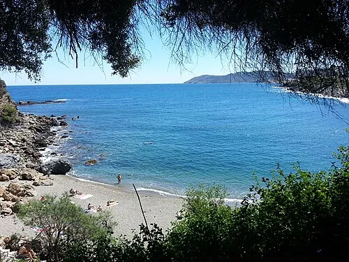 Platja del Cau del Llop Beach, Llançà4.3 km NW
-
Puig de Queralbs Mountain, la Selva de Mar3.8 km SW
-
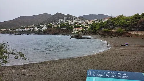 Platja de la Farella Beach, Llançà4.6 km NW
-
el Golfet Natural site, Catalonia4 km E
-
Platja de les Tonyines Beach, Llançà4.6 km NW
Sources & licences
Data last updated: