Valencia do Sil
Located in Vilamartín de Valdeorras, Ourense Coordinates: 42°24′08″ N 7°04′33″ W
- Elevation
- 305 m
- above sea level
- Local time
- UTC+01:00
- Europe/Madrid · UTC+01:00
- Airports
- BGC Bragança Airport68 km
- LEN León Airport119 km
About Valencia do Sil
Valencia do Sil is a village. Location: Vilamartín de Valdeorras, Ourense. Elevation: 305 m. The best months to visit are May–September. The nearest airport is Bragança Airport (68 km). Nearby sights include Río Leira and Regato da Fervenza.
Climate of Valencia do Sil
Best months for sightseeingBest months for sightseeing: May–September.
This month · November
A wet month
Day 15° · Night 7° · Rain 165 mm
- Hottest month
- July (day 29°)
- Coldest month
- January (night 4°)
- Wettest month
- December (181 mm)
- Driest month
- July (34 mm)
Bars: average monthly low and high temperature. Below: precipitation. Monthly averages for 1970–2000 at about 18 km resolution, adjusted for elevation. Highlighted months are mild and relatively dry. Source: WorldClim 2.1 (CC BY 4.0).
Show values as a table
| Month | Jan | Feb | Mar | Apr | May | Jun | Jul | Aug | Sep | Oct | Nov | Dec |
|---|---|---|---|---|---|---|---|---|---|---|---|---|
| Average high (°C) | 11° | 13° | 16° | 17° | 21° | 25° | 29° | 29° | 26° | 20° | 15° | 12° |
| Average low (°C) | 4° | 5° | 6° | 8° | 10° | 14° | 16° | 16° | 14° | 11° | 7° | 5° |
| Precipitation (mm) | 169 | 137 | 107 | 108 | 104 | 58 | 34 | 36 | 81 | 155 | 165 | 181 |
Other places to visit in this season: May June July August September
How to get to Valencia do Sil
The nearest airport is Bragança Airport (BGC), 68 km to the southeast as the crow flies. For international flights: Santiago-Rosalía de Castro Airport (SCQ) (123 km). The nearest large city is Ourense, 65 km to the west.
Airports
- Bragança Airport (BGC) Bragança 68 kmsoutheast
- León Airport (LEN) La Virgen del Camino 119 kmeast
- Santiago-Rosalía de Castro Airport (SCQ) Santiago de Compostela 123 kmnorthwest
Nearby large cities
- Ourense Population: 105.2K 65 kmwest
- León Population: 124.8K 126 kmeast
- Vigo Population: 293.6K 137 kmwest
- Braga Population: 193.3K 146 kmsouthwest
- Oviedo Population: 220K 146 kmnortheast
Straight-line distances; road distances are longer. Airport data: OurAirports.
Day trips from Valencia do Sil
Within 100 km: 78 historic and cultural sites, 157 natural sites, 270 lakes, rivers and coasts.
0–25 km34 places
- Pía Paxaro Mountain 21 kmN
- Cabeza de Manzaneda Mountain 24 kmSW
- Paxaro Mountain 20 kmN
- Campín de Murelos Mountain 21 kmN
25–60 km179 places
- Lago de Sanabria Lake 43 kmSE
- Sierra de la Gamoneda Mountain 49 kmSE
- Serra do Invernadoiro Mountain 35 kmSW
- Alto da Viuveza Mountain 52 kmW
60–100 km292 places
- Pantano de Villameca Lake 87 kmE
- Embalse de Belesar Lake 61 kmNW
- Sierra de Casica Mountain 96 kmSE
- Sierra de Larouca Mountain 73 kmSW
Straight-line distances.
Nearby attractions & nature
Everything nearby-
Río Leira River, Vilamartín de Valdeorras1.9 km NE
-
Regato da Fervenza River, Barco de Valdeorras, O4.9 km E
-
Arroyo de Pincheira River, Quiroga5.3 km W
-
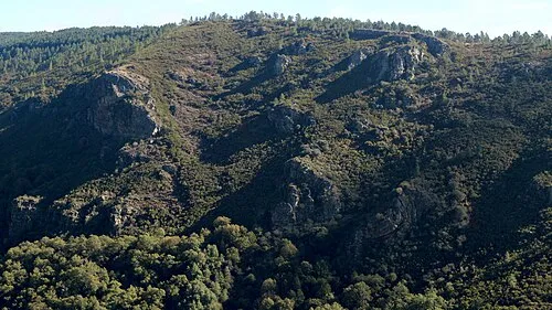 Serra do Courel Mountain, Folgoso do Courel21 km N
-
Arroyo Balado River, Barco de Valdeorras, O7.9 km E
-
Fonte Forraxes Natural site, A Veiga15 km SE
Sources & licences
Data last updated: