Thal
Located in Electoral district of Rorschach, Canton of St. Gallen Coordinates: 47°28′42″ N 9°33′24″ E

- Population
- 6,565
- 6.6K
- Elevation
- 397 m
- above sea level
- Local time
- UTC+01:00
- Europe/Zurich · UTC+01:00
- Places inside
- 5
- listed under Thal
- Airports
- ACH Sankt Gallen Altenrhein Airport1 km
- FDH Bodensee Airport Friedrichshafen22 km
About Thal
Thal is a municipality. Location: Electoral district of Rorschach, Canton of St. Gallen. Population: 6,565. Elevation: 397 m.
Thal (German pronunciation: [ˈtaːl]) is a village and municipality in the Wahlkreis (constituency) of Rorschach in the canton of St. Gallen in Switzerland. Besides the village of Thal itself, the municipality also includes the villages of Altenrhein, Buechen, Buriet and Staad.
Source: Wikipedia · CC BY-SA 4.0
Photos of Thal
-

Kecko · CC BY 2.0 -

Kecko · CC BY 2.0 -

Andreas Praefcke · CC BY 4.0 -

Thomas Woodtli from Zürich, Switzerland · CC BY-SA 2.0 -

Kecko from Switzerland · CC BY 2.0


Population of Thal over time
| 2017 | 6,480 | |
|---|---|---|
| 2018 | 6,570 | |
| 2025 | 7,217 |
Censuses and official estimates; source: Wikidata.
Climate of Thal
Best months for sightseeingBest months for sightseeing: May–September.
This month · November
A wet month
Day 8° · Night 2° · Rain 102 mm
- Hottest month
- July (day 24°)
- Coldest month
- January (night -2°)
- Wettest month
- July (166 mm)
- Driest month
- January (69 mm)
Bars: average monthly low and high temperature. Below: precipitation. Monthly averages for 1970–2000 at about 18 km resolution, adjusted for elevation. Highlighted months are mild and relatively dry. Source: WorldClim 2.1 (CC BY 4.0).
Show values as a table
| Month | Jan | Feb | Mar | Apr | May | Jun | Jul | Aug | Sep | Oct | Nov | Dec |
|---|---|---|---|---|---|---|---|---|---|---|---|---|
| Average high (°C) | 4° | 5° | 10° | 14° | 19° | 22° | 24° | 23° | 20° | 14° | 8° | 5° |
| Average low (°C) | -2° | -1° | 2° | 4° | 9° | 12° | 14° | 14° | 11° | 7° | 2° | -1° |
| Precipitation (mm) | 69 | 73 | 79 | 103 | 123 | 159 | 166 | 154 | 118 | 90 | 102 | 83 |
Other places to visit in this season: May June July August September
How to get to Thal
The nearest airport is Sankt Gallen Altenrhein Airport (ACH), 1 km to the north as the crow flies. For international flights: Bodensee Airport Friedrichshafen (FDH) (22 km). The nearest large city is Winterthur, 63 km to the west.
Airports
- Sankt Gallen Altenrhein Airport (ACH) St. Gallen 1 kmnorth
- Bodensee Airport Friedrichshafen (FDH) Friedrichshafen 22 kmnorth
- Zürich Airport (ZRH) Zurich 76 kmwest
Nearby large cities
- Winterthur Population: 111.8K 63 kmwest
- Zurich Population: 415.4K 77 kmwest
- Ulm Population: 120.5K 107 kmnorth
- Reutlingen Population: 112.6K 116 kmnorth
- Freiburg im Breisgau Population: 237.5K 140 kmnorthwest
Straight-line distances; road distances are longer. Airport data: OurAirports.
Day trips from Thal
Within 100 km: 493 historic and cultural sites, 5,235 natural sites, 1,165 lakes, rivers and coasts.
0–25 km249 places
- Weiher Diepoldsau Lake 14 kmSE
- Uttwiler Weiher Lake 19 kmNW
- Alter Rhein Lake 14 kmSE
- Hauptswiler Weiher Lake 23 kmW
25–60 km2,067 places
- Mainau Island 37 kmNW
- Dominikanerinsel Konstanz Island 35 kmNW
- Strandbad Steckborn Beach 48 kmNW
- Insel Werd Island 56 kmW
60–100 km4,577 places
- Fahr Abbey Attraction 85 kmW
- Ufenau Island 66 kmSW
- Insel Lützelau Island 64 kmSW
- Schönenwerd Island 70 kmSW
Straight-line distances.
Places in Thal
5 placesBar: population relative to the most populous place in this list.
Cities & villages4
- Altenrhein · Village
- Am Rhein · Village
- Buechstiggass · Village
- Staad · Village
Nearby attractions & nature
Everything nearby-
Rheinholz Gaißau Natural site, Vorarlberg2 km NE
-
Alter Rheinlauf River, Switzerland2.4 km N
-
Eselschwanzweiher Lake, St. Margrethen4.1 km E
-
Goldbach River, Switzerland6.2 km W
-
Fußacher Bucht Bodensee Lake, Vorarlberg7 km E
-
Schlossweiher Lake, Untereggen7.3 km W
-
Burgruine Hoch Altstätten Historic site, Oberegg8.7 km S
-
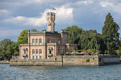 Schloß Montfort Historic site, Langenargen13 km N
Sources & licences
Data last updated: · 2 independent sources