Arrondissement of Ambert
Located in Puy-de-Dôme, Auvergne-Rhône-Alpes Coordinates: 45°32′43″ N 3°42′01″ E
- Population
- 27,596
- 27.6K
- Elevation
- 742 m
- above sea level
- Local time
- UTC+01:00
- Europe/Paris · UTC+01:00
- Places inside
- 58
- listed under Arrondissement of Ambert
- Airports
- CFE Clermont-Ferrand Auvergne airport49 km
- LYS Lyon Saint-Exupéry Airport110 km
About Arrondissement of Ambert
Arrondissement of Ambert is a municipality. Location: Puy-de-Dôme, Auvergne-Rhône-Alpes. Population: 27,596. Elevation: 742 m. The best months to visit are July–August. The nearest airport is Clermont-Ferrand Auvergne airport (49 km). Nearby sights include Bois de Coisse and Monts du Forez.
Photos of Arrondissement of Ambert
-
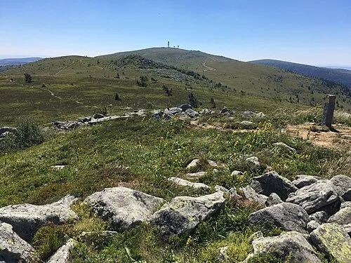
Pierre-sur-Haute Nezdek · CC BY-SA 4.0

Climate of Arrondissement of Ambert
Best months for sightseeingBest months for sightseeing: July–August.
This month · November
A cold month
Day 8° · Night 1° · Rain 63 mm
- Hottest month
- July (day 23°)
- Coldest month
- January (night -2°)
- Wettest month
- May (92 mm)
- Driest month
- February (45 mm)
Bars: average monthly low and high temperature. Below: precipitation. Monthly averages for 1970–2000 at about 18 km resolution, adjusted for elevation. Highlighted months are mild and relatively dry. Source: WorldClim 2.1 (CC BY 4.0).
Show values as a table
| Month | Jan | Feb | Mar | Apr | May | Jun | Jul | Aug | Sep | Oct | Nov | Dec |
|---|---|---|---|---|---|---|---|---|---|---|---|---|
| Average high (°C) | 5° | 6° | 9° | 11° | 16° | 19° | 23° | 23° | 19° | 14° | 8° | 6° |
| Average low (°C) | -2° | -1° | 1° | 3° | 7° | 10° | 12° | 12° | 9° | 6° | 1° | -1° |
| Precipitation (mm) | 53 | 45 | 49 | 65 | 92 | 82 | 66 | 81 | 81 | 75 | 63 | 56 |
How to get to Arrondissement of Ambert
The nearest airport is Clermont-Ferrand Auvergne airport (CFE), 49 km to the northwest as the crow flies. The nearest large city is Clermont-Ferrand, 54 km to the northwest.
Airports
- Clermont-Ferrand Auvergne airport (CFE) Clermont-Ferrand 49 kmnorthwest
- Lyon Saint-Exupéry Airport (LYS) Colombier-Saugnieu, Rhône 110 kmeast
- Aurillac airport (AUR) Aurillac 124 kmsouthwest
Nearby large cities
- Clermont-Ferrand Population: 147.9K 54 kmnorthwest
- Saint-Etienne Population: 176.3K 55 kmeast
- Lyon Population: 520.8K 92 kmeast
- Villeurbanne Population: 131.4K 95 kmeast
- Grenoble Population: 158.6K 163 kmeast
Straight-line distances; road distances are longer. Airport data: OurAirports.
Day trips from Arrondissement of Ambert
Within 100 km: 167 historic and cultural sites, 763 natural sites, 268 lakes, rivers and coasts.
0–25 km42 places
- Puy Bien Mountain 22 kmN
- Rocher de Pierre Dure Mountain 13 kmE
- Puy Gros Mountain 18 kmN
- Montagne de Monthiallier Mountain 12 kmNE
25–60 km288 places
- Lac d'Aydat Lake 57 kmW
- Lac de la Cassière Lake 57 kmW
- Petit Lac Mountain 49 kmSE
- Puy d'Oscot Mountain 32 kmN
60–100 km868 places
- Parc de la Tête d'Or Natural site 94 kmE
- Étang de Tix Lake 98 kmW
- Lac de Tazenat Lake 73 kmNW
- Lac de Servière Lake 67 kmW
Straight-line distances.
Places in Arrondissement of Ambert
58 places- 1 Ambert 6.7K
- 2 Arlanc 1.9K
- 3 Marsac-en-Livradois 1.5K
- 4 Cunlhat 1.3K
- 5 Job 1K
- 6 Marat 823
- 7 Olliergues 751
- 8 Saint-Anthème 697
- 9 Dore-l'Église 621
- 10 Saint-Ferréol-des-Côtes 543
- 11 Vertolaye 537
- 12 Sauvessanges 517
- 13 Tours-sur-Meymont 516
- 14 Saint-Amant-Roche-Savine 495
- 15 Saint-Germain-l'Herm 492
- 16 Bertignat 455
- 17 Viverols 410
- 18 Domaize 389
- 19 La Chapelle-Agnon 357
- 20 Auzelles 354
- 21 Brousse 342
- 22 La Forie 322
- 23 Fournols 320
- 24 Beurières 301
- 25 Saint-Martin-des-Olmes 290
- 26 Saillant 278
- 27 Champétières 270
- 28 Églisolles 261
- 29 Échandelys 260
- 30 Le Brugeron 247
- 31 Saint-Gervais-sous-Meymont 239
- 32 Chaumont-le-Bourg 232
- 33 Saint-Clément-de-Valorgue 230
- 34 Condat-lès-Montboissier 225
- 35 Saint-Romain 214
- 36 Valcivières 209
- 37 Saint-Bonnet-le-Chastel 208
- 38 Le Monestier 207
- 39 Mayres 195
- 40 Grandrif 179
- 41 Ceilloux 178
- 42 Saint-Alyre-d'Arlanc 171
- 43 Chambon-sur-Dolore 163
- 44 Thiolières 163
- 45 Saint-Just 158
- 46 Saint-Bonnet-le-Bourg 154
- 47 Doranges 150
- 48 Novacelles 141
- 49 Saint-Pierre-la-Bourlhonne 128
- 50 La Chaulme 117
- 51 Medeyrolles 116
- 52 Grandval 114
- 53 Baffie 113
- 54 Fayet-Ronaye 106
- 55 Saint-Sauveur-la-Sagne 96
- 56 Aix-la-Fayette 91
- 57 Saint-Éloy-la-Glacière 56
- 58 Sainte-Catherine 53
Bar: population relative to the most populous place in this list.
Nearby attractions & nature
Everything nearby-
Bois de Coisse Natural site, Puy-de-Dôme8.3 km SW
-
Monts du Forez Mountain, Puy-de-Dôme15 km NE
-
Monts du Livradois Mountain, Puy-de-Dôme13 km SW
-
Dolore River, Puy-de-Dôme11 km S
-
Bois de la Grange Natural site, Puy-de-Dôme13 km NE
-
Bois de Naufrange Natural site, Puy-de-Dôme13 km E
-
Vertolaye River, Puy-de-Dôme12 km N
-
Bois de Mauchet Natural site, Puy-de-Dôme12 km W
Sources & licences
Data last updated: