Leutesdorf
Located in Landkreis Neuwied, Rhineland-Palatinate Coordinates: 50°27′00″ N 7°23′00″ E
- Population
- 1,882
- 1.9K
- Elevation
- 58 m
- above sea level
- Local time
- UTC+01:00
- Europe/Berlin · UTC+01:00
- Places inside
- 3
- listed under Leutesdorf
- Airports
- CGN Cologne Bonn Airport49 km
- HHN Frankfurt-Hahn Airport57 km
About Leutesdorf
Leutesdorf is a village. Location: Landkreis Neuwied, Rhineland-Palatinate. Population: 1,882. Elevation: 58 m. The best months to visit are May–September. The nearest airport is Cologne Bonn Airport (49 km). Nearby sights include Krahnenberg and Round Tower.
Photos of Leutesdorf
-
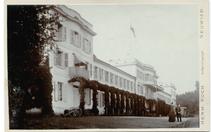
Schloß Monrepos Herman Koch · Public domain

Climate of Leutesdorf
Best months for sightseeingBest months for sightseeing: May–September.
This month · November
A cold month
Day 9° · Night 3° · Rain 59 mm
- Hottest month
- July (day 24°)
- Coldest month
- February (night -1°)
- Wettest month
- July (73 mm)
- Driest month
- February (44 mm)
Bars: average monthly low and high temperature. Below: precipitation. Monthly averages for 1970–2000 at about 18 km resolution, adjusted for elevation. Highlighted months are mild and relatively dry. Source: WorldClim 2.1 (CC BY 4.0).
Show values as a table
| Month | Jan | Feb | Mar | Apr | May | Jun | Jul | Aug | Sep | Oct | Nov | Dec |
|---|---|---|---|---|---|---|---|---|---|---|---|---|
| Average high (°C) | 5° | 6° | 10° | 14° | 20° | 22° | 24° | 24° | 20° | 14° | 9° | 6° |
| Average low (°C) | 0° | -1° | 2° | 4° | 9° | 12° | 14° | 13° | 10° | 6° | 3° | 1° |
| Precipitation (mm) | 54 | 44 | 55 | 50 | 62 | 68 | 73 | 58 | 58 | 58 | 59 | 62 |
Other places to visit in this season: May June July August September
How to get to Leutesdorf
The nearest airport is Cologne Bonn Airport (CGN), 49 km to the north as the crow flies. The nearest large city is Koblenz, 18 km to the southeast.
Airports
- Cologne Bonn Airport (CGN) Köln (Cologne) 49 kmnorth
- Frankfurt-Hahn Airport (HHN) Frankfurt am Main (Lautzenhausen) 57 kmsouth
- Frankfurt Main Airport (FRA) Frankfurt am Main 96 kmsoutheast
Nearby large cities
- Koblenz Population: 107.3K 18 kmsoutheast
- Bonn Population: 330.6K 38 kmnorthwest
- Cologne Population: 1M 62 kmnorthwest
- Bergisch Gladbach Population: 106.2K 62 kmnorth
- Siegen Population: 107.2K 65 kmnortheast
Straight-line distances; road distances are longer. Airport data: OurAirports.
Day trips from Leutesdorf
Within 100 km: 727 historic and cultural sites, 3,872 natural sites, 925 lakes, rivers and coasts.
0–25 km488 places
- Urbach River 14 kmNE
- Laacher See Lake 9 kmSW
- Wald-See Lake 8 kmSW
- Rodder Maar Lake 14 kmW
25–60 km1,619 places
- Weibe River 59 kmNE
- Aar River 45 kmE
- Kemper Werth Island 41 kmNW
- Hatzenporter Werth Island 25 kmS
60–100 km3,417 places
- Lac d'Eupen Lake 93 kmW
- Lac de Robertville Lake 90 kmW
- Steinkopf Mountain 91 kmW
- Steiner Berg Mountain 94 kmW
Straight-line distances.
Places in Leutesdorf
3 placesBar: population relative to the most populous place in this list.
Mountains & nature2
- Auf der Heide · Mountain
- Lücken-Berg · Mountain
Nearby attractions & nature
Everything nearby-
Krahnenberg Mountain, Andernach0.8 km S
-
Round Tower Historic site, Andernach1.4 km SE
-
Agrippastrasse Tower Landmark, Andernach1.5 km SE
-
Rhine Gate Historic site, Andernach1.6 km SE
-
Andernacher Stadtwald Natural site, Rhineland-Palatinate1.7 km W
-
Dadenberg Tower Historic site, Andernach1.8 km SE
Other cities and towns in Landkreis Neuwied
-
 Melsbach Village, Landkreis Neuwied8 km NE
-
 Datzeroth Village, Landkreis Neuwied6.6 km NE
-
 Ehlscheid Village, Landkreis Neuwied8.8 km NE
-
Rheinbrohl Village, Landkreis Neuwied6.5 km NW
-
Bad Hönningen Village, Landkreis Neuwied8.8 km NW
-
Gönnersdorf Village, Neuwied2.3 km E
Sources & licences
Data last updated: