
- Population
- 2,361
- 2.4K
- Elevation
- 396 m
- above sea level
- Local time
- UTC+09:00
- Asia/Tokyo · UTC+09:00
- Places inside
- 1
- listed under Sai Mura
- Airports
- HKD Hakodate Airport46 km
- AOJ Aomori Airport70 km
About Sai Mura
Sai Mura is a municipality. Location: Shimokita-gun, Aomori. Population: 2,361. Elevation: 396 m.
Sai (佐井村, Sai-mura) is a village located in Aomori, Japan. As of 30 November 2025, the village had an estimated population of 1,572 in 842 households, and a population density of 12 persons per square kilometre. Its total area is 135.05 square kilometres (52.14 sq mi). In 2016, Sai was selected as one of The Most Beautiful Villages in Japan.
Source: Wikipedia · CC BY-SA 4.0
Travel notes for Sai Mura
From Wikivoyage
Sai Village (佐井村) is in Shimokita, Aomori, Japan.
Understand+
Sai Village is on the northwest coast of Shimokita Peninsula in Aomori Prefecture. It borders the Tsugaru Strait, and is mostly a mountainous region. The areas within Sai include Ushitaki, Fukuura, Chogo and Isoya. It is a quaint, quiet village with breathtaking scenery of both mountains and sea.
Tourist information site:
The local tourist association has a Japanese-only guide site.
Get in+
Sai is accessible by car, bus, or ferry.
From Mutsu:
From the Shimokita JR station in Mutsu, take the Shimokita bus heading to Sai. The bus ride takes about 2 hours and costs about ¥3,000.
Alternatively, you can rent a car. If you plan on exploring the gorgeous scenery, rent a car. Shimokita is not well connected by public transportation and the distances between towns are far. To get to Sai by car, follow the 279 north all the way to Oma where it intersects with the 338. Turn left (south) and follow the 338 into and through Sai. The drive is about an hour and 15 minutes.
From Hakodate:
Take the Tsugaru Kaikyo Ferry. The ferry makes two runs a day between Hakodate and Ōma. The ride is about 1 hour and 45 minutes. A return trip ticket costs about ¥4000. From Oma to Sai is a ¥2000 to ¥3000 cab ride or about a ¥500 bus ride.
From Tsugaru:
Take the Mutsuwan Ferry. It makes three runs between Kanita and Wakinosawa a day except for winter: late November to mid April. From Wakinosawa, you can catch the Shimokita bus directly to Sai.
Source: Wikivoyage · CC BY-SA 4.0 · abridged
Places bordering Sai Mura
- Mutsu
- Ōma Machi
Population of Sai Mura over time
| 2010 | 2,422 | |
|---|---|---|
| 2015 | 2,148 | |
| 2021 | 1,804 |
Censuses and official estimates; source: Wikidata.
Climate of Sai Mura
Best months for sightseeingBest months for sightseeing: July–September.
This month · November
A wet month
Day 8° · Night 1° · Rain 116 mm
- Hottest month
- August (day 23°)
- Coldest month
- January (night -7°)
- Wettest month
- September (171 mm)
- Driest month
- March (77 mm)
Bars: average monthly low and high temperature. Below: precipitation. Monthly averages for 1970–2000 at about 18 km resolution, adjusted for elevation. Highlighted months are mild and relatively dry. Source: WorldClim 2.1 (CC BY 4.0).
Show values as a table
| Month | Jan | Feb | Mar | Apr | May | Jun | Jul | Aug | Sep | Oct | Nov | Dec |
|---|---|---|---|---|---|---|---|---|---|---|---|---|
| Average high (°C) | -1° | -1° | 2° | 9° | 14° | 17° | 21° | 23° | 20° | 14° | 8° | 2° |
| Average low (°C) | -7° | -7° | -4° | 1° | 6° | 11° | 15° | 17° | 13° | 7° | 1° | -4° |
| Precipitation (mm) | 94 | 78 | 77 | 85 | 89 | 100 | 135 | 158 | 171 | 114 | 116 | 97 |
How to get to Sai Mura
The nearest airport is Hakodate Airport (HKD), 46 km to the north as the crow flies. The nearest large city is Hakodate, 48 km to the north.
Airports
- Hakodate Airport (HKD) Hakodate 46 kmnorth
- Aomori Airport (AOJ) Aomori 70 kmsouth
- Misawa Airport / Misawa Air Base (MSJ) Misawa 84 kmsoutheast
Nearby large cities
- Hakodate Population: 275.7K 48 kmnorth
- Aomori Population: 298.4K 60 kmsouth
- Hirosaki Population: 168.7K 90 kmsouth
- Hachinohe Population: 239K 109 kmsoutheast
- Tomakomai Population: 174.8K 156 kmnortheast
Straight-line distances; road distances are longer. Airport data: OurAirports.
Day trips from Sai Mura
Within 100 km: 6 historic and cultural sites, 19 natural sites, 13 lakes, rivers and coasts.
0–25 km3 places
- Usoriyama-ko Lake 21 kmE
- Osore-zan Mountain 19 kmE
- Shimokita Hantō Natural site 12 kmE
25–60 km18 places
- Lake Jūsan Lake 56 kmSW
- Mount Nagayama Mountain 58 kmNW
- Shiryōkaku Historic site 53 kmN
- Hakodate Arena Landmark 48 kmN
60–100 km17 places
- Lake Ogarawa Lake 75 kmSE
- Oirase River River 98 kmSE
- Seibi En Attraction 85 kmS
- Mount Iwaki Mountain 90 kmSW
Straight-line distances.
Places in Sai Mura
1 placeBar: population relative to the most populous place in this list.
Nearby attractions & nature
Everything nearby-
 Shimokita Hantō Natural site, Aomori12 km E
-
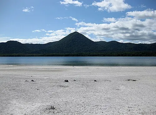 Osore-zan Mountain, Mutsu Shi19 km E
-
Usoriyama-ko Lake, Japan21 km E
Sources & licences
Data last updated: · 2 independent sources