Yahata-higashi Ku
Located in Kitakyushu City, Fukuoka Coordinates: 33°50′59″ N 130°48′32″ E
- Population
- 71,801
- 71.8K
- Elevation
- 264 m
- above sea level
- Local time
- UTC+09:00
- Asia/Tokyo · UTC+09:00
- Places inside
- 2
- listed under Yahata-higashi Ku
- Airports
- KKJ Kitakyushu Airport21 km
- FUK Fukuoka Airport44 km
About Yahata-higashi Ku
Yahata-higashi Ku is a municipality. Location: Kitakyushu City, Fukuoka. Population: 71,801. Elevation: 264 m.
Yahatahigashi-ku (八幡東区) is a ward of Kitakyūshū, Fukuoka, Japan. It is the second smallest ward in Kitakyūshū after Tobata ward at only 36.36 square kilometres. Residents have a very high average age, one of the highest in Japan. The population was 77,077 at the end of September 2003.
Source: Wikipedia · CC BY-SA 4.0
Photos of Yahata-higashi Ku
-
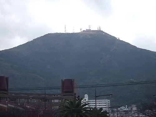
Mount Sarakura 投稿者 · CC BY-SA 3.0 -
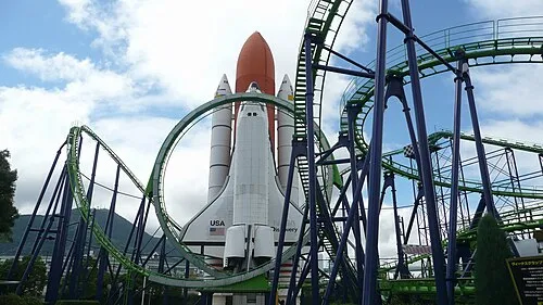
Space World ja:User:Sanjo · CC BY-SA 3.0


Population of Yahata-higashi Ku over time
| 2010 | 71,801 | |
|---|---|---|
| 2015 | 68,844 | |
| 2020 | 64,613 |
Censuses and official estimates; source: Wikidata.
Climate of Yahata-higashi Ku
Best months for sightseeingBest months for sightseeing: May–June, September–October.
This month · November
Outside the best season
Day 15° · Night 7° · Rain 80 mm
Better nearby cities in November
- Beppu · 90 km southeast17°
- Ōita · 100 km southeast18°
- Nobeoka · 162 km southeast18°
- Hottest month
- August (day 29°)
- Coldest month
- January (night 1°)
- Wettest month
- July (305 mm)
- Driest month
- December (67 mm)
Bars: average monthly low and high temperature. Below: precipitation. Monthly averages for 1970–2000 at about 18 km resolution, adjusted for elevation. Highlighted months are mild and relatively dry. Source: WorldClim 2.1 (CC BY 4.0).
Show values as a table
| Month | Jan | Feb | Mar | Apr | May | Jun | Jul | Aug | Sep | Oct | Nov | Dec |
|---|---|---|---|---|---|---|---|---|---|---|---|---|
| Average high (°C) | 8° | 8° | 11° | 17° | 21° | 24° | 28° | 29° | 25° | 21° | 15° | 10° |
| Average low (°C) | 1° | 1° | 4° | 9° | 13° | 17° | 22° | 22° | 19° | 13° | 7° | 3° |
| Precipitation (mm) | 80 | 88 | 108 | 155 | 153 | 263 | 305 | 140 | 205 | 97 | 80 | 67 |
Other places to visit in this season: May June September October
How to get to Yahata-higashi Ku
The nearest airport is Kitakyushu Airport (KKJ), 21 km to the east as the crow flies. The nearest large city is Shimonoseki, 17 km to the northeast.
Airports
- Kitakyushu Airport (KKJ) Kitakyushu 21 kmeast
- Fukuoka Airport (FUK) Fukuoka 44 kmsouthwest
- Yamaguchi Ube Airport (UBJ) Ube 44 kmeast
Nearby large cities
- Shimonoseki Population: 265.7K 17 kmnortheast
- Iizuka Population: 126.4K 26 kmsouthwest
- Ube Population: 173.7K 42 kmeast
- Ōnojō Population: 102.1K 46 kmsouthwest
- Chikushino-shi Population: 103.3K 48 kmsouthwest
Straight-line distances; road distances are longer. Airport data: OurAirports.
Day trips from Yahata-higashi Ku
Within 100 km: 16 historic and cultural sites, 15 natural sites, 12 lakes, rivers and coasts.
0–25 km7 places
- Hiko Shima Island 13 kmNE
- Kōzan Ji Attraction 23 kmNE
- Kanmon Kyō Landmark 19 kmNE
- Wakato Ōhashi Landmark 6 kmN
25–60 km21 places
- Tsuno Shima Island 56 kmN
- Kyūshū Kokuritsu Hakubutsukan Museum 45 kmSW
- Shika Island Island 51 kmW
- Mt. Abura Mountain 56 kmSW
60–100 km15 places
- Okino-shima Island 78 kmNW
- Mount Tsurumi Mountain 85 kmSE
- Kakara Shima Island 93 kmW
- Karatsu Castle Historic site 89 kmSW
Straight-line distances.
Yahata-higashi Ku and similar cities
Side by side with cities of similar size in the same country: population, elevation and climate.
| Measure | Yahata-higashi Ku | Yawata | Minami-Alps | Ōtawara |
|---|---|---|---|---|
| Population | 71.8K | 71.7K | 71.6K | 72.1K |
| Elevation | 264 m | 17 m | 298 m | 205 m |
| Summer day (hottest month) | 29° | 32° | 30° | 29° |
| Winter night (coldest month) | 1° | 1° | -2° | -3° |
| Annual rainfall | 1,741 mm | 1,533 mm | 1,465 mm | 1,293 mm |
| Best months | May–Jun, Sep–Oct | May, Oct | May–Jun, Oct | May–Jul, Sep–Oct |
| Distance | — | 464 km | 728 km | 902 km |
Climate values are 1970–2000 monthly averages; straight-line distance.
Places in Yahata-higashi Ku
2 placesNearby attractions & nature
Everything nearby-
Wakato Ōhashi Landmark, Fukuoka5.9 km N
-
 Hiko Shima Island, Shimonoseki Shi13 km NE
-
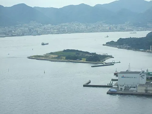 Ganryū-jima Island, Yamaguchi15 km NE
-
Kanmon Kyō Landmark, Japan19 km NE
-
Kōzan Ji Attraction, Shimonoseki Shi23 km NE
Sources & licences
Data last updated: · 2 independent sources