- Population
- 7,031
- 7K
- Elevation
- 851 m
- above sea level
- Local time
- UTC+09:00
- Asia/Tokyo · UTC+09:00
- Places inside
- 1
- listed under Takamori Machi
- Airports
- KMJ Kumamoto Airport33 km
- OIT Oita Airport87 km
About Takamori Machi
Takamori Machi is a municipality. Location: Aso-gun, Kumamoto. Population: 7,031. Elevation: 851 m.
Takamori (高森町, Takamori-machi) is a town located in Aso District, Kumamoto Prefecture, Japan. As of 1 August 2024, the town had an estimated population of 5889 in 2965 households, and a population density of 34 persons per km2. The total area of the town is 175.06 km2 (67.59 sq mi).
Source: Wikipedia · CC BY-SA 4.0
Travel notes for Takamori Machi
From Wikivoyage
Takamori (高森) is a town in the Kumamoto Prefecture on the Japanese island Kyushu. It is near the city of Kumamoto.
Understand+
Takamori sits at the easternmost point of Kumamoto Prefecture, within the caldera of Mount Aso.
Takamori has a humid subtropical climate with hot, humid summers and cool winters. There is significant precipitation throughout the year, especially during June and July.
The main industries of Takamori are agriculture, forestry, and tourism. Agriculture has developed through field crops, rice cultivation, flower and tobacco production, livestock farming, and forestry. Highland vegetables such as radishes and cabbages has been promoted, and watermelon and melon production have become popular.
Tourist information site:
The local Tourism Promotion Association has a multilingual guide site.
Get in+
By train:
Minamiaso Railway Company - Takamori Line
By car:
National Route 265
National Route 325
National Route 503
Source: Wikivoyage · CC BY-SA 4.0 · abridged
Places bordering Takamori Machi
- Aso
- Yamato Chō
- Minamiaso Mura
- Takedamachi
- Takachiho Chō
Population of Takamori Machi over time
| 2010 | 6,716 | |
|---|---|---|
| 2015 | 6,325 | |
| 2021 | 5,724 |
Censuses and official estimates; source: Wikidata.
Climate of Takamori Machi
Best months for sightseeingBest months for sightseeing: June–September.
This month · November
A cold month
Day 12° · Night 4° · Rain 85 mm
Better nearby cities in November
- Nobeoka · 52 km southeast18°
- Beppu · 56 km northeast17°
- Ōita · 57 km northeast18°
- Hottest month
- August (day 25°)
- Coldest month
- January (night -4°)
- Wettest month
- July (465 mm)
- Driest month
- December (62 mm)
Bars: average monthly low and high temperature. Below: precipitation. Monthly averages for 1970–2000 at about 18 km resolution, adjusted for elevation. Highlighted months are mild and relatively dry. Source: WorldClim 2.1 (CC BY 4.0).
Show values as a table
| Month | Jan | Feb | Mar | Apr | May | Jun | Jul | Aug | Sep | Oct | Nov | Dec |
|---|---|---|---|---|---|---|---|---|---|---|---|---|
| Average high (°C) | 3° | 5° | 8° | 14° | 18° | 21° | 24° | 25° | 22° | 17° | 12° | 6° |
| Average low (°C) | -4° | -3° | 0° | 5° | 10° | 14° | 18° | 19° | 15° | 9° | 4° | -2° |
| Precipitation (mm) | 69 | 105 | 151 | 203 | 240 | 426 | 465 | 300 | 243 | 135 | 85 | 62 |
Other places to visit in this season: June July August September
How to get to Takamori Machi
The nearest airport is Kumamoto Airport (KMJ), 33 km to the west as the crow flies. The nearest large city is Nobeoka, 52 km to the southeast.
Airports
- Kumamoto Airport (KMJ) Kumamoto 33 kmwest
- Oita Airport (OIT) Oita 87 kmnortheast
- Kyushu Saga International Airport (HSG) Saga 91 kmwest
Nearby large cities
- Nobeoka Population: 119.5K 52 kmsoutheast
- Beppu Population: 122.6K 56 kmnortheast
- Ōita Population: 477.7K 57 kmnortheast
- Honmachi Population: 123.1K 68 kmsouthwest
- Omuta Population: 132K 74 kmwest
Straight-line distances; road distances are longer. Airport data: OurAirports.
Day trips from Takamori Machi
Within 100 km: 7 historic and cultural sites, 15 natural sites, 9 lakes, rivers and coasts.
0–25 km2 places
- Mount Sobo Mountain 14 kmE
- Mount Aso Mountain 11 kmNW
25–60 km12 places
- Kyūshū Island 50 kmSW
- Mount Ōkueyama Mountain 31 kmE
- Hi Kawa River 60 kmSW
- Kumamoto castle Historic site 47 kmW
60–100 km17 places
- Mimigawa River River 68 kmSE
- Mount Osuzu Mountain 64 kmS
- Chikugo River River 86 kmNW
- Mount Unzen Mountain 87 kmW
Straight-line distances.
Places in Takamori Machi
1 placeBar: population relative to the most populous place in this list.
Nearby attractions & nature
Everything nearby-
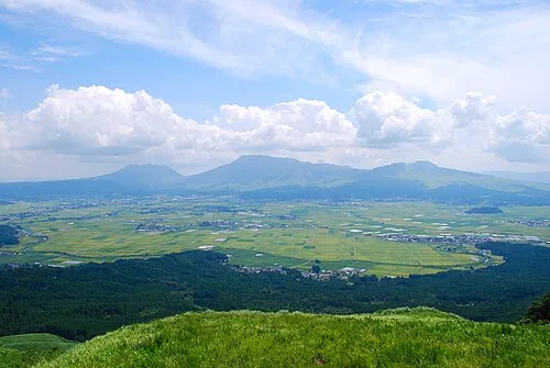 Mount Aso Mountain, Kumamoto11 km NW
-
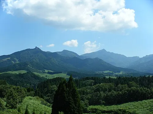 Mount Sobo Mountain, Bungo-ōno Shi14 km E
Sources & licences
Data last updated: · 2 independent sources